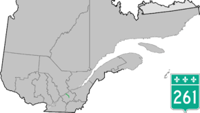
Quebec Route 261
Route 261 is a north/south highway on the south shore of the Saint Lawrence River in Quebec, Canada. Its northern terminus is in Bécancour (south of Trois-Rivières) at the junction of Route 132 and its southern terminus is in Saint-Valère at the junction of Route 161.
| ||||
|---|---|---|---|---|
 | ||||
| Route information | ||||
| Length | 37.0 km[1] (23.0 mi) | |||
| Major junctions | ||||
| South end | ||||
| North end | ||||
| Location | ||||
| Major cities | Becancour, Daveluyville | |||
| Highway system | ||||
| ||||

Towns along Route 261
- Becancour
- Saint-Sylvere
- Maddington
- Daveluyville
- Sainte-Anne-du-Sault
- Saint-Valere
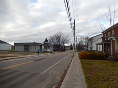 Route 261 in Daveluyville.
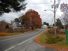 Route 261 in Maddington Falls.
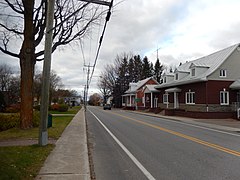 Intersection with Route 226 in Sainte-Gertrude.
gollark: Never!
gollark: ++list_deleted
gollark: It wprks now!
gollark: ++exec```pythondef f(x, y, z): if y == 0: if z == 0: return x return f(x, 0, z - 1) * f(x, 0, z - 1) return f(x, y - 1, z) * f(x, y - 1, z)print(f(10, 10, 10))```
gollark: ++exec```luafunction f(x, y, z)if y == 0 thenif z == 0 thenreturn xendreturn f(x, 0, z - 1) * f(x, 0, z - 1)endreturn f(x, y - 1, z) * f(x, y - 1, z)endprint(f(3, 3, 3))```
See also
References
- Ministère des transports, "Distances routières", page (?), Les Publications du Québec, 2005
External links
- Route 261 on Google Maps
- Provincial Route Map (Courtesy of the Quebec Ministry of Transportation) (in French)
This article is issued from Wikipedia. The text is licensed under Creative Commons - Attribution - Sharealike. Additional terms may apply for the media files.