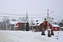
Sainte-Marthe, Quebec
Sainte-Marthe is a municipality located in the Vaudreuil-Soulanges Regional County Municipality of Quebec, Canada. The population as of the Canada 2011 Census was 1,075.
Sainte-Marthe | |
|---|---|
Municipality | |
 | |
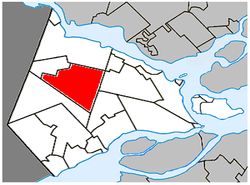 Location within Vaudreuil-Soulanges RCM | |
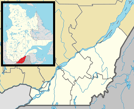 Ste-Marthe Location in southern Quebec | |
| Coordinates: 45°24′N 74°18′W[1] | |
| Country | |
| Province | |
| Region | Montérégie |
| RCM | Vaudreuil-Soulanges |
| Constituted | 27 December 1980 |
| Government | |
| • Mayor | François Pleau |
| • Federal riding | Salaberry—Suroît |
| • Prov. riding | Soulanges |
| Area | |
| • Total | 80.10 km2 (30.93 sq mi) |
| • Land | 79.80 km2 (30.81 sq mi) |
| Population (2011)[4] | |
| • Total | 1,075 |
| • Density | 13.5/km2 (35/sq mi) |
| • Pop 2006-2011 | |
| • Dwellings | 430 |
| Time zone | UTC−5 (EST) |
| • Summer (DST) | UTC−4 (EDT) |
| Postal code(s) | J0P 1W0 |
| Area code(s) | 450 and 579 |
| Highways | |
| Website | www |
Demographics
Population
| Canada census – Sainte-Marthe, Quebec community profile | |||
|---|---|---|---|
| 2011 | 2006 | ||
| Population: | 1,075 (-0.5% from 2006) | 1,080 (-1.3% from 2001) | |
| Land area: | 79.80 km2 (30.81 sq mi) | 79.69 km2 (30.77 sq mi) | |
| Population density: | 13.5/km2 (35/sq mi) | 13.6/km2 (35/sq mi) | |
| Median age: | 44.5 (M: 44.7, F: 44.3) | 43.0 (M: 43.0, F: 43.0) | |
| Total private dwellings: | 430 | 421 | |
| Median household income: | $56,221 | $47,512 | |
| References: 2011[4] 2006[5] earlier[6] | |||
| Year | Pop. | ±% |
|---|---|---|
| 1991 | 1,056 | — |
| 1996 | 1,090 | +3.2% |
| 2001 | 1,094 | +0.4% |
| 2006 | 1,080 | −1.3% |
| 2011 | 1,075 | −0.5% |
Language
| Canada Census Mother Tongue - Sainte-Marthe, Quebec[7] | ||||||||||||||||||
|---|---|---|---|---|---|---|---|---|---|---|---|---|---|---|---|---|---|---|
| Census | Total | French |
English |
French & English |
Other | |||||||||||||
| Year | Responses | Count | Trend | Pop % | Count | Trend | Pop % | Count | Trend | Pop % | Count | Trend | Pop % | |||||
2011 |
1,075 |
875 | 81.40% | 150 | 13.95% | 15 | 1.40% | 35 | 3.25% | |||||||||
2006 |
1,075 |
890 | 82.79% | 145 | 13.49% | 25 | 2.32% | 15 | 1.40% | |||||||||
2001 |
1,090 |
945 | 86.70% | 120 | 11.01% | 10 | 0.92% | 15 | 1.38% | |||||||||
1996 |
1,095 |
860 | n/a | 78.54% | 135 | n/a | 12.33% | 10 | n/a | 0.91% | 90 | n/a | 8.22% | |||||
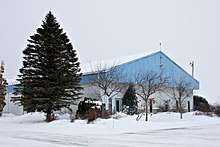
Municipal hall of Ste-Marthe
Education
Commission Scolaire des Trois-Lacs operates Francophone schools.[8]
- École Sainte-Marthe
Lester B. Pearson School Board operates Anglophone schools.[9]
- Soulanges Elementary School in Saint-Télesphore or Evergreen Elementary and Forest Hill Elementary (Junior Campus and Senior campus) in Saint-Lazare
gollark: What are the security issues, exactly?
gollark: Well, they're only accessible within potatOS.
gollark: ↑
gollark: Yes.
gollark: Superglobals can be accessed from any potatOS computer.
See also
References
- Reference number 98667 of the Commission de toponymie du Québec (in French)
- Ministère des Affaires municipales, des Régions et de l'Occupation du territoire: Sainte-Marthe
- Parliament of Canada Federal Riding History: VAUDREUIL--SOULANGES (Quebec)
- "2011 Community Profiles". 2011 Canadian Census. Statistics Canada. 5 July 2013. Retrieved 20 February 2014.
- "2006 Community Profiles". 2006 Canadian Census. Statistics Canada. 30 March 2011. Retrieved 20 February 2014.
- "2001 Community Profiles". 2001 Canadian Census. Statistics Canada. 17 February 2012.
- Statistics Canada: 1996, 2001, 2006, 2011 census
- "Les écoles et les centres". Commission Scolaire des Trois-Lacs. Retrieved 18 January 2013.
- "School Board Map." Lester B. Pearson School Board. Retrieved on 28 September 2017.
External links

Places adjacent to Sainte-Marthe, Quebec | ||||||||||
|---|---|---|---|---|---|---|---|---|---|---|
| ||||||||||
| Cities & towns | |
|---|---|
| Municipalities | |
| Villages | |
| |
This article is issued from Wikipedia. The text is licensed under Creative Commons - Attribution - Sharealike. Additional terms may apply for the media files.