Rigaud, Quebec
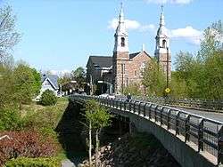
Rigaud (French pronunciation: [ʁigo]) is a city in southwestern Quebec, Canada in the county of Vaudreuil-Soulanges in Vallée-du-Haut-Saint-Laurent region. It is located at the junction of Ottawa River and Rigaud River. It is situated about 70 kilometres west of downtown Montreal and 130 kilometres east of Ottawa. The population as of the Canada 2011 Census was 7,346.
Rigaud | |
|---|---|
City | |
 | |
 Location within Vaudreuil-Soulanges RCM | |
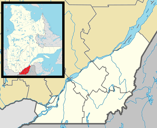 Rigaud Location in southern Quebec | |
| Coordinates: 45°29′N 74°18′W[1] | |
| Country | |
| Province | |
| Region | Montérégie |
| RCM | Vaudreuil-Soulanges |
| Constituted | 29 November 1995 |
| Government | |
| • Mayor | Hans Gruenwald Jr |
| • Federal riding | Vaudreuil-Soulanges |
| • Prov. riding | Soulanges |
| Area | |
| • Total | 114.00 km2 (44.02 sq mi) |
| • Land | 99.12 km2 (38.27 sq mi) |
| Population (2014)[4] | |
| • Total | 7,566 |
| • Density | 74.1/km2 (192/sq mi) |
| • Pop 2006–2011 | |
| • Dwellings | 3,254 |
| Time zone | UTC−5 (EST) |
| • Summer (DST) | UTC−4 (EDT) |
| Postal code(s) | J0P 1P0 |
| Area code(s) | 450 and 579 |
| Highways | |
| Website | www |
History
The town was named for Pierre François de Rigaud, Marquis de Vaudreuil-Cavagnal, the last governor of New France.
Geography

Rigaud is located at the northwestern part of the Suroît region, which is part of the Montérégie administrative region, on the Ontario-Quebec border. Across the Ottawa River lies the Laurentides region. Neighbouring municipalities are Hudson, Vaudreuil-Dorion (Hudson Acres), Sainte-Marthe, Très-Saint-Rédempteur, East Hawkesbury and Pointe-Fortune. The municipality located across Ottawa River is Saint-André-d'Argenteuil. The geographic location of Rigaud, at the head of the Ottawa River and then between the Montreal and Ottawa metropolitan areas, has contributed largely to its economic development throughout its history.
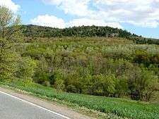
Rigaud's land area is 99 km². The relief is composed, on the North side, of the Ottawa River plain and, on the South side, of Mount Rigaud. The Ottawa River and Mount Rigaud are the main elements in the landscape. The plain is partly used for agricultural purposes and partly in bush. Mount Rigaud covers an area of 47 km². A lot of rock pieces scatter the woods all over the mountain. It is a moraine shaped by a glacier that, by moving, broke up from the bedrock of the Canadian Shield, fragments that it disaggregated and rounded by rolling over them, moving them and leaving them in this basin, some thousand years ago, at the end of the Wisconsin glaciation.
Demographics
Population
| Canada census – Rigaud, Quebec community profile | |||
|---|---|---|---|
| 2011 | 2006 | ||
| Population: | 7,346 (+8.3% from 2006) | 6,780 (+11.2% from 2001) | |
| Land area: | 99.12 km2 (38.27 sq mi) | 99.08 km2 (38.26 sq mi) | |
| Population density: | 74.1/km2 (192/sq mi) | 68.4/km2 (177/sq mi) | |
| Median age: | 45.1 (M: 44.8, F: 45.4) | 43.4 (M: 42.9, F: 43.8) | |
| Total private dwellings: | 3,254 | 2,923 | |
| Median household income: | $56,775 | $48,332 | |
| References: 2011[5] 2006[6] earlier[7] | |||
|
|
|
Language
| Canada Census Mother Tongue – Rigaud, Quebec[8] | ||||||||||||||||||
|---|---|---|---|---|---|---|---|---|---|---|---|---|---|---|---|---|---|---|
| Census | Total | French |
English |
French & English |
Other | |||||||||||||
| Year | Responses | Count | Trend | Pop % | Count | Trend | Pop % | Count | Trend | Pop % | Count | Trend | Pop % | |||||
2011 |
7,260 |
5,615 | 77.34% | 1,225 | 16.87% | 125 | 1.72% | 295 | 4.06% | |||||||||
2006 |
6,605 |
5,120 | 77.52% | 1,160 | 17.56% | 55 | 0.83% | 270 | 4.09% | |||||||||
2001 |
5,940 |
4,740 | 79.80% | 965 | 16.24% | 60 | 1.01% | 175 | 2.95% | |||||||||
1996 |
5,930 |
4,805 | n/a | 81.03% | 845 | n/a | 14.25% | 70 | n/a | 1.18% | 210 | n/a | 3.54% | |||||
Attractions
Rigaud Mountain
The main attraction is Mont-Rigaud, a hill with downhill ski runs (at Ski Mont Rigaud), a private school (Collège Bourget), a monastery, and a shrine dedicated to the Virgin Mary (Sanctuaire Notre-Dame-de-Lourdes). The mountain is also home to an unusual, natural rock garden known as the "champs de patates", so named because of the local legend that it was once a potato field, turned to stone by God because the farmer worked on Sunday. On the opposite side of the mountain is a residential community known as "Mountain Ranches." The middle to upper-middle class community features large, mostly secluded building lots in a wooded setting that draws residents because of its isolated tranquility and privacy. As such, it was the hiding place for fugitive Charlie Wilson, one of the leaders of the notorious 1963 Great train robbery in England.
This area was also known for its "tree farms" in the 1960s and 1970s, providing a tax shelter for the well off, until the tax laws were later changed to require harvesting of those "tree farms". The "Pitcairn Tree Farm", was one such example.
Also located in Rigaud is the training center for the Canada Border Services Agency.
The communities of Dragon and Rigaud are found within the city.
Transportation
The Rigaud station was the former terminus of the AMT commuter train to downtown Montreal.
On 1 July 2010, service to Rigaud was discontinued, as the town was unable to pay the $300,000 annual fee to the AMT to allow service to continue to the town. After that date, the rail line ends at Hudson.[9]
The town is served by the 61 bus from Exo La Presqu’Île.
Education
Commission Scolaire des Trois-Lacs operates Francophone schools.[10]
- École de l'Épervière
- Some areas are served by École Sainte-Marthe in Sainte-Marthe[11]
Lester B. Pearson School Board operates Anglophone schools.[12]
- Soulanges Elementary School in Saint-Télesphore or Evergreen Elementary and Forest Hill Elementary (Junior Campus and Senior campus) in Saint-Lazare
See also
- List of cities and towns in Quebec
References
- Reference number 311423 of the Commission de toponymie du Québec (in French)
- Ministère des Affaires municipales, des Régions et de l'Occupation du territoire: Rigaud
- Parliament of Canada Federal Riding History: VAUDREUIL—SOULANGES (Quebec)
- 2011 Statistics Canada Census Profile: Rigaud, Quebec
- "2011 Community Profiles". 2011 Canadian Census. Statistics Canada. 5 July 2013. Retrieved 21 February 2014.
- "2006 Community Profiles". 2006 Canadian Census. Statistics Canada. 30 March 2011. Retrieved 21 February 2014.
- "2001 Community Profiles". 2001 Canadian Census. Statistics Canada. 17 February 2012.
- Statistics Canada: 1996, 2001, 2006, 2011 census
- Montreal Gazette: "All aboard for the last train to Rigaud", April 23, 2010.
- "Les écoles et les centres". Commission Scolaire des Trois-Lacs. Retrieved 18 January 2013.
- "Liste des bassins desservis par les écoles en 2017–2018." Commission Scolaire des Trois-Lacs. Retrieved on 30 September 2017.
- "School Board Map." Lester B. Pearson School Board. Retrieved on 28 September 2017.
External links
| Wikimedia Commons has media related to Rigaud, Quebec. |
Adjacent Municipal Subdivisions | |
|---|---|
| Cities & towns | |
|---|---|
| Municipalities | |
| Villages | |
| |
| |
| Quebec City area: | |
| Montreal local area: |
|
| Laurentides area: Montreal-area Laurentians |
|
| Eastern Townships: |
|
| Gatineau area: Ottawa-area Laurentians |
|
| Lanaudière area: Montreal-area Laurentians |
|
| Saguenay–Lac-Saint-Jean |
|
| |