List of car-free places
The areas in this list of car-free places make up a sizeable fraction of a city, town, or island; public transport connections do not in themselves constitute a car-free area.
Color-coding is used as follows:
| Place name | Most or all of the area is essentially car-free |
| Place name | Large area that is nearly car-free |
| Place name | A limited number of vehicles intrude |
Austria
| Location | Area | Population | Character |
|---|---|---|---|
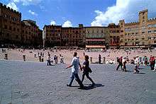
| Vienna | Central parts of Innere Stadt are a sizable car-free zone around St. Stephens Cathedral | 16 944 people | The historic center of Vienna including the main shopping streets, Graben and Kärntner Straße. Stephansplatz, Freyung, Minoritenplatz and Judenplatz are among the most important medieval squares of the area. |
| Autofreie Mustersiedlung Floridsdorf housing project | 250 units | New car-free residential project, organized by Green party | |
| The rather broad main shopping street Mariahilferstraße is in large part a Begegnungszone | 20 km/h-slow cars on a narrow middle lane meet pedestrians; expansion realized 2015 after dispute under Maria Vassilakou (Green Party) | ||
| Columbusplatz in a southern outer district | 20 km/h-slow cars on a narrow middle lane meet pedestrians; expansion realized 2015 after dispute under Maria Vassilakou (Green Party) | ||
| Linz | central axis and shopping street Landstraße to Hauptplatz interrupted by several crossing streets | carrying the streetcar, cycling (partially?) allowed after decades of prohibition | |
| Graz | Several streets in the old town | Significant pedestrian zones and car-free shopping areas; streetcar in main axis Herrengasse–Hauptplatz–Sackstraße cycling prohibited in Herrengasse (but allowed from 20 to 08 o clock since about 2013) and some small streets, parallel Schmiedgasse is narrow official cycle main route | |
| part of Europaplatz in the south and east of the main entrance to railway main station | forecourt is partially sheltered by a ring "Golden Eye" used by pedestrians to trains, local to international buslines, streetcars underneath, general food store (6 am to 10 pm) and other stores in the main station, cycle path with roofed cycle storage facility, all the construction work finished in about 2014 | ||
| Wels | half of central historical Stadtplatz, rectangular axis Schmidtgasse–Bäckergasse crossed by the street Ringstraße and leading to Kaiser-Josef-Platz | Oldest and central part of the town since the Romans, three parallel shopping streets connected by a comfortable walkable smaller axis, the importance of gastronomy is rising | |
| Feldkirch | Historic center | Oldest part of Feldkirch bordering the Ill river includes hotels, shopping, St. Nikolas Cathedral, City Hall, the Katzenturm, and the historic castle Schattenburg | |
| Salzburg | A number of streets in the medieval center are car-free | Lovely old town with significant car-free shopping areas | |
| Klagenfurt | Alter Platz in the old center and a network of surrounding smaller streets and places, the rectangular area in the middle of the large Neuer Platz following in the south | the big space around monument Lindwurm on Neuer Platz is paved or sanded, Kramergasse is said to be the first pedestrian zone of Austria | |
| other towns: | the country (Bundesland) capitals: Bregenz, Eisenstadt, Innsbruck, St. Pölten | further: Amstetten, Baden, Bludenz, Bruck/Leitha, Gmünd (NÖ), Kitzbühel, Krems, Landeck, Leoben, Lienz, Mödling, Mürzzuschlag, Tulln, Villach, Wr. Neustadt, Wolfsberg, Zell am See.[1] | |
Belgium
| Location | Area | Population | Character |
|---|---|---|---|
| Antwerp | Some of historic centre | Shopping district in historic centre is car-free; see Meir, the main shopping street | |
| Brussels | Most of historic centre | The second-largest car-free area in Europe; most streets surrounding Grand Place and Brussels Stock Exchange area are car-free, as well as major shopping street Rue Neuve | |
| Liège | Most of historic centre | the oldest car-free area in Belgium, see Liège § Main sights | |
| Louvain-la-Neuve | Most or all of the city | 29,521 | University town; surface is car-free; streets and parking are below pedestrian streets |
| Ghent | Entire city heart | 260,341 | Second-largest car-free area in Belgium; public transport, taxis and permit holders may enter but not exceed 20 km/h |
| Hasselt | Most of the historic centre | Most streets inside the "Groene Boulevard" are car-free or very low traffic. | |
| Kortrijk | Shopping area | First car-free shopping street in Belgium; nowadays extended with parts of the centre | |
| Leuven | Large parts of centre | Two types of pedestrian zone. Some exceptions (at certain time periods) for suppliers, public transport, medical vehicles, residents... | |
Bosnia and Herzegovina
| Location | Area | Population | Character |
|---|---|---|---|
| Baščaršija | Old part of Sarajevo | 100% of the Old City is entirely free of motorized vehicles. |
Bulgaria
In Bulgaria almost every city or town has pedestrians-only zone, usually in downtown.
| Location | Area | Population | Character |
|---|---|---|---|
| Blagoevgrad | Downtown | This small university town of 60,000 contains a quite substantial pedestrian area, with one long walking street and several smaller ones, in addition to two large and one extremely large car-free squares. | |
| Burgas | Downtown | An important coastal city (roughly 200,000 inhabitants), Burgas has two main pedestrian boulevards perpendicular to each other. | |
| Pazardzhik | Downtown | A medium-sized Bulgarian city (roughly 80,000 inhabitants) contains a proportionately large pedestrian network, where in one instance five pedestrian streets intersect. | |
| Plovdiv | Downtown | Bulgaria's second-largest city (roughly 340,000 inhabitants in the city and 600,000 in the urban area) contains one of the largest pedestrian streets in Europe. | |
| Ruse | Downtown | The "Little Vienna", as it is called, has a significant pedestrian-only zone with streets and squares. | |
| Sofia | Downtown | The capital of Bulgaria's central thoroughfare, Vitosha Boulevard, was transformed into a vibrant pedestrian-only zone in the 2010s. | |
| Sunny Beach | Beachfront | Sunny Beach's main beachfront promenade, as well as its central street, are pedestrian zones. | |
| Sveti Vlas | Downtown | St. Vlas's main street is closed to traffic during the summer tourist season. | |
| Sliven | Downtown | 95.000 | Sliven's main street is a pedestrian-only and includes several squares. |
| Yambol | Downtown | 75.000 | Yambol has two parallel closed for all types of vehicles streets (bicycles are only allowed), connected with small streets, parks and squares between them. The main one, starts from a city park, which is located on an island in Tundja river. The city park is also pedestrians only zone. |
| Velingrad | Downtown | A small spa resort, Velingrad features a pedestrian-only main street. | |
Croatia
| Location | Area | Population | Character |
|---|---|---|---|
| Dubrovnik | Old City | 100% of the Old City is entirely free of motorized vehicles. | |
| Split | Old City | Diocletian's Palace and adjoining areas to the west are free of cars. | |
| Zlarin | Entire island (8.19 km2) | 276 | Only service vehicles and tractors are allowed.[2] Several electrically powered golf carts are also used.[2] |
| Prvić | Entire island (2.37 km2) | 453 | Only service vehicles and tractors are allowed. Approximately two electrically powered golf carts are also used. |
| Koločep | Entire island (2.3 km2) | 120-200 | Approximately two electrically powered golf carts are used apart from a few mopeds. |
| Silba | Entire island (15 km2) | 292 | Only service vehicles and tractors are allowed. Mailman also uses a moped.[3] |
Czech Republic
| Location | Area | Population | Character |
|---|---|---|---|
| Prague | Large car-free area starting at Old Town Square and extending across the river | Medieval quarter | |
| Tábor | Modest network of car-free streets | Old town | |
| Poděbrady | Town center is free of cars and bicycles | Spa town with mineral water |
Denmark
| Location | Area | Population | Character |
|---|---|---|---|
| Strøget, Copenhagen | Large downtown car-free shopping area | Central Copenhagen is one of the largest and oldest examples of auto-free zones, heavily used, much tourist traffic. Street lights are hung from cables attached to building walls which leaves the walks unimpeded by obstructing posts. The city's bicycle paths are extensive and well-used. | |
| Christiania community, Copenhagen | former Bådsmandsstræde barracks and part of city ramparts | 850 | Several streets with recycled and ad-hoc buildings. |
| Ertholmene, Bornholm | Entire island is car-free | 96 | Easy for walking. Passenger car-free ferry arrive to there, from Bornholm. |
Finland
| Location | Area | Population | Character |
|---|---|---|---|
| Suomenlinna | 0.8 km² island | 850 | car-free fortress in Helsinki, service traffic allowed. |
| Turku | Several streets in the heart of the city | Shopping street Yliopistonkatu and large parts of the streets siding the Aura River are only for pedestrians and bicycles, service traffic allowed during low-traffic hours. Riversides connected with several pedestrian-only bridges and the free-of-charge pedestrian-only ferry Föri. |
France
| Location | Area | Population | Character |
|---|---|---|---|
| Avoriaz | Car-free ski resort | ||
| Mont Saint-Michel | 4 km² island | about 60 | Car-free fortress/abbey |
| Île-d'Aix | Entire island (1.19 km²) is car-free. | 219 | Easy for walking/biking[4] |
| Île de Porquerolles, near Toulon | Entire island is car-lite and many areas car-free. | 5000 (summers) | Resort. Non-residents are not allowed to have cars. |
| Île de Sein, Bretagne | Entire island (0.58 km²) is car-free | 214 (summer:1.500) | Easy for walking[5] |
| Île de Bréhat, Bretagne | Entire island (3.09 km²) is car-free | 444 (summer:10000) | Easy for walking/biking[6] |
| Île de Hoedic, Bretagne | Entire island (2.08 km²) is car-free | 111 | Easy for walking/biking[7] |
| Île de Houat, Bretagne | Entire island (2.91 km²) is car-free | 311 | Easy for walking/biking[8] |
| Île de Batz, Bretagne | Entire island (3.05 km²) is car-free | 594 | Easy for walking/biking |
| Île-Molène, Bretagne | Entire island (0.75 km²) is car-free | 211 | Easy for walking[9] |
| Archipel du Frioul, near Marseille | All four islands (400 ha) are car-free | 86 | Easy for walking[10] |
| Île d'Yeu, Vendée | Large car-free center | 5000 (summer:40000) | Easy for walking/biking |
| Lille | Area near the Grand Place | Shopping district | |
| Lyon | Rue de la République, Rue Victor-Hugo, and side streets | 17th-18th-century mixed-use six-storey area | |
| Lyon | Part of Vieux Lyon | Medieval quarter | |
| Nice | Almost all of Vieux Nice and other adjacent areas | Historic city centre and it surroundings | |
| Port Grimaud | Large car-free center | Resort | |
| Quartier de l'horloge, Paris | Area north of the Pompidou Center (1.2 ha) built in the 1980s + the parvise of the Pompidou Center, car-free | 200? | Modern large-scale development |
| Les Halles, Paris | Redeveloped market area | ||
| Quartier Montorgueil, Paris | |||
| Dijon | Small car-free center | Old buildings on narrow streets | |
| Strasbourg | Part of the old town | Medieval core | |
| Colmar | Town Center | Large historic pedestrian area in center of town | |
| Chambéry | Significant car-free area | Medieval quarter | |
| Montpellier | Many car-free streets | 11,000 in the medieval quarter | Center of medieval university town |
| La Rochelle | Car-free area and anti-car policies | 80,000 (entire city) | |
| Tours | Several blocks of the medieval old town are restricted to pedestrians only | Old medieval center | |
| Bordeaux | Some streets | Morning truck deliveries permitted; limited car access for residents | |
| Sarlat | Old part of city | Reportedly car-free and pedestrian friendly except for central main street | |
| Lauzerte | Place des Cornières | Car-free; bike and pedestrian only | |
| Yvoire | Old part of city | Medieval quarter |
French cities planning to ban diesel and petrol vehicles: Paris (diesel by 2024 and petrol by 2030).[11]
Germany
| Location | Area | Population | Character | |
|---|---|---|---|---|
| Augsburg | Sections of the centre | Main shopping areas of downtown Augsburg | ||
| Berlin | Spandau | Altstadt Spandau | pedestrian shopping area with access via ubahn. | |
| Cologne | Old city | Area around the cathedral and main shopping areas. Access to the riverbank as well. | ||
| Düsseldorf | Altstadt and the banks of the Rhine | Some shopping, many bars and restaurants | ||
| Düsseldorf | Schadowstrasse and Wehrhahn | Shopping. Wehrhahn still under construction at time of writing | ||
| Essen | City center, Kettwiger Straße, Limbecker Straße and many smaller Streets in the Center of the City | Large shopping area connecting the train station to Limbecker Platz, with its shopping mall | ||
| Erfurt | Historic center | |||
| Frankfurt | City center | Area around the Zeil and the old opera house. Extends down to the river with pedestrian bridges to the large parks on the other side | ||
| Freiburg im Breisgau | Large car-free center (610 x 720 m) | perhaps 10,000 | Medieval university town; minimal car traffic is permitted on some streets; trams provide access. Progressively pedestrianised since 1971.[12] Widely seen as a pioneer of "car-free"/people oriented development. | |
| Freiburg im Breisgau | Vauban district | 5,000 | New district converted from a military base; car parking distributed, trams provide access | |
| Erlangen | Former US-Army area/Hartmannstrasse | some 2.000 | Car parking concentrated in some multi-storey car parks | |
| Erlangen | Bonhoefferweg-Siedlung | some 200 | Car parking outside the residential area | |
| Leipzig | Petersstraße | |||
| Lindau | Historic center | |||
| Munich | 7 km of car-free streets | |||
| Nürnberg | 9 km of car-free streets | |||
| Potsdam | Historic center | |||
| Rothenburg ob der Tauber | 13,000 | Nearly the entire city | ||
| Rostock | Historic center | |||
| Wittenberg (Gartenstadt Piesteritz) | 1,200 | Development c. 1915; newly car-free (1994—1999)[13] | ||
| Nürnberg - Langwasser | 3,180 | New development (1978–1987) | ||
| Hamburg (Stadthaus Schlump) | Small | 45 dwelling units | car-free mixed-use conversion of an old hospital | |
| Hamburg (Saarlandstraße) | 210 dwellings | New development (2000)[14] | ||
| Bremen (Grünenstraße) | 800 m² | 23 dwellings | New development | |
| Schwerin | Historic center | |||
| Stuttgart | 6.9 km of car-free streets | |||
| Niederrathen | Entire village | 500 | Village in Saxony | |
| Lechbruck am See | resort facilities | Small part of village in Bavaria (car allowed on Saturday) | ||
| Hayingen | Entire village | 105 houses | Village in Swabia | |
| Tübingen (French Quarter) | Some parts of redevelopment car-free | |||
| Tübingen (converted military base) | 6000 residents, 2000 jobs | |||
| Frauenchiemsee | 15.5 ha | 300 residents | island in lake Chiemsee, historic abbey | |
| Munich (Messestadt Riem) | 41 dwellings | car-free part of a larger new development[15] | ||
| Münster (Geist) Gartensiedlung Weissenburg | 184 dwellings | New development (2001)[16] |
.png)
German islands and resorts
(Residents are allowed cars on some islands)
| Location | Area | Population | Character |
|---|---|---|---|
| Heligoland | Entire island | 1650 | North Sea Island. In addition to cars, bicycles are banned. |
| Baltrum | Entire island | 510 | East Frisian Island |
| Spiekeroog | Entire island | 730 | East Frisian Island |
| Langeoog | Entire island | 1970 | East Frisian Island |
| Wangerooge | Entire island | 1180 | East Frisian Island |
| Juist | Entire island | 1790 | East Frisian Island |
| Hiddensee | Entire island | 1200 | Baltic Sea Island |
| Gröde and Nordstrandischmoor | North sea islands | total of 30 inhabitants | North Frisian Islands |
Greece

| Location | Area | Population | Character |
|---|---|---|---|
| Hydra Island | Entire island (50 km²) | 3,000 | No motorized vehicles on the entire island |
| Lindos/Rhodes | Entire Town | Motorized traffic impossible due to narrow streets | |
| Mount Athos | Entire Peninsula | 1,400 | Motorized traffic of non residents is prohibited. Local traffic is extremely limited with only some vehicles used by the monastic community for essential communication, and transportation needs |
Hungary
| Location | Area | Population | Character |
|---|---|---|---|
| Budapest | Margaret Island | 3 | Entry by cars forbidden except for a single bus line and taxis; service traffic of local stores and restaurants are allowed to enter |
Italy
| Location | Area | Population | Character |
|---|---|---|---|
| Venice | Entire city, except at the bus station square | Estimated at 50,000 | Medieval city, today highly focused on tourism; transport on foot or by water |
| Capri | Eastern part of the island, about 20% of overall area | Island resort, car-free area includes the main city centre with shopping roads and major high-class hotels | |
| Siena | Historical city center | Most streets have little traffic | |
| Cinque Terre (5 towns on the Gulf of Genoa) | Most of each town | Towns are car-moderated | |
| Como | Within the medieval city walls | 6,200[17] | Areas of the historic center inside the medieval walls. Delivery trucks and residents can apply for permits. Enforced by means of cameras automatically verifying plates of cars both at the entrance and at exit at permitted gates. |
| Lipari Islands | Stromboli, Ginostra, parts of Lipari village centre, other remote places | ||
| Chamois | Entire village | 96 | |
| Orta San Giulio | Entire town is car-free; visitors may park in lots above the town and continue down by foot | 1177 | Medieval village on the shore of Lake Orta in the Piedmont region |
| Monte Isola | Entire village | 1.768 | |
| Lucca | Within the city walls mainly car-free | Medieval town | |
The Netherlands
| Location | Area | Population | Character |
|---|---|---|---|
| Amsterdam GWL project | 600 unit car-free residential area | About 1,500 | Modern architecture on the site of a disused waterworks; some car parking at the edge |
| Delft | Most of the old center | Medieval center | |
| Giethoorn | old part of town | About 2,500 | Transport by canal boat, bicycle or by foot in this area |
| Groningen | Most of the old city center | 16,551 within the City Centre[18] | Much of the City Centre is pedestrianized. The City Centre has no through routes for motor traffic; much of it is pedestrianized |
| Houten | Entire town designed to favor cyclists | 38,062 | Sustainable urban design encourages people to travel by bike and train. Chosen as Dutch "Bicycle-city 2008" |
| Kalverstraat/Nieuwendijk, Amsterdam | Long main shopping street with many narrow side streets | Unknown; primarily commercial | Shopping district; delivery vehicles allowed in AM |
| Islands of Schiermonnikoog and Vlieland | Entire islands | About 1,000 residents on each plus many tourists in season | Only residents are allowed to bring cars onto the islands |
| Tiengemeten | Entire island | About 10 | Island that is almost entirely given back to nature, only some vehicles of staff and residents allowed |
| Orvelte | Entire town | About 230 | This is a town and museum in one. The 230 residents live inside the museum village. Parking is on the outskirts of the village. |
Poland
| Location | Area | Population | Character |
|---|---|---|---|
| Kraków | A large area of the Old Town Square encircled by a park known as Planty is accessible by automobile only to residents, taxis, police, service vehicles, and delivery vehicles (so that, in fact, plenty of motor traffic occurs). | 5,345 (Old Town in 1998) | Old town |
| Poznań | Sections of the Old Town | ||
| Toruń | Old town | Old town, a World Heritage Site, is mostly car-free | |
| Warsaw | Old Town, New Town, Krakowskie Przedmieście, and Chmielna are largely closed to private cars (except for residents, for example) | ||
| Wrocław | Sections of the Old Town | ||
| Zakopane | |||
| Zielona Góra | |||
| Złotów |
Portugal
| Location | Area | Population | Character |
|---|---|---|---|
| Óbidos | Entire area of walled town | Around 3,100 | Medieval walled hill town (now tourist area); only residents permitted to drive into the town, although cars are a nuisance |
| Aveiro | Many small streets | 75,000 | Praça do Peixe, a large pub area and the judicial city |
| Baixa, Lisbon | One long shopping street, with a few side streets | 18th-century 5-story mixed use | |
| Santarém | Most of the streets in the oldest part of town | 64,124 | three-storey, old, mixed use area |
| Faro | Some of the downtown area | 6 to 8 old streets that form a small network in the center of town | |
| Tavira | Some of the old downtown | Narrow, winding streets in the old part of town. | |
| Évora | Several streets and a couple of squares in the old walled city | 8500 (in the walled city) | The squares of Giraldo and Sertório plus a number of commercial streets. |
| Coimbra | Many small streets | Old medieval quarter | |
| Viseu | A number of narrow streets in the town center | Largely intact medieval city; on Fridays, the entire old center is car-free | |
| Porto | A number of streets downtown | Streets are only closed to cars on the weekends [19] | |
Romania
| Location | Area | Population | Character |
|---|---|---|---|
| Băile Felix | Central area around the hotels and thermal lakes | Thermal spa resort. The whole central area hosting parks, thermal lakes, churches and hotels is closed to vehicular traffic. | |
| Craiova | The historic centre. | Pedestrian shopping street, cafes, restaurants, bars. | |
| Mamaia | About 5 km car-free esplanade on the Black Sea shore. | The biggest beach summer resort on Romanian Black Sea shore featuring shops, art galleries, cafés, festivals, restaurants, beach bars, night clubs, pools. | |
| Oradea | Republicii Street | Pedestrian shopping street with many restaurants, cafés, statues | |
| Central square, Alexandri Street and surrounding area | Tourist area with some of the city's main attractions, many cafés, restaurants and night clubs. It includes an indoor pedestrian walkway in the Black Eagle Palace that is a landmark of the city. | ||
| Timișoara | Some of the central area | Pedestrian shopping street, cafés, restaurants, bars. | |
Russia
| Location | Area | Population | Character |
|---|---|---|---|
| Moscow | Old Arbat Street is a picturesque pedestrian street. | Tourist area | |
| Moscow Kremlin - UNESCO World Heritage Site, Entire area of walled town. | Cars are allowed only during parade | ||
| Luzhniki Olympic Complex. | about 10000 in non-transit area | Three areas: walled pedestrian transit area nearby Luzhniki Metro Bridge (24 hours access except events), another walled area open 10 to 22, access most times free of charge, authority area to cars northern to the stadium (northern border is transit road – Khamovnichesky Val) with public transport. Also, there is a non-transit area nearby to the metro Sportivnaya. | |
| White House, Moscow - after 1993 building zone, pedestrian zone and car zone were divided, transit cars were diverted to embarks, local cars to adjustment streets. | N/A | ||
| VDNKH - On the week days cars may go only with special permission, like big yard mode (speed limit 10 km/h, to service and buses 20 km/h). On the weekends only public transport is allowed unless any car is in zone with pavilions 69-70-75. | N/A | ||
| Saint Petersburg | Large parts of the city. | City with numerous canals running throughout its centre with equally numerous car-free zones in and around those areas. | |
| Nizhny-Novgorod | Large central street near the Kremlin, as well as parts of the Kremlin itself. | ||
| Kazan | Kazan Kremlin, and a large main street (Bauman Street, pedestrian-only since 1986) going from the Kremlin to the city centre. | ||
| Yekaterinburg | Weiner Street is a picturesque pedestrian street. | Shopping and tourist area |
Serbia
| Location | Area | Population | Character |
|---|---|---|---|
| Knez Mihajlova | 1 km | Knez Mihailova Street features a large number of impressive buildings and mansions built during the late 1870s. It was declared Spatial Cultural-Historical Units of Great Importance in 1979, and it is protected by Republic of Serbia. Location of Serbian Academy of Sciences and Arts, and numerous other institutions. | |
| Tešnjar | one street that follows the river course Kolubara and several smaller streets below the hill | Old Serbian urban settlement, mostly originated in the 19th century. Unique example of old architecture in the interior of Serbia. Located on the right bank of Kolubara a long time was a trade center of Valjevo. | |
| Tinkers Alley | one short street in the city center | Also known as Coppersmith alley (Serbian: Kazandžijsko sokače, Казанџијско сокаче). An old urban downtown which was built in the first half of the 18th century. It was a street full of tinkers and other crafts, together with craftsmen houses deriving from Turkish period.[20] | |
Slovenia
| Location | Area | Population | Character |
|---|---|---|---|
| Ljubljana | Slow-moving taxis ("Kavalir") provide free rides for the elderly, pregnant people, and others. | ||
Spain
| Location | Area | Population | Character |
|---|---|---|---|
| Málaga | 3,900 m² car-free and limited access streets | Moorish and 19th-century historic center | |
| Seville | Santa Cruz district has many narrow, car-free streets | Medieval/Renaissance quarter | |
| Bilbao | Casco Viejo (Old Town) district has narrow streets with limited car access | Medieval quarter | |
| Vitoria-Gasteiz | Most of the old walled city, as well as most of the "Ensanche" streets | Medieval quarter and 19th-century center | |
| Madrid Puerta del Sol | 6 blocks square (limited car access) | Busy central area | |
| Salamanca | Entire Medieval city including old Roman bridges | Plaza mayor and entire old city. | |
| Segovia | Large parts of the old, walled city | Medieval area | |
| Pontevedra | Large central pedestrian zone | Whole old town, narrow streets and small squares. Almost no cars. | |
| Leon | Large central pedestrian zone | Whole old town, narrow streets and small squares. Almost no cars. | |
| Burgos | Large central pedestrian zone | Most of the old town, narrow streets and some squares. The old town is entirely car-lite, and much of it is carfree except for deliveries. | |
| Santiago de Compostela | Large central pedestrian zone | ||
| Ayamonte (in S.W. corner) | Downtown commercial district | Old medieval quarter with very narrow streets; river town on the flanks of a hill | |
| Barri Gòtic, Barcelona | A number of car-free streets, others car-light | 27,946[21] | Medieval center |
| Girona | Rambla (promenade and shopping street) and network of narrow residential streets | Historic centre | |
| Granada | Albaicin neighborhood (limited car access on a few streets) | Historic Moorish quarter | |
| Laguardia (Biasteri) photos | |||
| Valladolid | Central square and surrounding streets. | Historic centre, although most buildings are now modern. |
Sweden
| Location | Area | Population | Character |
|---|---|---|---|
| Gamla stan, Stockholm (Old Town) | Most of the old heart (c. 0.3 km²) | 3000 | Oldest part of the city; medieval area; low traffic in central parts of the Old Town during part of the day, AM deliveries allowed and taxis allowed 24 h; there is no supervision and no control, so in reality and for all practical considerations the area can't be considered car-free. |
| Malmö | Large pedestrian precinct | City center; further expansion planned | |
| Växjö, Sweden | Entire city center | car-free district in fossil-fuel reduced city (external link) | |
| Jakriborg | Entire village | 2000-5000 | Newbuilt suburb/village in old style, connected to Malmö and Lund via rail. |
| Southern Göteborg Archipelago | Archipelago including Vrångö, Brännö, Styrsö, and Vargö | 5,000 permanent, another 6,000 summer | West of Gothenburg |
Switzerland
| Location | Area | Population | Character |
|---|---|---|---|
| Zermatt | Entire town | 5687 | car-free Alpine resort with prototype "Utility Area" at the entrance; slow electric taxis and freight vehicles used, although these are sometimes driven at higher speeds |
| Bettmeralp | Entire town | Alpine resort, sometimes considerable traffic of utility vehicles | |
| Braunwald | Entire town | 398 | Alpine resort |
| Riederalp | Entire town | 555 | Alpine resort |
| Rigi | Entire mountain | Mountain resort, some utility vehicles | |
| Saas-Fee | Entire town | 1607 | Alpine resort; small electric utility vehicles |
| Stoos | Entire town | Alpine resort; small electric utility vehicles, mainly from the resorts hotels. | |
| Wengen | Entire town | 1400 | Alpine resort |
| Zürich | Large parts of the old town | Car-free medieval urban core. (Taxis and cars with special permits are allowed) | |
| Lausanne | Large parts of the old town | The lower mediaeval part of the old town is car-free. Cars are allowed but uncommon in the upper ancient part. Taxis are allowed. | |
| Geneva | Ten streets | 10,000 | car-free areas in the heart |
| Basel | Parts of the medieval town are car-free | The city is heavily dependent on an excellent tram system and most of the center city is highly car moderated if not car-free | |
| St. Gallen | Old center | car-free | |
| Neuchâtel | Old center | car-free | |
| Appenzell | Old center | car-free | |
| Gstaad | Village center | car-free | |
| Gruyere | Village center | Reportedly significant car-free area | |
| Rapperswil | Medieval center | car-free center | |
| Brig | Perhaps ten blocks in downtown | Old part of the city, mixed use | |
| Winterthur | Historic center | ||
| Lugano | Most of the old quarter | ||
| Mürren | Entire town | 450 | Alpine resort; some utility traffic |
| Gimmelwald | Entire town | 130 | Small village |
| Bern - Halen | 79 apartments | Terraced neighborhood; built 1961; parking at edge | |
| Siedlung Burgunder (german overview & ZDF-clip) | 40 apartments | housing estate, built until 2010 | |
| Boll-Sinneringen (Vechigen) - Wohnanlage Schloßpark | 73 apartments | Built 1996; parking at edge | |
Turkey
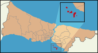
The Prince's Islands near Istanbul do not permit cars (aside from public service and emergency vehicles such as police, garbage, electricity etc.), meaning the only other forms of transport are by foot, bike, or horse carriages. Four of these islands can be reached by ferry from Istanbul, which takes about an hour.
| Location | Area | Population | Character |
|---|---|---|---|
| Büyükada | 7,320 | Almost entirely car-free. | |
| Heybeliada | 3,000 | Almost entirely car-free. | |
| Burgazada | 1,500 | Almost entirely car-free. | |
| Kınalıada | 1,500 | Almost entirely car-free. | |
UK and Channel Islands
| Location | Area | Population | Character |
|---|---|---|---|
| Island of Sark (Channel Islands) | Whole island | 560 | Entirely car-free (only motorized vehicles are tractors) |
| Island of Herm (Channel Islands) | Whole island | 60 | Cars and bicycles are both banned (quad bikes are allowed, but only for maintenance) |
| Birmingham | City centre | Victoria Square, Chamberlain Square, Centenary Square, Brindleyplace, New Street, High Street, Needless Alley, Cannon Street, Temple Row. Cherry Street and Union Street. | |
| Chester | Some of city centre | Some central streets pedestrianised in the 1990s, proposal for expansion as of 2014[22] | |
| Cambridge | City centre and university campus | Several thousand | University town with heavy tourism; cars banned most of the day from centre |
| Oxford | Some areas in city centre | 11,786 (city centre wards) | Medieval university town with heavy traffic through it. Cornmarket Street, Radliffe Square surrounding the Radcliffe Camera and University Church of St Mary the Virgin, and Brasenose Lane are pedestrian only; Queen Street is bus only; many surrounding streets have restricted vehicular access. Pedestrian streets are surrounded by heavy traffic, including many buses, and pavements are at times no wider than a metre. There are plans to extend this to the entire city centre (with the exception of electric vehicles) by 2035. |
| Salisbury | City centre and cathedral close | 40,302 | Parts of the town centre are car-free, including some of the Cathedral Close |
| Canterbury | City centre (approx. historic, walled city area) | several thousand (historic centre) | Canterbury's historic city centre has been closed to most motor vehicle traffic for several decades. A ring road which was built in the 1960s, when Canterbury saw rapid growth in buildings and population, is used as the perimeter for the boundary. Cars are allowed only during certain times of the day and the city's road system is designed to discourage "rat runs". |
| York | Part of the city centre is car-free (approx 400 x 400 m) during the day | Restricted access for deliveries; disabled car access and parking is maintained. | |
| Leeds | Entire city centre shopping district centred on Briggate (approx 400 x 400 m) | Pedestrian precinct (access for delivery to some areas allowed between 23:00 and 06:00 hours). | |
| Lincoln | Several cobbled streets around Lincoln Cathedral | Car-free area near the centre. | |
| Isles of Scilly | Group of islands off Land's End | Combined population of 2000 | Islands of Bryher, Tresco, St Agnes and St Martin's are car-free |
| Clovelly | Village in North Devon | 1600 | Entirely car-free |
| Shrewsbury | Several streets in town centre | Medieval town enclosed within loop of River Severn. Pride Hill entirely motor-vehicle free except limited access for loading in mornings. The Square, Fish St (2m width restriction), Butcher Row allowed for access and delivery only. 2009 closure of Music Hall removed much access/delivery traffic from The Square. Grope Lane and the "shuts" too narrow for traffic. | |
| Edinburgh | Some of city centre | Slateford Green car-free development, High street on the Royal Mile between George IV Bridge and South Bridge. Rose Street is also pedestrianized. | |
| Easdale | Whole island | 59 | Entirely car-free |
| Cardiff | Most of the city centre (approx 500x500m) | Most of Central Cardiff is car-free, including Queen Street, The Hayes, High Street and parts of St Mary Street. Around 2.7 km of connected pedestrian streets. There are also several arcades (covered streets) in the city centre. |
Ukraine
| Location | Area | Population | Character |
|---|---|---|---|
| Lviv | Old town | Old town, a World Heritage Site, is mostly car-free | |
| Kiev | Kontraktova square | Kontraktova square and two blocks of Sagaidachnogo street are car-free since August 2017. Reconstruction of the area is planned for 2018 in order to make it pedestrian friendly. | |
| Odesa | Derybasivska Street | ||
| Poltava | Sobornosti street | Central 350m stretch of the street is pedestrian | |
| Zhytomyr | Teatralna street | Half of the street is pedestrian |
Baltic and Balkans
| Location | Area | Population | Character |
|---|---|---|---|
| Dubrovnik, Croatia | The old walled city | Nearly car-free | |
| Rovinj, Croatia | The old town is reported to be largely or entirely car-free | Undoubtedly medieval | |
| Vilnius, Lithuania | Large car-free area reported | One of the largest surviving medieval quarters in Europe | |
| Kaunas, Lithuania | Laisves Aleja | A double tree-lined five-block pedestrian shopping street car-free other than intersections | |
| Riga, Latvia | Old town | The walled old town is nearly car-free, requiring enough permits and entrance fees for motor vehicles that cars are seldom seen | |
| Tallinn, Estonia | Old town | 4,457 | A sizeable portion of the medieval Old Town is car-free. Entry is allowed for residents and for business owners for servicing (between 6am-10am only). Permits are necessary to enter the busy pedestrian streets at other times. |
| Kotor, Montenegro | The old town is car-free. | 23,481 | The old Mediterranean port of Kotor, surrounded by an impressive city wall, is well preserved and protected by UNESCO. |
Argentina
| Location | Area | Population | Character |
|---|---|---|---|
| Buenos Aires | Downtown pedestrian circuit [Microcentro] | The pedestrian circuit in the city centre is composed by Florida Street, about 12 blocks, 5 blocks of Lavalle Street, one block of Diagonal Norte, two blocks Tres Sargentos Street and one block of the Pasaje Carlos Discepolo, very vibrant area with many restaurants, theatres, shopping, etc., a short walk from the obelisk, people throng here, streets are entirely car-free, but crossing streets are not. Access by bus and the Metro (subte) Line C. Buenos Aires, for the most part, is a very walkable city. | |
| Puerto Madero, Buenos Aires | City centre waterfront | Part of city | Very successful waterfront redevelopment area. Highly pedestrianized and car-free mixed-use district which includes corporate headquarters, luxury condos, residential and business lofts, five star hotels, exclusive restaurants, parks and an ecological reserve.
A recently inaugurated 2 kilometre modern tramway (Tranvía del Este) line serves the area. |
| La Boca, Buenos Aires | Several blocks of main street | Part of city | Barrio La Boca is a colourful working-class neighbourhood where descendants of Italian immigrants once settled, El Caminito, its main street, is pedestrianized and touristy.
An extension of Puerto Madero's light rail tram system to Retiro Station and Barrio La Boca is contemplated. |
| Greater Buenos Aires | Tren de la Costa, car-free artery | A unique suburban modern leisure tramway artery that stretches for 15 kilometres by the River Plate from Olivos to the village of Tigre, each of its eleven "turn of the [19th to 20th] century" picturesque stations have a charm of its own with its plazas, cafes, antique shops, movie theatres, boutiques, restaurants and regional product markets. You can get on and off during the day as many times as you wish. Good sample of Transit-oriented development. Tren de la Costa website. | |
| Tigre, Buenos Aires | Delta | Several thousand | The village of Tigre is the starting point of the magnificent Delta where commuter mahogany launches reminiscent of the roaring twenties travel its web of connecting rivers and streams dotted with week-end homes, English style rowing clubs, countless marinas, large mansions from the Belle Époque and a variety of recreational complexes which offer food, lodging and entertainment. Total absence of cars. |
| Mendoza | Several blocks, centre of town | Wide tree-lined streets, many parks and plazas, ceramic-tiled sidewalks, pedestrianised "Peatonal Sarmiento" adjacent to Plaza Independencia features many outdoor cafe's, restaurants, wine bars and shops. City is served by antiquated trolleybus lines. Mendoza is the capital of the wine producing Mendoza Province. | |
| Rosario | Central business district | Almost 2 kilometre of retail area, system of parks that line the riverfront area. | |
| Córdoba | various pedestrian circuits | 120.000 people | The city's downtown includes 2 kilometres of pedestrianized areas with theatres, shops, outdoor cafes, restaurants, parks and plazas, and an active nightlife. Trolleybus and bus provide access. |
| La Cumbrecita, Córdoba | First pedestrian village in Argentina | Several hundred | A beautiful small picturesque secluded alpine-like village in Córdoba Province settled by central Europeans. Focused on eco-tourism, no paved roads, transport on foot.
Excursions to La Cumbrecita can be taken from nearby Villa General Belgrano, not car-free, but pedestrian friendly. |
Brazil
| Location | Area | Population | Character |
|---|---|---|---|
| Curitiba, Brazil | car-free area in downtown, 24 linear blocks | Twenty blocks in the heart of the city are paved with decorative tile in which vehicular traffic is restricted to delivery trucks at set hours, part of this area was pedestrianized in the 1970s. It includes much of the historic district. photos Much of the pedestrianized space permits the passage of cross traffic at each block. It is served by a unique bus system running on dedicated streets and providing excellent, low-cost service. | |
| Ilha do Mel, Paraná, Brazil | Small island offshore of Paranaguá | The island has two small fishing villages | The entire island is car-free, and even cattle-free. All goods and materials are carted around by big wheel barrows. The economy is traditionally fishing but Ecotourism is now a big part of economy. 95% of island is now an ecological reserve. Villages are connected by 2 meter wide sandy walking paths |
| Ilha Grande, Rio de Janeiro, Brazil | Entire island | 177,832[23] | Large car-free island off the coast of the state, part of Angra dos Reis municipality. Only allowed vehicles are bicycles, tractors and rentable jeeps. |
| Paquetá Island, Rio de Janeiro, Brazil | Entire island | About 7000 | Extremely peaceful, car-free island in Guanabara Bay, an hour by ferry from downtown Rio. Residents ride bikes, which they park neatly along the curbs of the island's tamped sand streets. Bikes are never locked and tend to congregate on downtown streets or at the foot of the stairs leading to the hillside slums. Not as popular with city residents and tourists as it used to be, you can still rent bikes from a handful of bike shops. In the south portion of the island, Danke de Mattos Park is cycle-free. |
Canada
NB: Much of Canada's near north (the subarctic or boreal forest) and virtually all of the area north of the tree line is trackless, containing no roads. However, there are few large settlements in this area. In the towns and villages which do exist, motorized vehicles, in the form of ATVs and snowmobiles are commonplace. Most of the isolated fishing villages on the North Atlantic coast called Newfoundland outports are car-free.
| Location | Area | Population | Character |
|---|---|---|---|
| Calgary, Alberta | 7th & 8th Avenue Malls | Non-Residential | 7th Ave. is a transit mall; 8th Ave. is a retail pedestrian mall for several blocks. |
| Toronto Islands | Several car-free islands just off downtown | 700 | Urban park, neighbourhoods, and ecological community. Accessible by ferry or private boat from downtown Toronto. Bicycles are permitted on ferries. |
| Victoria Beach, Manitoba | Restricted area of resort municipality | 450 permanent. 16,000 summer | Cottage-lined sand streets (paths, actually) connect beaches, sailing club, tennis courts, golf course, grassy central square with adjacent bakery. The restricted area can only be used by pedestrians and cyclists during the summer months (from the week before Canada Day until Labour Day). |
| Toronto, Ontario | Distillery District | Historic industrial district; red brick streets and architecture, art galleries, shops, cafes, residences, various festivals, breweries, distilleries, winemaking, pubs, fresh beer, bicycle parking, adjacent to Don Valley bicycle trail network through the city. | |
| Toronto, Ontario | Leslie Street Spit | 0 | Wilderness on a 5 km-long man-made peninsula area near downtown. Access by bicycle, pedestrian or boat. |
| Ottawa, Ontario | Sparks Street | Non-residential | 6-block shopping street 1 block south of Canadian Parliament Building. |
| Montreal, Quebec | Rue Prince-Arthur | Pedestrian street lined with restaurants and cafés located west of Montreal in the borough of Plateau Mont-Royal. | |
| Montreal, Quebec | Gay Village | The main artery of St. Catherine Street, from Berri in the west to Papineau in the east is car-free from May 26 to September 13. | |
| Montreal, Quebec | McTavish Street | Lower part of the street, on McGill University campus. | |
| Mont-Tremblant, Quebec | Ski resort built as an Auto-Free European-style village. | ||
| Quebec City, Quebec | Vieux-Québec | Many streets in the oldest part of Quebec City are car-free as is Rue Saint-Jean for most of the day during the tourist season. | |
| Digby Island, British Columbia | Dodge Cove | 50 | Artisan and commuter community on an island near Prince Rupert, BC. Accessible by ferry. |
| St. John's, Newfoundland and Labrador | George Street | Historic street dotted with pubs, car-free every night after 8:00 pm with the exception of taxis and emergency vehicles. | |
| Charlottetown, Prince Edward Island | Victoria Row | One-block section of Richmond Street adjacent to Confederation Centre of the Arts, fronting on cafes, restaurants and artisan shops, pedestrianized during the summer months. Street remains open for emergency vehicles, as well as delivery vehicles which operate outside of heavy pedestrian activity. | |
| Charlottetown, Prince Edward Island | Victoria Park | Section of the Park Driveway permanently converted to pedestrian use; remains accessible for emergency vehicles. The inside lane of another street in the park—the Park Roadway, which follows the shoreline of Charlottetown Harbour—is converted to a bicycle and roller blading path during the summer months. | |
| Halifax, Nova Scotia | Granville Street Pedestrian Mall | One-block section at the north end of Granville Street converted to pedestrian use, fronting on NSCAD University studios, cafes, restaurants and artisan shops. Pedestrianized year-round, remains accessible for emergency vehicles. |
Chile
| Location | Area | Population | Character |
|---|---|---|---|
| Santiago, Chile | Three interconnected streets in downtown square | Ahumada, Huerfanos & Estado Streets around Plaza de Armas, the city's main square and historical centre. Shopping, office and cultural activities. Santiagos ultra modern line 5 metro station is located under the plaza. | |
Colombia
| Location | Area | Population | Character |
|---|---|---|---|
| Bogotá, Colombia | The Ciclovía, 110 kilometers of roads throughout the city | The Ciclovía roads are closed to traffic Sundays and holidays for seven hours, from 0700 to 1400, when more than 1.5 million people practice various sports, visit the recreational facilities, or go to cycle-mass. The city also plans to become largely car-free during rush hour by the year 2015.[24][25] | |
Costa Rica
| Location | Area | Population | Character |
|---|---|---|---|
| Parismina, Limón | Entire Village | 600 | Small coastal village has no paved roads and one tractor for trash collection. |
| Tortuguero, Limón | Entire Island | 500 | A small village located near the Tortuguero National Park, it is located on a small "island" that is bordered on one side by the ocean and on the other by a river canal. The island is only accessible by boat or airplane. |
Cuba
| Location | Area | Population | Character |
|---|---|---|---|
| Havana | Havana Central and parts of Old Havana | Parts of Old Havana are car-free. Large swaths of Central Havana are devoid of cars. The population, is not yet a car culture. The cars in use are mostly taxis taking multiple passengers. In Central Havana, cars generally stick to just a few thoroughfares. In other parts of Cuba, in many small towns, bicycles and pedicabs are the main source of transportation. |
Mexico
| Location | Area | Population | Character |
|---|---|---|---|
| Holbox | The whole island | 1,486 | Only sand roads with golf carts and very few cars |
| Guanajuato, Guanajuato | Most of the historic town | 70,798 | One main narrow street running through town; the few remaining streets run underground |
| Guadalajara, Jalisco | Zona Peatonal, Downtown | 15 streets dedicated to pedestrians. Surrounded by civic, touristic and commercial areas | |
| Mexcaltitán de Uribe | One large island in a lagoon in Nayarit | 818 | The island is completely car-free. Access is by small boats. |
| Historic center of Mexico City | Madero, Moneda, Motolinía, Gante, Alhóndiga, Roldán, Talavera, and Regina Streets[26] | 61,229 in Colonia Centro | Large areas are car-free except for cross streets. Several other streets are transit and parking only. |
| Xochimilco | Dozens of islands, some densely urbanized, in Laguna del Toro, San Lorenzo, La Santísima, and Xaltocan | 415,000 in Delegación Xochimilco but only a few of the urbanized islands are completely car-free | There is no access to most islands of Xochimilco by car, though pedestrian bridges or informal ferry services exist to most of the urbanized islands. |
| Yelapa, Jalisco | Entire village | 1,500 | some quads, no cars, very narrow alleyways, village access by water taxi not car. |
Nicaragua
| Location | Area | Population | Character |
|---|---|---|---|
| Little Corn Island | Entire Island | 495 | Small Caribbean island with no roads, only footpaths. The island is accessible by taking a motorboat at Big Corn Island. |
| Solentiname | Entire Archipelago | Several islands in Lake Nicaragua - access by boat only no cars on the islands |
Norway
In Oslo, cars are completely banned in some streets, and it also removed more than 700 curbside parking spots and replaced them with bike lanes, plants, tiny parks, and benches. It sees this as a major step toward a vision of a car-free city center.[27][28][29]
United States
This is a list of populated car-free areas. For uninhabited car-free area in the US, see inventoried roadless area. With a few notable exceptions, most US cities have only relatively small car-free zones.
| State | Location | Area | Population | Character |
|---|---|---|---|---|
| California | Sacramento | K Street Mall | Covers 12 blocks (1 mile) of K Street, including an outdoor shopping mall, a pedestrian freeway underpass to the city's historic district, shopping, entertainment, and a business and mixed-use residential district. | |
| California | Santa Monica | Third Street Promenade, 1/2 mile (800 m) of 3rd Street | Car-free shopping district, with further expansion planned. | |
| California | Venice | Venice Canals | 30,000 (pop. of Venice) | A small portion of a large canal system created by Abbot Kinney to be the "Venice of America" still exists. A majority of the canals were filled in 1929 to make way for the automobile, though a square roughly 1,000 ft (300 m) still exists on one side. |
| Colorado | Aspen | Pedestrian malls | Three blocks of E. Hyman Ave., S. Mill St., and E. Cooper Ave. in downtown, adjacent to Wagner Park, have been pedestrianized. | |
| Colorado | Boulder | Pedestrian mall | At the city center; there is some debate as to whether this really is a car-free area or not. The Pearl Street Mall is absolutely car-free, and extends through several blocks of the center of the city. | |
| Colorado | Denver | 16th Street Mall, about a mile (1.6 km) long | Transit mall with pedestrian-only extensions. However, electric buses and police cars drive throughout the area at all times, alongside pedicabs and horse-drawn carriages. It is forbidden to ride ordinary bicycles along the mall except on Sundays, and bicycles parked on the mall are impounded by police after a few hours' notice. | |
| Colorado | Fort Collins | 1 street | Old Town Square commercial district | |
| Colorado | Fort Collins | Colorado State University, four long streets | 25,000 students | car-free area of university campus, to be expanded |
| Florida | Miami Beach | Lincoln Road Mall, seven blocks or 0.5 mile (800 m) | Shopping, socializing, cafes, dining al fresco in the heart of the Art Deco district | |
| Florida | St. Augustine | St. George Street, four blocks or 0.4 mile (600 m) | Pedestrian only street, historic structure, shopping, dining, attractions, | |
| Indiana | Indianapolis | Canal Walk | One-and-a-half mile section of the Indiana Central Canal through downtown Indianapolis. Features sidewalks on either side and is lined by apartments, museums (with cafés), hotels, and the White River State Park. Opportunity to rent kayaks, Segways, bicycles, paddleboats, etc. Completely car-free.[30] | |
| Iowa | Iowa City | Pedestrian mall | Several blocks of the Iowa City-Ped Mall, located near the University of Iowa campus in the Old Capital district, are completely car-free. | |
| Louisiana | New Orleans | Several blocks between the French Quarter and the river | Car-free mixed-use area served by Vintage Streetcar Line. | |
| Massachusetts | Boston | Several blocks of the Downtown Crossing shopping district--Washington Street, Winter Street, and alleys | 442-unit luxury residential tower abutting the area | Car-free except for emergency vehicles and taxis. |
| Michigan | Mackinac Island | Personal automobiles banned on island; construction, police, and emergency vehicles allowed | 492 | Personal automobiles banned on small island and tourist destination located between Michigan's Lower and Upper Peninsulas; accessed via ferry or flight.[31] |
| Minnesota | Minneapolis | Nicollet Mall Central E/W downtown street; access to motor-vehicles limited to Metro Transit busses | Wide street-level sidewalks give access to popular retail and dining establishments as well as many of downtown Minneapolis's office towers. There is a Hiawatha Line light-rail station. | |
| Minnesota | Minneapolis | skyway 5 miles (8.0 km) of enclosed overhead passageways | 1,500 residences; 4,000 hotel rooms | Commercial/retail heart of the city. 200 million square feet (19 km²) of office space, and 2.5 million square feet (230,000 m²) of retail space. |
| Minnesota | Saint Paul | skyway a grid of enclosed overhead and underground passageways | Commercial/retail heart of the city. | |
| Missouri | Branson | Branson Landing district | car-free riverfront condos, shopping, dining, and nightlife | |
| New Jersey | Cape May | Washington Street from Ocean Street to Perry Street (pedestrian mall) | Downtown car-free area of one street, four blocks long | |
| New York | Beaver River | Entire hamlet | 8 permanent; more in summer months | Small hamlet, also lacking electric power, at east end of Stillwater Reservoir in the Adirondacks can only be reached by hiking trail, boat or electric rail car; in winter, only overland access is possible. One of only two permanently inhabited places in the entire eastern U.S. inaccessible by road. |
| New York | Buffalo | Main Street Mall (Buffalo), Downtown light-rail "main street" mall | Theater district, retail, restaurants, pedestrian/LRV mall | |
| New York | Fire Island | most of Island | 491 permanent; summer peak estimated at 15,000 | Most of the island is accessible only by passenger ferries, or by foot or bicycle from the parking lot at the western end (which is reachable by a cars-only bridge); wagons used for transport. Residents can get car access permits for non-summer months. The community of Cherry Grove has boardwalk streets only five feet wide and is completely inaccessible to conventional motor vehicles. It may be the most populous truly car-free area in the USA. |
| New York | Ithaca | Ithaca Commons (pedestrian mall) | Downtown car-free area of one street, two blocks long | |
| New York | New York City | Broadway in Times and Herald Squares | ||
| New York | Governors Island (New York City) | entire Island | 0 | Cars and trucks are only allowed for specific purposes. Electric golf carts and minibuses are in limited use by park staff and contractors. Bicycles and human-powered quad vehicles are allowed and available for rent. Access is via ferry or private, human-powered boat. |
| New York | Roosevelt Island (New York City) | most of Island | 9,500 | Cars are allowed on one bridge and on spine road, but long-term parking is only available at one central parking garage. Access is via subway, tram, or riverfront footpaths. |
| Nevada | Las Vegas | Fremont Street Experience | 6,489 hotel rooms | Car-free 5+ block pedestrian mall with 60 restaurants, 10 casinos, 2 stages, overhead light show and a brewery. Pedestrian-friendly three-block extension with extra wide sidewalks and many small clubs. The main casino strip also has pedestrian bridges over the streets. Room numbers for FSE only. |
| Ohio | Cleveland | E. 4th Street | Approximately 350 along the street (several thousand in adjacent streets) | Public street about 170 m long, entirely car-free; Mixed use historic conversion of five- to eight-story buildings, primarily into upscale restaurants and apartments. E. 4th Street has developed into a noteworthy culinary district; among others, the street is home to Iron Chef Michael Symon's restaurant Lola. |
| Oregon | Portland | Portland Center, two pedestrian streets run parallel through the development, which includes two parks (car-free streets total about 1-mile (1,600 m) length) | 1200 | Mixed-use development with apartments, retail, and offices |
| Oregon | Portland | RiverPlace. pedestrian promenade about 1/2 mile (800 m) long (the only large car-free area); pedestrian alleys connect other buildings to the promenade; the site is 30 hectares (73 acres) in area. | 1,200 | Mixed-use development along the riverfront including apartments, retail, restaurants, a small market, and a waterfront pedestrian promenade |
| South Carolina | Harbour Town, Hilton Head, South Carolina | Artificial harbor with promenade and shops | Few hundred | Car-free resort community from the 1960s and 70s |
| South Carolina | Shelter Cove Harbor, Hilton Head, South Carolina | Artificial harbor with promenade and shops, larger than Harbour Town | Several hundred | Car-free resort community 1980s |
| Tennessee | Knoxville | Market Square, (150 m) | One-block pedestrian mall in Knoxville's historic downtown, surrounded by shops and restaurants and used year-round for various outdoor events | |
| Tennessee | Memphis | Main Street Mall, 3/4 of a mile (1200 m) | 5000 | Car-free mixed-use district in the heart of the city |
| Texas | Austin | Sixth Street | Traffic is generally blocked on East 6th Street and most crossroads from I-35 to Brazos Street on weekend evenings, and football home games (depending on pedestrian traffic), as well as holidays and special events, to allow the crowds to walk unfettered to the many venues that line the street. | |
| Texas | San Antonio | River Walk | Mixed-use development along the riverfront including apartments, retail, restaurants, a small market, and a waterfront pedestrian promenade; Entertainment and shopping district (similar to Venice, Italy-tourist boats) | |
| Vermont | Burlington | Church Street Marketplace | Pedestrianized main downtown shopping street, four car-free blocks. Bicycles must be walked. | |
| Virginia | Charlottesville | Pedestrian mall | 120 shops, 30 restaurants, outdoor concert space in historic brick paved downtown area, free Trolley to University of Virginia grounds | |
| Virginia | Colonial Williamsburg | Five blocks plus side streets (from 09:00 to 17:00) | 100 families of workers | Restored Colonial-era village |
| Virginia | Winchester | Loudoun Street Mall | Pedestrianized main downtown shopping street, four car-free blocks. | |
| Wisconsin | Madison | State Street | Six-block car-free retail street connecting the university and the capitol. Traditional street & sidewalk layout; the street is used by buses, bicycles, police cars, taxicabs, and numerous delivery (motor) vehicles; pedestrians and the occasional delivery vehicle (parked) on the sidewalks. | |
| Wisconsin | Rock Island | entire Island | 0 | State park, ferry access from nearby Washington Island. No cars or bicycles allowed. |
Uruguay
| Location | Area | Population | Character |
|---|---|---|---|
| Montevideo, Uruguay | Peatonal Sarandí, 9 blocks | N/A | The Peatonal Sarandí is the main pedestrian street of Ciudad Vieja in Montevideo, Uruguay, and the most frequented tourist venue of the city. It starts from the Ciudadela, runs along Plaza Constitución (commonly called Plaza Matriz) and ends at the Rambla (the coastal avenue), at the eastern end of Ciudad Vieja. As an extension of this street is the long southern breakwater of the Port of Montevideo, which has taken on the name "Escollera Sarandí". |
Africa

| Location | Area | Population | Character |
|---|---|---|---|
| Ouagadougou, Burkina Faso | City center | 960,100 | Until very recently (2004), most of the city saw very little cars on the street, and transport within the city basically consisted of the bicycle or by foot. This was because of the cities' urban planning (mostly boulevards planted on both sides with green trees or baobabs), yet presumably also because of the villager's low income. At present, more mechanized transport is seen on the streets such as motorcycles and small cars.[32] |
| Bonthe, Sierra Leone | Entire City and Surrounding Island | 10,206 | Bonthe is a densely populated, compact coastal town and hosts the government's headquarters for the District of Bonthe, Southern Province. It is a former British colony, and all but three streets (Heddle Rd, Medina St, and King St) are only about 1 meter wide. Aside from some concrete portions of Heddle Rd, which also serves as a seawall, there is no tarmac in the town. Most people walk on the grid network of sandy footpaths to move about, but there are also about 100 bicycles and 10 motorbikes in the town. The town is served daily by passenger boats with a capacity of 50 persons or less from Matru Jong and Yagoi. These boats cannot accommodate cars. |
| Lamu, Kenya | Entire Island | Several thousand but exact population unknown. | Lamu town is an old, Swahili settlement where only foot, cycle and donkey traffic is allowed. |
| Fes el Bali, Fez, Morocco | The Medina of Fes-el-Bali | 156,000 (2002), making it the most populated car-free district in the world | Fes-el-Bali, the larger of the two medinas of Fes, is a nearly intact medieval city. The entire medina was designated a UNESCO World Heritage Site in 1981, with 13,380 historic buildings since enumerated in the course of a thorough GIS survey of the medina. There are reputed to be 10,539 retail businesses in the medina, which remains a prime commercial center of the city of Fes (population about 1,000,000). Fes-el-Bali's medieval streets are entirely inaccessible by automobile. Only foot, cycle, donkey and cart traffic is even possible. A few access streets for emergency vehicles are being built.[33] |
| Fes-el-Jdid, Fez, Morocco | The Medina of Fes-el-Jdid | >100,000 | Fes-el-Jdid was originally an extension of Fes-el-Bali, the larger of the two medinas of Fes, and therefore is structured very similarly. Alongside Fes-el-Bali, it was designated a UNESCO World Heritage Site in 1981, under the name 'Medina of Fez'. Fes-el-Jdid's streets tend to be narrower and less used than those of Jes-el-Bali, and similarly, only foot, cycle, donkey and cart traffic is seen within the medina. |
| Essaouira, Morocco | The Medina of Essaouira (formerly Mogador) | <77,000 (2014) | The Medina of Essaouira, formerly called Mogador, is a well-looked-after walled city on the coast of Morocco, and was built in the 17th Century. It was designated a UNESCO World Heritage Site in 2001. While the medina's gates are wide enough to allow cars in, most of the narrow streets are inaccessible by car, and there is a ban on automobiles within the walls of the city. However, this rule is ignored by many, with mopeds being a fairly common sight and sound, and as a result, crashes involving pedestrians in the narrow streets are not uncommon. The few main streets wide enough to accommodate cars allow donkey and cart traffic as well as emergency vehicles, in addition to the bicycles and foot traffic permitted throughout the city.
The streets in Essaouira outside of the medina all accommodate for cars, being built far more recently. |
| Marrakesh, Morocco | Marrakesh Souks | Similarly to the other Moroccan cities on this list, only old sections of the city are car-free, namely the souks, or marketplaces located in the centre. The streets are only narrow enough for pedestrians, cyclists or motorcyclists, although it is not clear if motorcycles are permitted within the souks or not. The surrounding medina was designated a UNESCO World Heritage Site in 1985.
The streets in Marrakesh outside of the souks, including some in the medinas, accommodate for cars.[34] | |
| Meknes, Morocco | The Medina of Meknes | An aging walled city with narrow streets, Meknes Medina is car-free due to the fact that it is mostly inaccesible to cars. However, motorcycles, bicycles, pedestrians and even donkeys and carts can traverse it. It was designated a UNESCO World Heritage Site, under the name 'Historic City of Meknes', in 1996.
The streets in Meknes outside of the medina all accommodate for cars. | |
| Casablanca, Morocco | The Medina of Casablanca | Similarly to the other Moroccan cities on this list, only the medina in the city is car-free, as the streets are only narrow enough for pedestrians, cyclists or motorcyclists. The surrounding medina was designated a UNESCO World Heritage Site in 1985.
The streets in Casablanca outside of the Medina all accommodate for cars. | |
| Chaouen, Morocco | The Medina of Chaouen | <42,000 | Similarly to the other Moroccan cities on this list, only the medina in the city is car-free, as the streets are only narrow enough for pedestrians, cyclists or motorcyclists. The Medina is notably painted blue.
Most of the streets in Chaouen outside of the Medina, as well as a few within, accommodate for cars. |
| Tangier, Morocco | The Medina of Tangier | Similarly to the other Moroccan cities on this list, only the medina in the city is car-free, as the streets are only narrow enough for pedestrians, cyclists or motorcyclists.
Most of the streets in Tangier outside of the Medina, as well as a few within, accommodate for cars. | |
| Tripoli, Libya | Old City | The old city is the most popular tourist destination in Libya, it consists of large number of traditional shops, and a national museum. |
Kazakhstan
| Location | Area | Population | Character |
|---|---|---|---|
| Almaty | Zhibek Zholy | Shopping and tourist area | |
Lebanon
| Location | Area | Population | Character |
|---|---|---|---|
| Tripoli | Old City | 100,000 | The old city of Tripoli consists of narrow alleys and stairs that do not accommodate cars. In addition to the old city, a group of activists has launched a campaign "Towards a CAR-FREE city in Mina Tripoli". |
| Beirut | Downtown Beirut | N/A | The area is filled with shops, restaurants and cafes. |
Vietnam
| Location | Area | Population | Character |
|---|---|---|---|
| Phú Quốc | Island | 90,000 (2013)[35] | largest island in the Gulf of Thailand. Officially car-free, and the regulation is largely respected.[36] |
Thailand
| Location | Area | Population | Character |
|---|---|---|---|
| Islands in the Gulf of Thailand and Andaman Sea | Several large and smaller island | Thousands | Several island are not accessible to cars, but the large ones may have motorbike tracks. |
Malaysia
| Location | Area | Population | Character | |
|---|---|---|---|---|
| Perhentian Islands | two inhabited islands | several thousand | popular tourist destination | |
Indonesia
| Location | Area | Population | Character | |
|---|---|---|---|---|
| Gili Islands | Inhabited islands | several thousand | popular tourist destination | |
China
| Location | Area | Population | Character |
|---|---|---|---|
| Discovery Bay, Hong Kong | Modern residential development set on the northeastern coast of Lantau Island | 14,300 | Private cars are prohibited on the road network in Discovery Bay; however buses and delivery vehicles as well as vehicles owned by the developer are allowed. Residents travel internally via the bus network or a controlled number of private golf carts; and commute externally via the ferry or external bus service which connects with the mass transit systems in Hong Kong. |
| Ma Wan, Hong Kong | Entire island dominated by Park Island residential development | 15,700 | Private cars are prohibited on the island, which has road connections to the Lantau Link; however buses and delivery vehicles as well as vehicles owned by the developer are allowed. Residents commute externally via the ferry or external bus service which connects with the mass transit systems in Hong Kong. |
| Cheung Chau, Hong Kong | Entire island | 30,000 | No full size automobiles allowed. A few miniature emergency vehicles exist as do small utilitarian vehicles. Residents walk, via an extensive and well-maintained network of trails. Ferries take residents to the rest of Hong Kong. |
| Lamma Island, Hong Kong | Third largest island in Hong Kong | 6,000 | No full size automobiles allowed, except for the area within the Hong Kong Electricity power station. A few miniature emergency vehicles exist as do small utilitarian vehicles. Residents walk, via an extensive and well-maintained network of trails. Ferries take residents to and from the two largest settlements to the rest of Hong Kong. |
| Dayan Old Town, Lijiang City, Yunnan, China | Tourist area of Lijiang City | ? | Cars are prohibited in this section of Lijiang; however, given the cobblestone paths, bridges and network of waterways, driving would be impossible anyway. Though tourism is the dominant economic activity, the residents here rely on foot, basket, and trike to keep the area functioning. Called the "Venice of the East" by some. |
| Gulangyu, Xiamen, Fujian, China | Small Island near Xiamen | 16000 | All vehicles, including bicycles, are banned on the island, with some electric vehicles circulating for tourist transit and emergency services. |
Japan
| Location | Area | Population | Character |
|---|---|---|---|
| Pontocho & Nishiki Market, Kyoto, Japan | Central market district | ? | Three covered pedestrian streets (Nishiki, Teramachi, Shinkyogoku) and several open-air, pedestrian-only streets, including main food market and shopping streets. |
| Heiwa-dōri, Naha, Japan | Off Kokusai Dori | Network of open-air, pedestrian-only streets, featuring restaurants, bargain shops aimed at locals as well as tourist-oriented shops. | |
| Tokyo, Japan | Asakusa, Sensō-ji, Nakamise-dōri | ? | Pedestrian only shopping area in front of Sensoji temple. |
| Tokyo, Japan | Harajuku, Takeshita Street | ? | Pedestrian only shopping district near Meiji Shrine and Harajuku station. |
| Ehime, Japan | Aoshima | 6 | 0,49 km2 Island, Paradise for catlovers |
| Nagasaki, Japan | Saganoshima | 161 | 3,18 km2 Island without personal cars, only public Minibus service |
| Kyoto, Japan | Higashiyama District | ? | Preserved historic district near Kiyomizu-dera. |
India
| Location | Area | Population | Character |
|---|---|---|---|
| Fazilka,[37] India | City Centre Clock Tower | 90,000 | Established in the year 1844, Punjab State's First Planned town on Grid Iron Pattern, has a City Centre Clock Tower. In the year 2008, the city center main commercial area declared 'Car Free Zone'". Fazilka is India's first car-free city. |
| Shimla, Himachal Pradesh, India | Mall Road | ? | Automobiles, except emergency vehicles are not allowed on this road. Mall road is the main street of Shimla, a popular tourist spot in the town with a number of stores, cafés and restaurants. |
| Matheran, Maharashtra, India | Hill Station | 5,139 | Automobiles are not allowed to keep the area pollution free.Residents and tourist both rely on horses or have to walk by foot. However the paths for walking being as wide as roads emergency vehicles like police cars, ambulances etc. are allowed. |
| Elephanta Island, Maharashtra, India | Island | 1,200 | Automobiles are not allowed on island to keep the area pollution free. Residents and tourist reach island on boat and then have to walk by foot. There is small miniature train which takes tourists from pier to steps of historic caves.[38] |
Israel
| Location | Area | Population | Character |
|---|---|---|---|
| East Jerusalem | Old City | 35,000 | Most of the old walled city is a maze of interesting alleys and narrow streets accessible only to foot traffic. Small motorised "mini-tractors" are permitted for goods delivery. Previously the area was truly car-free when donkeys were used for goods delivery, but they are now banned because of the associated hygiene problems. |
| Jerusalem, Israel | Ben Yehuda Street | N/A | Part of this central thoroughfare was pedestrianized in the 1980s and has since become a major commercial center. |
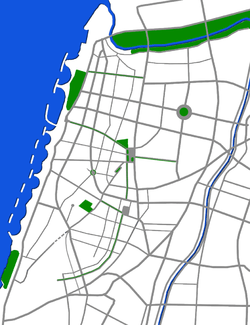
| Tel Aviv, Israel | Nahalat Binyamin Street | 432,900 | This is a pedestrianized street lined by shops and cafes, which hosts a weekly arts fair. |
| Tel Aviv, Israel | Shenkin Street (from Allenby Street to Ahed HaAm) | This is a pedestrianized street lined by shops and cafes, was closed to vehicular traffic in November 2011 and a Pedestrian Mall is under construction. Completion is expect by the Summer of 2012. | |
| Tel Aviv, Israel | Sarona | An old German Templar colony restored into a car-free, well groomed park, with shops, restaurants and kids playgrounds. | |
United Arab Emirates
| Location | Area | Population | Character |
|---|---|---|---|
| Masdar City, Abu Dhabi | New, purpose-built sustainable city | 75,000 | Under construction in 2010, due to open in 2016. Home to the nation's new sustainability institute. |
Nepal
| Location | Area | Population | Character |
|---|---|---|---|
| Bhaktapur, Nepal | Entire town | Around 70,000 | A brick-paved historical culture town and a UNESCO World Heritage site. Formally, motorized traffic is banned, but the law is not enforced. As a result, motorcycles and (to a lesser extent) larger vehicles are seen along the main streets. |
New Zealand
| Location | Area | Population | Character |
|---|---|---|---|
| Tokelau | Pacific island | 1466 permanent residents | Although cars are allowed on the islands, due to its limited development, only 4 cars are present on the whole of the 4 islands.[39] |
Australia
| Location | Area | Population | Character |
|---|---|---|---|
| Rundle Mall, Adelaide | Section of Rundle Street, 320m long, in the heart of Adelaide's CBD. Largest urban pedestrian area in the southern hemisphere. | No private or transit vehicles allowed, only the emergency or construction vehicles. | |
| Rottnest Island, Western Australia | Tourist island | 300 permanent residents | No cars allowed on island, all transport is on foot, bicycle or the regular bus service. |
| Maria Island, Tasmania | Tourist island | 15 permanent residents | No cars allowed on island, all transport is on foot or bicycles. Park rangers are only permanent residents. |
| Shield & Lake Street, Cairns City Centre, Queensland | Shopping area & Transit hub | No private vehicles allowed in Shield Street area: intersects Lake Street (which allows all traffic). Bus lines run through Lake Street, bicycle stands throughout. | |
| Esplanade, Cairns, Queensland | Recreation & Transit hub | No private vehicles allowed, dedicated cycling lanes & pedestrian boulevards, with a public swimming pool and multiple exercise stations. Transit hub for bus & marina. | |
| Green Island, Queensland | Tourist island & National Park | 1 semi-permanent resident (park ranger) | No cars allowed, helicopter access via helipad on southern side of the island, for transit and emergency access. Island contains a resort: majority of transport is on foot (few electric carts are used for emergencies and maintenance work). |
| Elizabeth Street Mall, Hobart, Tasmania | Shopping area. | No cars allowed, all transport is on foot. | |
| Brisbane Street Mall, Launceston, Tasmania | Shopping area. | No cars allowed, all transport is on foot. | |
| Rooke Street Mall, Devonport, Tasmania | Shopping area. | No cars allowed, all transport is on foot. | |
| Lord Howe Island, New South Wales | Tourist island | 350 permanent residents | A small number of resident permits, however most transport is on foot or bicycles. |
| Melbourne city centre (some areas) | Bourke Street Mall and large number of city laneways including Block Arcade, Royal Arcade, Degraves Lane, QV, City Square and Federation Square. Home to growing residential population.[40][41] | 20,000 permanent residents. Thousands of workers and tourists. | No private cars, some exemptions for Swanston Street. Bicycles not allowed on Bourke Street Mall. |
| Civic Square, Canberra ACT | Central shopping area from Civic Bus Interchange, all the way down to Glebe Park, Canberra. Includes Garema Place and Petrie Plaza. Until recently, Civic Bus Interchange was also a Shared Zone, however shared zone signs have now been removed and replaced with standard 20 km/h speed limit signs, thus removing right of way for pedestrians. | No private cars. An area frequented by tourists, students and shoppers. Plenty of bike parking exists. | |
| Queen Street Mall, Brisbane Queensland | Central shopping area, connects with King George Square | No private cars. Underground busway. | |
| Sydney central business district (some areas) | Central shopping area. Pitt Street Mall, Martin Place and tourist precinct Darling Harbour, New South Wales. Much of George Street, Sydney soon to become car-free.[42] | Some ferries and trams. | |
| Dangar Island, New South Wales | Island. | 303 | No private cars allowed, most transport is on foot, bicycle or wheelbarrow. |
| Falls Creek, Victoria (winter only) | Snowsports resort | 252 | Roads in the town area are closed to cars during the snow season, but open to snowmobiles and snowcats. Snowsport riders often use the roads to access pistes. |
See also
References
- "Portale Istituzionale del Comune di Parma - Comune - Dati statistici". www.comune.parma.it. Retrieved 2017-04-10.
- "Urbanistički plan uređenja Zlarina" (PDF) (in Croatian). City of Šibenik. April 2009. Retrieved 2013-06-05.
- "silba.aventin.hr" (in Croatian). Retrieved 2014-05-29.
- Carfree France
- Carfree France
- Carfree France
- Carfree France
- Carfree France
- Carfree France
- Carfree islands
- "Un plan climat met Paris sur la voie de la neutralité carbone".
- Monheim, R. (1997). "The Evolution from Pedestrian Areas to 'Car-free' City Centres in Germany". In Tolley, R. (ed.). The greening of urban transport : planning for walking and cycling in Western cities (2nd ed.). Chichester: Wiley. pp. 253–265.
- "Topography: The Garden City Piesteritz". BR Online (in German). November 26, 2000. Archived from the original on November 6, 2001.
- "THE CARFREE SETTING ON THE SAARLANDSTRASSE". autofreieswohnen (in German). Archived from the original on August 4, 2004.
- "Living without a car in Munich". Wohnen Ohne Auto (in German). Archived from the original on August 18, 2004.
- "The car-free settlement Weißenburg in Münster". Gartensiedlung (in German). October 14, 2011. Archived from the original on May 5, 2012.
- "Statistics on Como population" (PDF).
- Gemeente Groningen, 2008. Statistisch Jaarboek
- http://www.porto.pt/assets/misc/documentos/2020/Mobilidade/Zonas%20pedonais%20tempor%C3%A1rias.pdf
- Kazandžijsko sokače Archived 2011-03-20 at the Wayback Machine
- Barcelona city council webpage - data from 2007
- "Members to vote on enlarged Chester pedestrian zone". Place North West. 12 February 2014. Retrieved 7 May 2016.
- Mapa Turístico - Ilha Grande Archived 2009-01-23 at the Wayback Machine
- Bogotá's green revolution Archived 2007-03-21 at the Wayback Machine
- The Politics of Happiness Archived 2006-11-30 at the Wayback Machine
- "Una calle más para peatones del Centro Histórico - Animal Político". www.animalpolitico.com (in Spanish). Retrieved 2018-01-17.
- What happened when Oslo decided to make its downtown basically car-free?
- What happens when a city bans cars from its streets?
- Oslo Is (Almost) Car-Free — And Likes It That Way
- "Canal Walk". Visit Indy. Retrieved 2014-08-20.
- McManus, Melanie Radzicki. "No cars allowed: Michigan's Mackinac is an island of bicycles". Star Tribune. Retrieved 5 August 2020.
- The book of cities by Philip Dodd
- carfree.com by J.H. Crawford
- carfree.com by J.H. Crawford
- "Phu Quoc Island: Trouble in Paradise". The Ecologist. Retrieved 2018-01-17.
- Planet, Lonely. "Phu Quoc Island travel - Lonely Planet". Lonely Planet. Retrieved 2018-01-17.
- "Fazilka: Come Without Your Car – Carbusters". carbusters.org. Retrieved 2018-01-17.
- Elephanta island on Lonely Planet
- "Tokelau looks to independence". The Sunday Star-Times. October 21, 2007. Retrieved October 15, 2011.
- "Melbourne: A Pedestrian Paradise". Streetfilms.
- The Age, January 27, 2010
- "George Street - City of Sydney". www.cityofsydney.nsw.gov.au. Retrieved 2018-01-17.