List of Alberta provincial highways
The Canadian province of Alberta has provincial highway network of nearly 31,000 kilometres (19,000 mi) as of 2009, of which 24,851 kilometres (15,442 mi) were paved.[1]
| Alberta provincial highway system | |
|---|---|
   Standard highway markers for Alberta | |
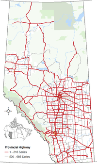
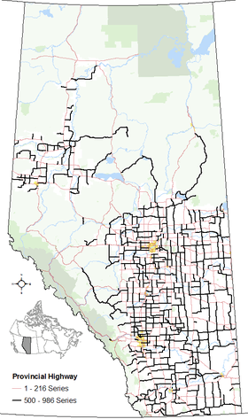
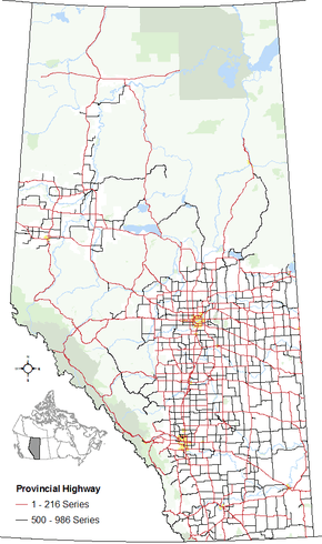 Alberta's provincial highway system as of 2016 | |
| Highway names | |
| Provincial Highways | Alberta Highway XX (Hwy XX) |
| System links | |
| Provincial highways in Alberta | |
All of Alberta's provincial highways are maintained by Alberta Transportation (AT), a department of the Government of Alberta. The network includes two distinct series of numbered highways:
- The 1–216 series (formerly known as primary highways), making up Alberta's core highway network—typically with the highest traffic volume and mostly paved
- The 500–986 series, providing more local access, with a higher proportion of gravel surfaces
History
In 1926, Alberta discontinued its system of marking highways with different colours in favour of a numbering system.[2] By 1928, the year a gravel road stretched from Edmonton to the United States border, Alberta's provincial highway network comprised 2,310 km (1,440 mi).[2]
Prior to 1973, the expanding highway system comprised one-digit and two-digit highways, with some numbers having letter suffixes (e.g., Highway 1X, Highway 26A).[3] In 1973, a second highway system emerged, using three digits starting in the 500s and referred to as secondary roads, while the existing system continued to be referred to as provincial highways.[4] In 1974, provincial highways became known as primary highways;[5] and in 1990, secondary roads became known as secondary highways.[6]
Secondary highways were abolished in 2000, with most becoming primary highways.[7] The expanded primary highway system was divided into two subsets: former primary highways, which became the 1–216 series;[8] and former secondary highways, which became the 500–986 series.[9] In 2010, all highways became known as provincial highways, while maintaining the two numbered series.[10][11] Despite this, the series are still often referred to as primary and secondary highways, respectively.
1 - 216 series

Alberta's 1 to 216 series of provincial highways are Alberta's main highways. They are numbered from 1 to 100, with the exception of the ring roads around Calgary and Edmonton, which are numbered 201 and 216 respectively. The numbers applied to these highways are derived from compounding the assigned numbers of the core north-south and east-west highways that intersect with the rings roads. In Calgary, Highway 201 is derived from the north-south Highway 2 and the east-west Highway 1. In Edmonton, Highway 216 is derived from the same north-south Highway 2 and the east-west Highway 16.
Within this series, all or portions of Highways 1, 2, 3, 4, 9, 15, 16, 28, 28A, 35, 43, 49, 63, 201 and 216 are designated core routes of Canada's National Highway System (NHS).[12] Highway 28 from Highway 63 to Cold Lake is designated a NHS feeder route and Highway 58 between Rainbow Lake and Highway 88 is designated a NHS northern/remote route.[12]
Highways 1, 2, 3, 4, 16, and 43 are considered Alberta's most important interprovincial and international highways and are divided highways (expressways) or freeways for much or all of their length. Speed limits are generally 110 km/h (70 mph) divided highways/freeways and 100 km/h (65 mph) on others. Segments of Highway 1 and Highway 16 through the national parks within Alberta's Rockies that can be 90 km/h (55 mph) or 70 km/h (45 mph).
The Highway 15/28A/28/63 corridor between Edmonton and Fort McMurray is considered one of Alberta's most important intraprovincial highways. It is vital to the oilsands operation.
Although only Highways 1, 2, 3, 4, 11, 15, 16, 43, 63, 100, 201, and 216 are twinned (expressways) for most of their length, the vast majority of Alberta's 1 to 216 series of highways are two-laned and paved. Only four highways within the series have segments that remained gravelled. These include segments of Highways 40, 58, and 68 and a short segment near the northern terminus of Highway 63.[13]
Highways 1, 16, 201, and 216 are Trans-Canada Highway routes and are signed with TCH shields, not standard provincial shields.
| Number | Length (km) | Length (mi) | Southern or western terminus | Northern or eastern terminus | Local names | Formed | Removed | Notes |
|---|---|---|---|---|---|---|---|---|
| 534 | 332 | B.C. border at Kicking Horse Pass (continues as BC 1) | Sask. border east of Walsh (continues as SK 1) |
Trans-Canada Highway | c. 1941 | current | Signed with Trans-Canada Highway shield; passes through Banff, Calgary, and Medicine Hat. | |
| 1,370 | 851 | U.S. (Montana) border at Carway | B.C. border west of Demmitt | 1926 | c. 1941 | Replaced by Hwy 2; passes through Calgary, Red Deer, Edmonton, Peace River and Grande Prairie.[14] | ||
| 60 | 37 | Bassano | Brooks | c. 1941[15] | c. 1955[16] | Replaced by Hwy 36 between Brooks and Duchess; became Hwy 550 and Hwy 873 in 1973. | ||
| 51 | 32 | Hwy 1 at Lake Louise | Hwy 1 west of Banff | Bow Valley Parkway | — | — | Former section of Hwy 1. | |
| 89 | 55 | Hwy 1 in Canmore | Hwy 1 in Calgary | Bow Valley Trail | c. 1957 | current | Former section of Hwy 1. | |
| 6 | 4 | B.C. border at Kicking Horse Pass (continued as BC 1A) | Hwy 1 at Lake Louise | Kicking Horse Trail | 1962 | c. 1990s | Route closed to automobile traffic. | |
| 228 | 142 | Hwy 1 west of Lake Louise | Hwy 16 in Jasper | Icefields Parkway | 1940 | 1959 | Replaced by Hwy 93.[17] | |
| 11 | 7 | Hwy 1 (16 Avenue NW) / Crowchild Trail in Calgary | Hwy 2 (Deerfoot Trail) / 17 Avenue SE in Calgary | • 14 Street W • 6 Avenue S • 9 Avenue S |
1949 | c. 1980 | Former section of Hwy 1 through downtown Calgary; Hwy 1A was split into two sections when decommissioned. | |
| 14 | 9 | Hwy 2 (Deerfoot Trail) in Calgary | Hwy 1 in Chestermere | 17 Avenue SE | 1949 | 2013 | Former section of Hwy 1 through east Calgary. | |
| 11 | 7 | B.C. border at Vermilion Pass (continued as BC 1B) | Hwy 1 at Castle Junction | Banff–Windermere Highway | 1941 | 1959 | Replaced by Hwy 93.[17] | |
| 5 | 3 | Hwy 1A east of Exshaw | Hwy 1 south of Seebe | c. 1961 | current | |||
| 1,273 | 791 | U.S. (Montana) border at Carway (continues as US 89) | Hwy 43 north of Grande Prairie | • Queen Elizabeth II Highway (Calgary – Edmonton) • Northern Woods and Water Route (Athabasca – Donnelly) |
c. 1941 | current | Passes through Calgary, Red Deer, Edmonton, and Peace River. | |
| 534 | 332 | B.C. border at Kicking Horse Pass | Sask. border east of Walsh | 1926 | c. 1941 | Replaced by Hwy 1; passed through Banff, Calgary, and Medicine Hat.[14] | ||
| 97 | 60 | B.C. border west of Demmitt (continued as BC 2) | Hwy 34 (now Hwy 43) north of Grande Prairie | c. 1941 | 1998[18] | Section replaced by Hwy 43. | ||
| 46 | 29 | Hwy 23 in High River | Hwy 201 / Hwy 22X in Calgary | c. 1960 | current | Former section of Hwy 2. | ||
| 229 | 142 | Hwy 2 / Hwy 72 east of Crossfield | Hwy 2 in Leduc | 1954 | current | Former section of Hwy 2; passes through Red Deer | ||
| 15 | 9 | Hwy 2 south of Hondo | Smith | — | — | Former section of Hwy 2. | ||
| 27 | 17 | Hwy 2 west of High Prairie | Hwy 49 south of Guy | — | — | Former section of Hwy 2. | ||
| 11 | 7 | Hwy 2 west of Peace River | Hwy 2 in Grimshaw | — | — | Former section of Hwy 2. | ||
| 20 | 12 | Hwy 2 north of Nanton | Hwy 23 in High River | — | 1996[19][20] | Former section of Hwy 2. | ||
| 11 | 7 | Hwy 1 in Calgary | Hwy 2 north of Calgary | Barlow Trail | — | c. 1980s | Former section of Hwy 2. | |
| 8 | 5 | Hwy 2 (109 Street) in Edmonton | Hwy 2 (St. Albert Trail / 118 Avenue) in Edmonton | • Whyte Avenue • University Avenue • Saskatchewan Drive • Groat Road |
1955 | 1970 | Downtown Edmonton bypass via Groat Bridge. | |
| 324 | 201 | B.C. border at Crowsnest Pass (continues as BC 3) | Hwy 1 / Hwy 41A in Medicine Hat | Crowsnest Highway | 1926 | current | Signed with Crowsnest Highway shield; passes through Lethbridge. | |
| 4 | 2 | Hwy 3 at Lundbreck Falls | Hwy 3 at Lundbreck | 1967 | current | Former section of Hwy 3; unsigned. | ||
| 8 | 5 | Hwy 3 west of Monarch | Hwy 3 / Hwy 23 east of Monarch | 1996 | current | Former section of Hwy 3. | ||
| 0.65 | 0.40 | Hwy 3 east of Coalhurst | Lethbridge city limits | Westside Drive | 1967 | current | Former section of Hwy 3; unsigned. | |
| 7 | 4 | Business route through Barnwell | 1998 | current | Former section of Hwy 3; unsigned. | |||
| 6 | 4 | Hwy 3 east of Coalhurst | Hwy 3 in Lethbridge | • Westside Drive • Bridge Drive |
1967 | c. 1980s | Former section of Hwy 3; all but a 650 m section, was decommissioned when the area was annexed by the City of Lethbridge. | |
| 103 | 64 | U.S. (Montana) border at Coutts (continues as I-15) | Hwy 3 in Lethbridge | 1926 | current | |||
| 129 | 80 | Waterton Park | Hwy 3 in Lethbridge | Cowboy Trail (Waterton Lakes N.P – Cardston) |
1926 | current | ||
| 74 | 46 | U.S. (Montana) border at Chief Mountain (continues as MT 17) | Hwy 3 at Pincher Station | Cowboy Trail (Waterton Lakes N.P – Pincher Station) |
1926 | current | ||
| 26 | 16 | Hwy 22 in Black Diamond | Hwy 2 / Hwy 547 at Aldersyde | — | — | |||
| 17 | 11 | Black Diamond | Longview | — | — | Section replaced by Hwy 22. | ||
| 31 | 19 | Hwy 22 north of Redwood Meadows | Hwy 2 in Calgary | Glenmore Trail | — | — | 9 km (5.6 mi) section in Calgary between Sarcee Trail and Deerfoot Trail (Hwy 2) is unsigned. | |
| 11 | 7 | Hwy 1A (14 Street NW) in Calgary | Bowness Park in Bowness | • Kensington Road • Parkdale Boulevard • 3 Avenue NW • Bowness Road • 85 Street NW |
— | 1964 | Serviced the former towns of Montgomery and Bowness. Decommissioned after the towns were annexed by the City of Calgary. | |
| 324 | 201 | Hwy 1 / Hwy 797 north of Langdon | Sask. border at Alsask, SK (continues as SK 7) |
— | — | |||
| 23 | 14 | Hwy 9 / Hwy 56 in Drumheller | Hwy 564 / Hwy 569 east of East Coulee | Hoo Doo Trail | — | — | Entire route is in the Town of Drumheller. | |
| 6 | 4 | Hwy 9 / Hwy 56 at Rosedale | Wayne | — | — | Entire route is in the Town of Drumheller. | ||
| 318 | 198 | Hwy 93 at Saskatchewan River Crossing | Hwy 12 east of Nevis | David Thompson Highway | — | — | Passes through Red Deer. | |
| 12 | 7 | Hwy 11 / Hwy 756 west of Rocky Mountain House | Hwy 11 / Hwy 22 / Hwy 598 in Rocky Mountain House | — | — | Former section of Hwy 11. | ||
| 17 | 11 | Hwy 20 in Sylvan Lake | Hwy 2A in Red Deer | c. 1987 | current | Former section of Hwy 11. | ||
| 13 | 8 | Hwy 11 at Benalto | Hwy 20 in Sylvan Lake | c. 1987 | c. 2008 | Former section of Hwy 11. | ||
| 28 | 17 | Hwy 11 at Benalto | Hwy 2 in Red Deer | c. 1985 | c. 1987 | Designation of Sylvan Lake bypass during construction; replaced by Hwy 11. | ||
| 364 | 226 | Hwy 22 north of Rocky Mountain House | Sask. border at Compeer (continues as SK 51) |
— | — | |||
| 9 | 6 | Hwy 12 at Bentley | Hwy 12 at Gull Lake | 2017 | current | Former section of Hwy 12. | ||
| 90 | 56 | Hwy 20 / Hwy 51 at Bentley | Hwy 39 at Alsike | — | c. 1980s | Section replaced by Hwy 20. | ||
| 366 | 227 | Alder Flats | Sask. border east of Hayter (continues as SK 14) |
— | — | |||
| 7 | 4 | Hwy 13 at Westerose | Hwy 13 east of Ma-Me-O Beach | c. 2000s | current | Former Hwy 13 through Ma-Me-O Beach. | ||
| 8 | 5 | Camrose bypass | Camrose Drive | 1988 | current | Maintained by the City of Camrose. | ||
| 5 | 3 | Hwy 2A / Hwy 13 in Wetaskiwin | Hwy 13 / Hwy 814 north of Wetaskiwin | — | — | Alternate route through Wetaskiwin. | ||
| 257 | 160 | Hwy 2 in Edmonton | Sask. border west of Marsden, SK (continues as SK 40) |
Poundmaker Trail | — | — | ||
| 3 | 2 | Downtown Edmonton | Hwy 14 (Whyte Avenue) in Edmonton | • Connors Road • 83 Street |
c. 1960 | c. 1970 | ||
| 6 | 4 | Edmonton | Hwy 14 (Sherwood Park Freeway) near Sherwood Park | 79 Avenue | 1968 | c. 1970s | Former section of Hwy 14. | |
| 3 | 2 | Hwy 14 (Sherwood Park Freeway) between Edmonton and Sherwood Park | Hwy 16A (Baseline Road) between Edmonton and Sherwood Park | c. 1950s | 1999[21] | Replaced by Hwy 216. | ||
| 3 | 2 | Baseline Road between Edmonton and Sherwood Park | Hwy 16 between Edmonton and Sherwood Park | 1996[22] | 1999[21] | Replaced section of Hwy 16A; replaced by Hwy 216. | ||
| 93 | 58 | Hwy 16 in Edmonton | Hwy 16 / Hwy 854 south of Mundare | 1940 | current | Former section of Hwy 16. | ||
| 80 | 50 | Hwy 16 in downtown Edmonton | Hwy 16 south of Mundare | c. 1930s | 1940 | Passed through Elk Island National Park; replaced by Hwy 16. | ||
| 634 | 394 | B.C. border at Yellowhead Pass (continues as BC 16) | Sask. border in Lloydminster (continues as SK 16) |
• Yellowhead Highway • Trans-Canada Highway |
— | — | Signed with Trans-Canada Highway shield; cosigned with Yellowhead Highway shield; passes through Jasper, Edmonton, and Lloydminster. | |
| 98 | 61 | Hwy 15 in Edmonton | Hwy 15 south of Mundare | c. 1930s | 1940 | Passed through Fort Saskatchewan; section replaced by Hwy 15. | ||
| 14 | 9 | Hwy 16 west of Evansburg | Hwy 16 / Hwy 22 at Entwistle | — | — | Former section of Hwy 16. | ||
| 33 | 21 | Hwy 16 west of Stony Plain | Hwy 216 in Edmonton | Parkland Highway | 1997[23] | current | Former section of Hwy 16. | |
| 9 | 6 | Business route through Vegreville | 1986 | current | Former section of Hwy 16. | |||
| 16 | 10 | Hwy 16 in Edmonton | Edmonton eastern city limits | c. 1950s | c. 1980s | Former section of Hwy 16 through downtown Edmonton. | ||
| 7 | 4 | Edmonton city limits | Hwy 16 east of Edmonton | c. 1950s | 1996[22] | Portion replaced by Hwy 14X (now Hwy 216). | ||
| 36 | 22 | Hwy 16 west of Stony Plain | Hwy 2 / Hwy 16 in Edmonton | c. 1970s | 1997[23] | Replaced by Hwy 16. | ||
| 134 | 83 | Sask. border at Dillberry Lake Provincial Park | Onion Lake | c. 1940s | current | Runs along the Alberta-Saskatchewan border; cosigned with SK 17. | ||
| 14 | 9 | Hwy 16 at Manly Corner | Onoway | c. 1930s | c. 1940s[24][25] | Replaced by Hwy 43. | ||
| 161 | 100 | Hwy 43 at Green Court | Hwy 2 / Hwy 656 east of Thorhild | — | — | |||
| 97 | 60 | Hwy 933 (now Hwy 33) at Barrhead | Swan Hills | — | c. 1977 | Section replaced by Hwy 33. | ||
| 12 | 7 | Hwy 60 at Devon | Hwy 2 / Hwy 625 at Nisku | c. 1982 | current | |||
| 70 | 43 | Hwy 12 (now Hwy 20) at Winfield | Hwy 2 (now Hwy 2A) in Wetaskiwin | — | c. 1969 | Replaced by Hwy 13. | ||
| 110 | 68 | Hwy 11 in Sylvan Lake | Hwy 39 at Alsike | — | — | |||
| 3 | 2 | Hwy 20 east of Rimbey | Hwy 20 / Hwy 53 north of Rimbey | — | — | Former Hwy 20. | ||
| 328 | 204 | Hwy 1 east of Strathmore | Hwy 15 in Fort Saskatchewan | — | — | |||
| 33 | 21 | Hwy 9 at Beiseker | Hwy 21 east of Carbon | 1958 | c. 1962 | Former section of Hwy 21; replaced by Hwy 26 (now Hwy 575 and Hwy 806). | ||
| 5 | 3 | Hwy 21 southeast of Nevis | Hwy 12 east of Nevis | — | c. 1991 | Replaced by Hwy 11. | ||
| 574 | 357 | Hwy 3 west of Lundbreck | Hwy 18 north of Mayerthorpe | Cowboy Trail | — | — | ||
| 17 | 11 | Hwy 553 (now Hwy 22) near Priddis | Hwy 2 (now Hwy 2A) south of Calgary | — | c. 1976 | Replaced by Hwy 22X. | ||
| 54 | 34 | Hwy 22 near Priddis | Hwy 24 / Hwy 901 south of Cheadle | c. 1976 | current | Former Hwy 22 west of Calgary. | ||
| 138 | 86 | Hwy 3 near Monarch | Hwy 2A in High River | — | — | |||
| 69 | 43 | Hwy 23 north of Vulcan | Hwy 1 north of Cheadle | — | — | |||
| 72 | 45 | Hwy 3 in Lethbridge | Hwy 526 west of Enchant | — | — | |||
| 82 | 51 | Hwy 13 in Camrose | Hwy 14 west of Kinsella | c. 1970s | current | |||
| 52 | 32 | Hwy 9 south of Carbon | Hwy 9 at Beiseker | — | 1970 | Replaced by portions of Hwy 575, Hwy 806, and Hwy 836. | ||
| 150 | 93 | Hwy 22 / Hwy 584 in Sundre | Hwy 9 / Hwy 56 east of Morrin | — | — | |||
| 293 | 182 | Hwy 16 in Edmonton | Cold Lake | — | — | |||
| 49 | 30 | Hwy 36 at St. Brides | Hwy 41 east of St. Paul | — | 2006 | Section replaced by Hwy 29. | ||
| 18 | 11 | Hwy 15 in Edmonton | Hwy 28 at Gibbons | c. 1980s | current | Former section of Hwy 37. | ||
| 3 | 2 | Hwy 28 north of Edmonton | CFB Edmonton | — | — | Access road to CFB Edmonton. | ||
| 46 | 29 | Hwy 28 / Hwy 36 at Ashmont | Hwy 28 / Hwy 41 at Hoselaw | — | 2006 | Replaced by Hwy 28. | ||
| 13 | 8 | Hwy 28 near Beaver Crossing | Sask. border near Cherry Grove (continued as SK 55) |
— | c. 1977 | Replaced by Hwy 55. | ||
| 152 | 94 | Hwy 15 west of Lamont | Hwy 41 east of St. Paul | 2006 | current | |||
| 6 | 4 | Spring Lake (formerly Edmonton Beach) | Hwy 16 (now Hwy 16A) west of Stony Plain | • Range Road 15 • Township Road 530 |
— | c. 1985 | ||
| 3.5 | 2.2 | Kapasiwin | Hwy 16 east of Wabamun | • Range Road 42 • Range Road 35 |
— | c. 1994 | ||
| 4 | 2 | Hwy 16 east of Gainford | Hwy 759 at Seba Beach | — | — | |||
| 147 | 91 | Hwy 16 west of Carrot Creek | Hwy 33 at Swan Hills | — | — | |||
| 219 | 136 | Hwy 43 east of Gunn | Hwy 2 east of Kinuso | Grizzly Trail | — | — | ||
| 10 | 6 | Hwy 43 south of Onoway | Alberta Beach | — | c. 1985 | Section replaced by Hwy 633. | ||
| 152 | 94 | Hwy 2 north of Grande Prairie | Hwy 2 (now Hwy 49) north of Guy | 1939 | 1998[18] | 47 km (29 mi) section between Valleyview and Guy replaced by Hwy 43 (now Hwy 49) in the early 1990s; remainder replaced by Hwy 43. | ||
| 47 | 29 | Hwy 34 (now Hwy 49) north of Valleyview | Hwy 2 (now Hwy 2A) west of High Prairie | 1959 | 1966 | Former Hwy 34. | ||
| 465 | 289 | Hwy 2 north of Grimshaw | N.W.T. border north of Indian Cabins (continues as NT 1) |
Mackenzie Highway | — | — | Signed with Mackenzie Highway shield. | |
| 681 | 423 | Hwy 4 at Warner | Hwy 55 at Lac La Biche | Veterans Memorial Highway | — | — | ||
| 67 | 42 | Hwy 43 west of Onoway | Hwy 15 west of Fort Saskatchewan | — | — | |||
| 25 | 16 | Hwy 28 at Redwater | Hwy 45 north of Bruderheim | — | — | |||
| 3.2 | 2.0 | Stony Plain Road (former Hwy 16A) | 79 Avenue (now Whitemud Drive) | 156 Street | — | c. 1962 | Serviced the former town of Jasper Place; decommissioned when the town was annexed by the city of Edmonton. | |
| 91 | 57 | Hwy 22 east of Drayton Valley | Hwy 2 in Leduc | — | — | |||
| 3.8 | 2.4 | Hwy 3 at Coleman | Forestry Trunk Road at the Municipality of Crowsnest Pass boundary | Forestry Trunk Road | — | — | ||
| 104 | 65 | Hwy 541 / Forestry Trunk Road west of Longview | Hwy 1 south of Seebe | Kananaskis Trail | — | — | Annually closed between Peter Lougheed Provincial Park and Hwy 541 from December 1 – June 14.[26] | |
| 46 | 29 | Hwy 1A near Ghost Lake | Hwy 579 / Forestry Trunk Road west of Water Valley | Forestry Trunk Road | — | — | ||
| 434 | 270 | Hwy 734 at Lovett River | Hwy 43 in Grande Prairie | Bighorn Highway | — | — | ||
| 24 | 15 | U.S. (Montana) border at Whiskey Gap | Hwy 2 south Cardston | — | 1971 | Border crossing closed; majority of route replaced by Hwy 501 | ||
| 688 | 428 | U.S. (Montana) border at Wild Horse (continues as S-232) | Hwy 55 at La Corey | Buffalo Trail | — | — | ||
| 15 | 9 | Hwy 1 / Hwy 3 at Medicine Hat | Hwy 41 east of Medicine Hat | — | — | Former Hwy 41. | ||
| 44 | 27 | Hwy 2A / Hwy 592 at Penhold | Hwy 21 west of Lousana | — | — | |||
| 497 | 309 | B.C. border near Demmitt (continues as BC 2) | Hwy 16 at Manly Corner | c. 1940s | current | Passes through Grande Prairie. | ||
| 77 | 48 | Hwy 2 / Hwy 49) west of Donnelly | Hwy 34 (now Hwy 43) in Valleyview | c. 1990 | 1998[18] | Section replaced by Hwy 49. | ||
| 16 | 10 | Range Road 63 (116 Street) north of Grande Prairie Hwy 43 west of Grande Prairie | Hwy 2 / Hwy 43 at Clairmont | 2010 | current | 4 km (2 mi) section between 116 Street and Hwy 2 / Hwy 43 opened 2010; 12 km (7 mi) extension scheduled to open Fall 2018.[29] | ||
| 171 | 106 | Hwy 16 west of Acheson | Hwy 2 near Hondo | — | — | |||
| 231 | 144 | Hwy 15 south of Bruderheim | Sask. border near Alcurve (continues as SK 3) |
— | — | |||
| 152 | 94 | Hwy 28 at Radway | Hwy 36 at Lac La Biche | — | c. 1978 | Replaced by portions of Hwy 55 and Hwy 63.[30][31] | ||
| 60 | 37 | Hwy 40 at Coalspur | Hwy 16 west of Edson | — | — | |||
| 114 | 71 | U.S. (Montana) border at Wild Horse (continued as S-232) | Hwy 1 west of Irvine | — | 1979 | Replaced by Hwy 41.[32][33] | ||
| 266 | 165 | B.C. border west of Bay Tree (continues as BC 49) | Hwy 43 in Valleyview | Northern Woods and Water Route | — | — | ||
| 14 | 9 | Hwy 12 at Tees | Hwy 21 at Mirror | — | — | |||
| 36 | 22 | Hwy 761 north of Leslieville | Hwy 12 / Hwy 20 at Bentley | c. 1950s | c. 1985 | Replaced by Hwy 12.[34][35] | ||
| 24 | 15 | Hwy 5 at Welling Station | Hwy 4 at Craddock | — | — | |||
| 222 | 138 | Hwy 22 west of Rimbey | Hwy 36 / Hwy 608 east of Forestburg | — | — | |||
| 69 | 43 | Hwy 22 / Hwy 608 west of Caroline | Hwy 2 at Innisfail | — | — | |||
| 263 | 163 | Hwy 2 in Athabasca | Sask. border east of Cherry Grove (continues as SK 55) |
Northern Woods and Water Route | c. 1976 | current | ||
| 15 | 9 | Hwy 16 east of Edmonton | Hwy 15 in Fort Saskatchewan | — | c. 1976 | Replaced by Hwy 21. | ||
| 246 | 153 | Hwy 1 northwest of Bassano | Hwy 13 / Hwy 834 east of Camrose | — | — | |||
| 82 | 51 | Hwy 39 at Alsike | Hwy 16 at Entwistle | — | 1979 | Replaced by Hwy 22 and Hwy 39.[36][37] | ||
| 325 | 202 | Rainbow Lake | Garden River | — | — | |||
| 22 | 14 | Fort Vermilion | Hwy 58 north of Fort Vermilion | c. 1970 | c. 1973 | Replaced by Hwy 67 (now Hwy 88). | ||
| 62 | 39 | Hwy 43 northwest of Hythe | Hwy 2 north of Sexsmith | — | — | |||
| 35 | 22 | Hwy 39 east of Calmar | Hwy 16 at Acheson | Devonian Way | — | — | ||
| 147 | 91 | Hwy 4 / Hwy 846 at Stirling | Hwy 889 at Manyberries | Red Coat Trail | 1959 | current | ||
| 52 | 32 | U.S. (Montana) border south of Del Bonita (continues as S-213) | Hwy 5 at Magrath | — | — | |||
| 434 | 270 | Hwy 28 east of Radway | Winter road north of Fort MacKay | 1962 | current | Passes through Fort McMurray. | ||
| 126 | 78 | B.C. border near Bear Canyon (continues as Cecil Lake Road) | Hwy 2 southwest of Fairview | — | — | |||
| 6.6 | 4.1 | Hwy 64 west of Fairview | Hwy 2 in Fairview | — | — | |||
| 28 | 17 | Don Getty Wildland Provincial Park | Hwy 22 south of Bragg Creek | — | — | |||
| 428 | 266 | Hwy 2 at Slave Lake | Hwy 58 north of Fort Vermilion | c. 1973 | 1988 | Replaced by Hwy 88. | ||
| 37 | 23 | Hwy 40 at Bow Valley Provincial Park | Hwy 1 east of Morley | Sibbald Creek Trail | — | — | ||
| 14 | 9 | Hwy 63 in Fort McMurray | Saprae Creek | Airport Road | c. 1975 | c. 2014 | Reverted to R.M. of Wood Buffalo.[38] | |
| 33 | 21 | Hwy 2 / Hwy 2A south of Crossfield | Hwy 9 / Hwy 806 at Beiseker | c. 1980s | current | Former Hwy 572. | ||
| 428 | 266 | Hwy 2 at Slave Lake | Hwy 58 north of Fort Vermilion | Bicentennial Highway | 1988 | current | Signed with Bicentennial Highway shield; former Hwy 67 | |
| 24 | 15 | Hwy 28 west of Ardmore | Township Road 643 west of Cold Lake | c. 1981 | c. 1985 | Former Hwy 992;[39][40] replaced by Hwy 892.[41][42] | ||
| 265 | 165 | B.C. border at Vermilion Pass (continues as BC 93) | Hwy 16 at Jasper | • Banff–Windermere Highway • Icefields Parkway |
1959 | current | ||
| 24 | 15 | Hwy 93 at Athabasca Falls | Hwy 93 east of Marmot Basin | — | — | |||
| 1.7 | 1.1 | Hwy 93 south Jasper | Hwy 16 at Jasper | — | — | |||
| SPF | 7.1 | 4.4 | Edmonton city limits | Hwy 216 in Sherwood Park | Sherwood Park Freeway | 1999 | current | Unsigned Hwy 100; former Hwy 14. |
| 69 | 43 | Calgary ring road | • Stoney Trail • Tsuut’ina Trail |
c. 1990s | current | No western leg; southwest segment opening scheduled in 2021. | ||
| 77 | 48 | Edmonton ring road | Anthony Henday Drive | 1992 | current | |||
| ||||||||
X series
The roads in the X series are typically highways that are planned realignments or spurs of existing highways. The numbers applied to each highway in the X series are derived from the highway that is planned for realignment or spurred from (e.g. Highway 16X will be a realignment of Highway 16, and Highway 10X is spur from Highway 10).
| Number | Length (km) | Length (mi) | Southern or western terminus | Northern or eastern terminus | Local names | Formed | Removed | Notes |
|---|---|---|---|---|---|---|---|---|
| 5 | 3 | Hwy 1A east of Exshaw | Hwy 1 south of Seebe | c. 1961 | current | |||
| — | — | Strathmore bypass | proposed | — | ROW located south of Strathmore.[13] | |||
| — | — | Medicine Hat bypass | proposed | — | ROW located south of Medicine Hat.[13] | |||
| — | — | Hwy 2 / Hwy 3 west of Fort Macleod | Hwy 2 / Hwy 3 east of Fort Macleod | proposed | — | Stage 1 of Fort Macleod bypass;[43] ROW located south of Fort Macleod.[13] | ||
| — | — | Claresholm bypass | proposed | — | ROW located east of Claresholm.[13] | |||
| — | — | Nanton bypass | proposed | — | ROW located east of Nanton.[13] | |||
| 10 | 6 | Hwy 2 east of De Winton | Hwy 2 / Hwy 22X in Calgary | Deerfoot Trail | — | 2003 | Temporary designation during construction; replaced by Hwy 2 when completed.[44] | |
| — | — | Crowsnest Pass bypass | proposed | — | ROW located south of Crowsnest Pass.[13] | |||
| — | — | Pincher Creek realignment | proposed | — | ROW located south of Hwy 3 to allow for a proposed interchange at Hwy 6.[13][45] | |||
| — | — | Hwy 3 west of Fort Macleod | Hwy 2X west of Fort Macleod | proposed | — | Stage 2 of Fort Macleod bypass;[43] ROW located south of Fort Macleod.[13] | ||
| — | — | Hwy 3 west of Coalhurst | Hwy 3 west of Chin | proposed | — | Lethbridge bypass; ROW located north of Lethbridge.[13] | ||
| — | — | Hwy 4 southeast of Lethbridge | Hwy 3X east of Lethbridge | proposed | — | Lethbridge bypass; ROW located east of Lethbridge.[13] | ||
| — | — | Pincher Creek bypass | proposed | — | ROW located east of Pincher Creek.[13][45] | |||
| 6 | 4 | Hwy 9 / Hwy 56 at Rosedale | Wayne | — | — | |||
| 28 | 17 | Hwy 11 at Benalto | Hwy 2 in Red Deer | c. 1985 | c. 1987 | Designation of Sylvan Lake bypass during construction; replaced by Hwy 11. | ||
| — | — | Hwy 11 in Red Deer | Hwy 11 east of Red Deer | proposed | — | Proposed Hwy 11 realignment (67 Street extension). | ||
| 3 | 2 | Hwy 14 (Sherwood Park Freeway) between Edmonton and Sherwood Park | Hwy 16A (Baseline Road) between Edmonton and Sherwood Park | c. 1950s | 1999[21] | Replaced by Hwy 216. | ||
| 3 | 2 | Baseline Road between Edmonton and Sherwood Park | Hwy 16 between Edmonton and Sherwood Park | 1996[22] | 1999[21] | Replaced section of Hwy 16A; replaced by Hwy 216. | ||
| 36 | 22 | Hwy 16 west of Stony Plain | Hwy 2 / Hwy 16 in Edmonton | c. 1970s | 1997[23] | Replaced by Hwy 16. | ||
| — | — | Hinton bypass | proposed | — | ROW located south of Hinton. | |||
| — | — | Edson bypass | proposed | — | ROW located south of Edson. | |||
| — | — | Hwy 16 east of Blackfoot | Sask. border / Hwy 17 south of Lloydminster | proposed | — | Proposed Lloydminster bypass; ROW located south of Lloydminster. | ||
| 54 | 34 | Hwy 22 near Priddis | Hwy 24 / Hwy 901 south of Cheadle | c. 1976 | current | Former Hwy 22 west of Calgary. | ||
| 13 | 8 | Hwy 28 near Beaver Crossing | Sask. border near Cherry Grove (continued as SK 55) |
— | c. 1977 | Replaced by Hwy 55. | ||
| — | — | Hwy 40 south of Grande Prairie | Hwy 43 west of Grande Prairie | proposed | — | Proposed SW Grande Prairie bypass. | ||
| 16 | 10 | Range Road 63 (116 Street) north of Grande Prairie Hwy 43 west of Grande Prairie | Hwy 2 / Hwy 43 at Clairmont | 2010 | current | 4 km (2 mi) section between 116 Street and Hwy 2 / Hwy 43 opened 2010; 12 km (7 mi) extension scheduled to open Fall 2018.[29] | ||
| — | — | Whitecourt bypass | proposed | — | ROW located south of Whitecourt. | |||
| ||||||||
500 - 986 series
| Contents
500 · 520 · 540 · 560 · 580 |
|---|
Alberta's 500 - 986 series of provincial highways are generally considered local or rural highways. The 500 - 986 series of provincial highways is divided into three sub-series:
- The 500/600 highways are west-east roads where the numbering increases northward from the Montana border to the Northwest Territories border.
- The 700/800 highways are south-north roads where numbering increases eastward from the British Columbia border to the Saskatchewan border.
- The 900 highways are newer or planned roads that have been established for future consideration as or as potential extensions or realignments of highways within the 1 - 216 series.
Some of these highways are paved, while others are entirely or partially gravel. Rural speed limits range from 80 km/h (50 mph) to 100 km/h (62 mph).
 500 subseries
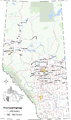 600 subseries
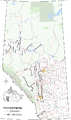 700 subseries
 800 subseries
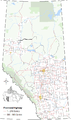 900 subseries
500
| Number | Length (km) | Length (mi) | Southern or western terminus | Northern or eastern terminus | Local name(s) | Opened | Removed | Notes |
|---|---|---|---|---|---|---|---|---|
| 19 | 12 | Hwy 4 in Coutts | Range Road 135 | — |
Current | |||
| 43 | 27 | Hwy 501 north of Writing-on-Stone Provincial Park | Hwy 880 at Aden | — |
Current | |||
| 300 | 186 | Hwy 5 east of Mountain View | Sask. border east of Onefour (continues as SK 13) |
Red Coat Trail (Hwy 889 – Saskatchewan) |
— |
Current | Passes through Cardston and Milk River. | |
| 5 | 3 | Hwy 2 south of Cardston | Hwy 2 / Hwy 5 north of Cardston | Cardston Bypass | — |
Current | Spur; unsigned highway | |
53 |
33 |
Hwy 501 south of Manyberries | Hwy 41 east of Onefour | — |
c. 1994[46][47] | |||
| 18 | 11 | Hwy 5 east of Cardston | Hwy 820 near Woolford Provincial Park | — |
Current | |||
| 29 | 18 | Hwy 4 & Hwy 36 in Warner | Hwy 877 | — |
Current | |||
| 72 | 45 | Hwy 6 south of Pincher Creek | Hwy 5 in Spring Coulee | — |
Current | |||
| 46 | 29 | Hwy 62 south of Magrath | Hwy 4 north of Warner | — |
Current | Passes through McNab. | ||
| 73 | 45 | Hwy 3 west of Lundbreck | Hwy 810 north of Glenwood | — |
Current | Passes through Pincher Creek. | ||
| 8 | 5 | Hwy 5 south of Lethbridge | Hwy 4 southeast of Lethbridge | — |
Current | |||
| 48 | 30 | Hwy 2 in Stand Off | Hwy 3 west of Coalhurst | — |
Current | |||
| 24 | 15 | Hwy 3 in Cowley | Hwy 785 north of Pincher Creek | — |
Current | |||
| 28 | 17 | Hwy 2 south of Fort Macleod | Hwy 509 in Blood I.R. 148 | — |
Current | |||
| 28 | 17 | Hwy 3 / Hwy 4 in Lethbridge | Hwy 3 east of Coaldale | — |
Current | |||
| 29 | 18 | Hwy 36 south of Taber | Hwy 877 | — |
Current | |||
| 13 | 8 | Range Road 41 west of Cypress Hills Interprovincial Park | Hwy 41 north of Cypress Hills Interprovincial Park | — |
Current | |||
| 25 | 16 | Hwy 41 north of Cypress Hills Interprovincial Park | Sask. border east of Elkwater (continues as SK 724) |
— |
Current | |||
30 |
19 |
Hwy 785 north of Pincher Creek | Hwy 2 north of Fort Macleod | — |
1979 | Replaced by Hwy 785.[48][49] | ||
22 |
14 |
Forestry Trunk Road | Hwy 22 north of Lundbreck | — |
2000 | |||
| 65 | 40 | Hwy 2 in Granum | Hwy 845 east of Picture Butte | — |
Current | Passes through Nobleford and Picture Butte. | ||
| 105 | 65 | Hwy 22 west of Claresholm | Hwy 843 north of Coaldale | — |
Current | Passes through Claresholm and Barons. | ||
| 21 | 13 | Hwy 25 north of Turin | Hwy 864 south of Vauxhall | — |
Current | |||
| 12 | 7 | Hwy 843 north of Picture Butte | Hwy 845 south of Lomond | — |
Current | |||
| 26 | 16 | Range Road 84 | Hwy 3 in Medicine Hat | — |
Current | |||
| 106 | 66 | Hwy 864 west of Vauxhall | Hwy 1 west of Redcliff | — |
Current | Passes through Vauxhall and Hays. | ||
| 28 | 17 | Hwy 875 in Rolling Hills | Hwy 524 east of Hays | — |
Current | |||
| 39 | 24 | Hwy 845 west of Enchant | Hwy 36 north of Vauxhall | — |
Current | |||
| 14 | 9 | Willow Creek Provincial Park | Hwy 2 in Stavely | — |
Current | |||
| 19 | 12 | Hwy 41 south of Schuler | Sask. border southeast of Schuler (continues as SK 728) |
— |
Current | |||
| 78 | 48 | Hwy 2 south of Parkland | Hwy 845 south of Lomond | — |
Current | |||
| 20 | 12 | Hwy 36 south of Scandia | Hwy 875 north of Rolling Hills | — |
Current | |||
| 18 | 11 | Hwy 842 | Hwy 845 in Lomond | — |
Current | |||
| 26 | 16 | Forestry Trunk Road | Hwy 22 north of Chain Lakes Provincial Park | — |
Current | |||
| 63 | 39 | Hwy 22 at Chain Lakes Provincial Park | Hwy 804 east of Nanton | — |
Current | Passes through Nanton. | ||
| 40 | 25 | Hwy 804 east of Nanton | Hwy 842 east of Vulcan | — |
Current | Passes through Vulcan. | ||
| 17 | 11 | Hwy 873 east of Lake Newell | Hwy 876 south of Tilley | — |
Current | |||
| 7 | 4 | Hwy 41 south of Hilda | Sask. border west of Richmound, SK (continues as SK 371) |
— |
Current | |||
| 56 | 35 | Hwy 845 north of Lomond | Hwy 36 south of Brooks | — |
Current | |||
| 35 | 22 | Hwy 22 south of Longview | Hwy 2 north of Cayley | — |
Current | |||
| 43 | 27 | Hwy 40 south of Elbow-Sheep Wildland Provincial Park | Hwy 22 in Longview | — |
Current | |||
| 23 | 14 | Hwy 23 / Hwy 24 north of Vulcan | Hwy 842 west of Milo | — |
Current | |||
| 11 | 7 | Hwy 36 east of Cassils | Hwy 1 in Brooks | Cassils Road | — |
Current | ||
| 25 | 16 | Hwy 22 south of Black Diamond | Hwy 2A in High River | — |
Current | |||
| 57 | 35 | Hwy 36 south of Duchess | Hwy 884 south of Jenner | — |
Current | |||
| 7 | 4 | Hwy 41 north of Hilda | Sask. border west of Burstall, SK (continues as SK 321) |
— |
Current | |||
| 30 | 19 | Range Road 42 | Hwy 22 in Turner Valley | — |
Current | |||
| 77 | 48 | Hwy 2 / Hwy 2A / Hwy 7 north of Aldersyde | Hwy 1 in Gleichen | — |
Current | |||
| 47 | 29 | Range Road 44 west of Millarville | Hwy 2A in Okotoks | — |
Current | |||
| 40 | 25 | Hwy 1 east of Bassano | Hwy 873 at Duchess | — |
Current | Former Hwy 1 section; passes through Rosemary. | ||
| 13 | 8 | Hwy 2A at Calgary city limits | Hwy 549 west of Okotoks | — |
Current | |||
| 33 | 21 | Hwy 2 / Hwy 2A south of Calgary | Hwy 547 / Hwy 799 east of Aldersyde | — |
Current | |||
34 |
21 |
Elbow Falls | Hwy 22 at Priddis | c. 1973 | c. 1983 | Replaced by Hwy 922 (now Hwy 22) in 1975;[50][51] remainder replaced by and Hwy 66.[52] | ||
| 85 | 53 | Hwy 884 in Jenner | Hwy 41 south of Empress | — |
Current | |||
| 19 | 12 | Hwy 862 south of Gem | Hwy 36 north of Duchess | — |
Current | |||
20 |
12 |
Hwy 22 north of Bragg Creek | Calgary city limits | • Bragg Creek Road • Richmond Road |
— |
1979 | Replaced by Hwy 8.[53][54] | |
| 16 | 10 | Calgary city limits | Hwy 797 in Langdon | Glenmore Trail | — |
Current | ||
| 69 | 43 | Hwy 1 east of Strathmore | Hwy 862 north of Gem | — |
Current | Passes through Hussar. | ||
| 51 | 32 | Hwy 36 north of Duchess | Hwy 884 north of Jenner | — |
Current | Passes through Cessford. | ||
| 14 | 9 | Hwy 41 east of Empress | Sask. border at Empress (continues as SK 741) |
— |
Current | |||
| 6 | 4 | Hwy 1 west of Calgary | Calgary city limits | Old Banff Coach Road | — |
Current | The maximum speed limit on this highway is 60 km/h (35 mph). | |
| 126 | 78 | Calgary city limits | Hwy 569 southeast of Drumheller | — |
Current | Continues into Calgary as Country Hills Boulevard. | ||
19 |
12 |
Hwy 895 (Range Road 43) south of Oyen | Hwy 41 in Acadia Valley | — |
2000 | |||
| 34 | 21 | Hwy 772 west of Balzac | Hwy 9 between Kathyrn and Keoma | — |
Current | |||
| 64 | 40 | Hwy 22 north of Cochrane | Hwy 9 south of Irricana | • Big Hill Springs Road • Irricana Road |
— |
Current | Passes through Airdrie along Veterans Boulevard. | |
| 28 | 17 | Hwy 841 east of Rosebud | Hwy 10 & Hwy 570 in Drumheller | — |
Current | Passes through Rosebud and Dalum. | ||
| 187 | 116 | Hwy 10 / Hwy 569 in Drumheller | Sask. border south of Alsask, SK (connects to SK 44) |
— |
Current | |||
34 |
21 |
Hwy 2 / Hwy 2A southeast of Crossfield | Hwy 9 / Hwy 806 in Beiseker | — |
1979 | Replaced by Hwy 72.[55][56] | ||
| 24 | 15 | Hwy 10 in Drumheller | Hwy 851 at Little Fish Lake Provincial Park | — |
Current | |||
18 |
11 |
Hwy 862 at Lonebutte | Hwy 36 south of Hanna | 1979 | 1998 | |||
| 33 | 21 | Hwy 22 east of Bottrel | Hwy 2A in Crossfield | — |
Current | Passes through Madden. | ||
| 77 | 48 | Hwy 791 west of Acme | Hwy 9 / Hwy 56 in Drumheller | Dinosaur Trail (Hwy 837 – Hwy 9) |
— |
Current | Passes through Acme and Carbon. | |
| 29 | 18 | Hwy 9 / Hwy 56 in Drumheller | Hwy 851 | — |
Current | |||
| 10 | 6 | Hwy 36 south of Hanna | Sheerness | — |
Current | |||
18 |
11 |
Hwy 862 at Lonebutte | Hwy 36 south of Hanna | — |
1979 | Replaced by Hwy 573. | ||
| 49 | 30 | Hwy 40 / Hwy 734 west of Water Valley | Hwy 22 south of Cremona | — |
Current | Passes through Water Valley. | ||
| 29 | 18 | Hwy 22 in Cremona | Hwy 2A south of Carstairs | — |
Current | |||
| 19 | 12 | Hwy 2A in Carstairs | Hwy 791 east of Carstairs | — |
Current | |||
| 90 | 56 | Hwy 22 west of Didsbury | Hwy 21 / Hwy 27 south of Three Hills | — |
Current | Passes through Didsbury. | ||
| 36 | 22 | Hwy 805 south of Torrington | Hwy 836 east of Three Hills | — |
Current | Passes through Three Hills. | ||
| 44 | 27 | Hwy 734 west of Bearberry | Hwy 22 / Hwy 27 in Sundre | — |
Current | |||
| 39 | 24 | Hwy 21 in Trochu | Hwy 56 east of Rumsey | — |
Current | |||
| 67 | 42 | Hwy 36 north of Hanna | Hwy 884 south of Veteran | — |
Current | |||
| 98 | 61 | Hwy 22 at James River Bridge | Hwy 21 at Huxley | — |
Current | Passes through Bowden | ||
| 39 | 24 | Hwy 56 south of Big Valley | Hwy 855 at Endiang | — |
Current | |||
| 83 | 52 | Hwy 2 in Innisfail | Hwy 56 at Big Valley | — |
Current | |||
| 31 | 19 | Hwy 734 west of Ricinus | Hwy 22 / Hwy 54 west of Caroline | — |
Current | |||
| 15 | 9 | Hwy 781 east of Markerville | Hwy 2A / Hwy 42 in Penhold | — |
Current | |||
| 16 | 10 | Hwy 850 south of Botha | Hwy 853 north of Byemoor | — |
Current | |||
| 11 | 7 | Hwy 835 south of Erskine | Hwy 56 south of Stettler | — |
Current | |||
| 38 | 24 | Hwy 2A (Gaetz Avenue) in Red Deer | Hwy 21 north of Delburne | Delburne Road | — |
Current | 19 Street in Red Deer. | |
18 |
11 |
Hwy 781 south of Sylvan Lake | Hwy 11 west of Red Deer | Burnt Lake Trail | — |
2000 | ||
| 21 | 13 | Hwy 2 at Blackfalds | Hwy 815 at Joffre | — |
Current | |||
| 23 | 14 | Hwy 11 / Hwy 22 / Hwy 11A in Rocky Mountain House | Hwy 761 in Leslieville | — |
Current | 52 Avenue in Rocky Mountain House. | ||
| 75 | 47 | Hwy 861 in Castor | Hwy 41 south of Czar | — |
Current | |||
| Former | ||||||||
600
| Number | Length (km) | Length (mi) | Southern or western terminus | Northern or eastern terminus | Local name(s) | Opened | Removed | Notes |
|---|---|---|---|---|---|---|---|---|
| 43 | 27 | Hwy 41 south of Czar | Hwy 13 / Hwy 899 in Provost | — |
Current | |||
| 77 | 48 | Hwy 11 south of Alix | Hwy 855 north of Halkirk | — |
Current | Passes through Alix. | ||
| 28 | 17 | Hwy 36 in Alliance | Hwy 872 north of Brownfield | — |
Current | |||
| 6 | 4 | Hwy 884 south of Amisk | Hwy 13 in Hughenden | — |
Current | |||
| 19 | 12 | Hwy 792 east of Gull Lake | Hwy 2A in Morningside | — |
Current | |||
| 23 | 14 | Hwy 821 north of Tees | Hwy 21 / Hwy 53 in Bashaw | — |
Current | |||
44 |
28 |
Hwy 922 (now Hwy 22) north of Rocky Mountain House | Hwy 20 in Rimbey | — |
1979 | Replaced by Hwy 53.[57][58] | ||
| 18 | 11 | Hwy 761 | Hwy 20 south of Bluffton | — |
Current | |||
| 28 | 17 | Hwy 36 / Hwy 53 east of Forestburg | Hwy 872 south of Hardisty | — |
Current | |||
| 15 | 9 | Range Road 95 east of Battle River | Hwy 884 in Amisk | — |
Current | |||
| 42 | 26 | Hwy 21 north of Ferintosh | Hwy 854 in Rosalind | — |
Current | Passes through Edberg. | ||
| 49 | 30 | Hwy 14 east of Wainwright | Hwy 17 east of Ribstone | — |
Current | Passes through Edgerton and Chauvin. | ||
| 99 | 62 | Hwy 20 at Hoadley | Hwy 21 between Ferintosh and New Norway | — |
Current | Passes through Maskwacis. | ||
40 |
25 |
Alder Flats | Hwy 12 (now Hwy 20) / Hwy 13 at Winfield | — |
1979 | Replaced by Hwy 13.[57][58] | ||
| 8 | 5 | Hwy 2A / Hwy 13 in Wetaskiwin | Hwy 822 south of Gwynne | — |
Current | 40 Avenue through Wetaskiwin. | ||
| 34 | 21 | Hwy 41 north of Wainwright | Hwy 894 | — |
Current | |||
14 |
9 |
Hwy 36 south of Viking | Hwy 14 west of Kinsella | — |
2009 | Replaced by Hwy 26.[59] | ||
| 147 | 91 | Range Road 71 in Buck Creek | Hwy 21 north of Armena | — |
Current | Passes through Breton, Pipestone, and Millet. | ||
| 28 | 17 | Hwy 21 in Hay Lakes | Hwy 834 north of Round Hill | — |
Current | Passes through Kingman. | ||
| 126 | 78 | Hwy 36 in Viking | Hwy 17 south of Lloydminster | — |
Current | |||
| 53 | 33 | Brazeau Reservoir | Hwy 22 in Drayton Valley | — |
Current | Passes through Lodgepole. | ||
| 30 | 19 | Hwy 753 in Cynthia | Hwy 22 in Rocky Rapids | — |
Current | |||
| 21 | 13 | Hwy 770 at St. Francis | Hwy 39 north of Thorsby | — |
Current | Passes through Telfordville. | ||
| 48 | 30 | 50 Street in Leduc | Hwy 617 south of Miquelon Lake Provincial Park | Rollyview Road | — |
Current | Passes through Rolly View. | |
| 14 | 9 | Hwy 22 north of Rocky Rapids | Hwy 759 south of Tomahawk | — |
Current | |||
| 20 | 12 | Hwy 2 / Hwy 19 in Nisku | Hwy 21 south of Looma | — |
Current | Passes through Beaumont. | ||
| 43 | 27 | Hwy 834 in Tofield | Hwy 857 south of Vegreville | — |
Current | |||
| 70 | 43 | Hwy 759 north of Tomahawk | Edmonton city limits | Garden Valley Road | — |
Current | ||
| 19 | 12 | Hwy 779 in Stony Plain | Edmonton city limits | — |
Current | Connected by Whitemud Drive through Edmonton. | ||
| 6 | 4 | Hwy 216 near Edmonton | Hwy 21 south of Sherwood Park | — |
Current | |||
| 10 | 6 | Hwy 824 north of South Cooking Lake | Range Road 212 in Collingwood Cove | — |
Current | |||
| 40 | 25 | Hwy 21 in Sherwood Park | Hwy 14 / Hwy 833 west of Tofield | Wye Road | — |
Current | ||
| 90 | 56 | Hwy 16 west of Vegreville | Hwy 41 north of Vermilion | — |
Current | |||
| 89 | 55 | Hwy 757 northwest of Gainford | Hwy 2 (St. Albert Trail) in St. Albert | — |
Current | |||
38 |
24 |
Hwy 757 northwest of Gainford | Former Hwy 33 south of Alberta Beach | — |
1979 | Replaced by Hwy 633.[60][61] | ||
51 |
32 |
Hwy 43 west of Onoway | Hwy 28 / Hwy 37 at Namao | — |
c. 1985 | Replaced by Hwy 37.[62][63] | ||
8 |
5 |
Hwy 15 in Fort Saskatchewan | Hwy 830 at Josephburg | Josephburg Road | — |
2000 | ||
76 |
47 |
Hwy 15 west of Lamont | Hwy 36 south of Duvernay | — |
2006 | Replaced by Hwy 29.[64] | ||
| 24 | 15 | Hwy 41 south of Elk Point | Hwy 893 south of Heinsburg | — |
Current | |||
| 23 | 14 | Hwy 897 west of Tulliby Lake | Hwy 17 / SK 797 in Onion Lake | — |
Current | |||
| 42 | 26 | Hwy 777 west of Sunrise Beach | Hwy 28 east of Morinville | — |
Current | Passes through Sandy Beach and Morinville. | ||
| 21 | 13 | Hwy 28A in Gibbons | Hwy 38 south of Redwater | — |
Current | |||
| 5 | 3 | Hwy 38 in Redwater | Hwy 829 east of Redwater | — |
Current | |||
| 18 | 11 | Hwy 45 east of Andrew | Hwy 860 at Sandy Lake (County of Two Hills) | — |
Current | |||
| 88 | 55 | Hwy 29 / Hwy 36 west of Lafond | Hwy 897 south of Frog Lake | — |
Current | Passes through Elk Point. | ||
| 18 | 11 | Hwy 751 | Hwy 22 south of Mayerthorpe | — |
Current | |||
15 |
9 |
Hwy 757 north of Sangudo | Hwy 764 north of Cherhill | — |
2000 | 7 km (4 mi) section replaced by Hwy 654; 8 km (5 mi) section decommissioned. | ||
34 |
21 |
Hwy 33 north of Rich Valley | Hwy 44 in Alcomdale | — |
2000 | |||
| 82 | 51 | Hwy 33 north of Birch Cove | Hwy 28 west of Redwater | — |
Current | Passes through Busby and Legal. | ||
| 40 | 25 | Hwy 857 west of Hamlin | Hwy 29 / Hwy 36 at St. Brides | — |
Current | Passes through Saddle Lake. | ||
| 64 | 40 | Hwy 757 north of Sangudo | Hwy 33 north of Birch Cove | — |
Current | |||
| 10 | 6 | Range Road 70 | Hwy 763 south of Tiger Lily | — |
Current | |||
20 |
12 |
Hwy 763 at Campsie | Hwy 933 (now Hwy 33) in Barrhead | — |
1977 | Replaced by Hwy 18.[65][60] | ||
| 15 | 9 | Hwy 18 / Hwy 63 east of Thorhild | Hwy 831 north of Waskatenau | — |
Current | |||
41 |
25 |
Hwy 2 / Hwy 18 west of Clyde | Hwy 46 (now Hwy 63) east of Thorhild | — |
1977 | Section replaced by Hwy 18. | ||
| 39 | 24 | Hwy 41 in Kehiwin I.R. 123 | Hwy 659 east of Bonnyville | — |
Current | |||
| 59 | 37 | Hwy 43 south of Blue Ridge | Hwy 33 west of Fort Assiniboine | — |
Current | |||
| 59 | 37 | Hwy 28 in Bonnyville | Hwy 897 south of Cold Lake I.R. 149 | — |
Current | |||
| 40 | 25 | Hwy 881 north of Therien | Hwy 28 east of Bonnyville | — |
Current | Passes through Glendon. | ||
| 160 | 99 | Hwy 33 in Fort Assiniboine | Hwy 831 east of Newbrook | — |
Current | Passes through Dapp. | ||
125 |
78 |
Hwy 36 south of Lac La Biche | Hwy 28 in Cold Lake | — |
c. 1977 | Replaced by Hwy 55.[66][67] | ||
| 153 | 95 | Hwy 44 in Fawcett | Hwy 55 west of Lac La Biche | — |
Current | Passes through Boyle; 8 km (5 mi) gap near Lac La Biche. | ||
| 40 | 25 | Hwy 881 east of Lac La Biche | Touchwood Lake east of Lakeland Provincial Park | — |
Current | |||
32 |
20 |
Hwy 2 in Athabasca | Hwy 46 (now Hwy 63) north of Boyle | — |
c. 1977 | Replaced by Hwy 55.[66][67] | ||
| 30 | 19 | Hwy 43 south of Valleyview | Hwy 747 south of Sunset House | — |
Current | |||
| 37 | 23 | Range Road 85 west of Grovedale | Hwy 40 south of Grande Prairie | — |
Current | |||
| 7 | 4 | Hwy 722 south of Beaverlodge | Hwy 43 west of Huallen | — |
Current | |||
| 7 | 4 | Hwy 40 (108 Street) south of Grande Prairie | Resources Road (Range Road 60) south of Grande Prairie | 37 Avenue | — |
Current | ||
| 23 | 14 | Hwy 49 in Valleyview | Hwy 747 south of Sunset House | — |
Current | |||
| 30 | 19 | Hwy 43 (100 Street) in Grande Prairie | Hwy 43 / Hwy 733 west of Bezanson | — |
Current | |||
| 30 | 19 | B.C. border west of Goodfare | Hwy 43 north of Beaverlodge | — |
Current | Passes through Goodfare. | ||
| 62 | 39 | Range Road 123 west of Hythe | Hwy 2 south of Sexsmith | Emerson Trail | — |
Current | ||
| 24 | 15 | Hwy 2 / Hwy 59 north of Sexsmith | Hwy 773 at Teepee Creek | — |
Current | |||
| 60 | 37 | Hwy 736 north of DeBolt | Hwy 49 north of Valleyview | — |
Current | |||
| 44 | 27 | Hwy 724 west of Woking | Hwy 733 south of Peoria | — |
Current | |||
| 49 | 30 | Hwy 49 south of Donnelly | Hwy 750 north of Grouard | — |
Current | |||
| 15 | 9 | Hwy 725 south of Blueberry Mountain | Hwy 727 northeast of Spirit River | — |
Current | |||
| 48 | 30 | Hwy 719 north of Bonanza | Hwy 725 north of Blueberry Mountain | — |
Current | Passes through Silver Valley. | ||
| 23 | 14 | Hwy 729 | Hwy 64 / Hwy 64A west of Fairview | — |
Current | |||
| 10 | 6 | Hwy 744 south of Marie Reine | Hwy 2 in Nampa | — |
Current | |||
| 31 | 19 | Hwy 2 south of Grimshaw | Hwy 2 in Peace River | — |
Current | |||
| 87 | 54 | Hwy 729 west of Hines Creek | Hwy 2 in Grimshaw | — |
Current | |||
| 89 | 55 | Hwy 88 north of Red Earth Creek | Trout Lake | — |
Current | Passes through Peerless Lake. | ||
| 2 | 1 | North Parsons Gateway in Fort McMurray | Hwy 63 in Fort McMurray | Parsons Access Road | — |
Current | ||
200 |
120 |
Hwy 686 north of Peerless Lake | Hwy 686 / North Parsons Gateway in Fort McMurray | East-West Connector | proposed | — |
Proposed connection between the two Hwy 686 segments. | |
158 |
98 |
Hwy 35 north of Grimshaw | Hwy 88 south of Red Earth Creek | — |
c. 1995 | Replaced by Hwy 986.[68][69] | ||
| 24 | 15 | Hwy 2 south of Peace River | Hwy 986 north of Peace River | — |
Current | |||
| 24 | 15 | Range Road 10 | Hwy 35 in Dixonville | — |
Current | |||
| 11 | 7 | Hwy 35 south of North Star | Hwy 743 in Deadwood | — |
Current | |||
| 15 | 9 | Hwy 35 (Main Street) in Manning | Hwy 741 | — |
Current | |||
| 27 | 17 | Hwy 35 north of Manning | Range Road 210 | — |
Current | |||
| 56 | 35 | Range Road 243 west of Keg River | Range Road 200 at Carcajou | — |
Current | |||
| 119 | 74 | Hwy 35 north of Paddle Prairie | Hwy 88 west of Fort Vermilion | — |
Current | Passes through La Crete; ferry across Peace River. | ||
| Former • Proposed or unbuilt | ||||||||
700
| Number | Length (km) | Length (mi) | Southern or western terminus | Northern or eastern terminus | Local name(s) | Opened | Removed | Notes |
|---|---|---|---|---|---|---|---|---|
| 24 | 15 | B.C. border at Cherry Point | Hwy 64 west of Cleardale | — |
Current | |||
| 14 | 9 | Hwy 49 east of Bay Tree | Hwy 681 north of Bonanza | — |
Current | |||
22 |
14 |
Hwy 671 west of Goodfare | Hwy 43 north Horse Lake I.R. 152B | — |
2000 | |||
| 8 | 5 | Hwy 43 in Hythe | Hwy 59 west of Valhalla Centre | — |
Current | |||
| 36 | 22 | Range Road 121 west of Elmworth | Hwy 43 in Beaverlodge | — |
Current | |||
| 24 | 15 | Hwy 43 east of Beaverlodge | Hwy 59 in Valhalla Centre | — |
Current | |||
| 47 | 29 | Hwy 43 at Wembley | Hwy 677 north of La Glace | — |
Current | |||
7 |
4 |
Township Road 710 | Hwy 43 west of Wembley | — |
2000 | |||
| 28 | 17 | Hwy 49 south of Blueberry Mountain | Hwy 681 north of Blueberry Mountain | — |
Current | |||
| 16 | 10 | Hwy 64 | Township Road 870 in Worsley | — |
Current | |||
| 20 | 12 | Hwy 49 west of Spirit River | Hwy 680 east of Blueberry Mountain | — |
Current | |||
| 17 | 11 | Hwy 682 west of Fairview | Hwy 685 west of Hines Creek | — |
Current | |||
| 8 | 5 | Hwy 64 northwest of Hines Creek | Township Road 862 at Eureka River | — |
Current | |||
| 34 | 21 | Hwy 677 west of Woking | Hwy 49 in Spirit River | — |
Current | |||
| 17 | 11 | Hwy 2 / Hwy 64A in Fairview | Hwy 685 east of Hines Creek | — |
Current | |||
| 58 | 36 | Hwy 43 / Hwy 670 in Bezanson | Wanham north of Hwy 49 | — |
Current | |||
| 268 | 167 | Bighorn M.D. / Clearwater County boundary | Hwy 40 at the Lovett River | Forestry Trunk Road | c. 1995 | Current | Former Hwy 940. | |
26 |
13 |
Hwy 40 / Hwy 579 north of Waiparous | Clearwater County boundary | Forestry Trunk Road | c. 1995 | 2000 | Section transferred to Bighorn M.D.. | |
168 |
104 |
Hwy 40 at Muskeg River | Hwy 43 east of DeBolt | Forestry Trunk Road | c. 1985 | 2000 | ||
| 30 | 19 | Hwy 2 at Whitelaw | Hwy 685 | — |
Current | |||
| 30 | 19 | Hwy 43 at DeBolt | Hwy 676 | — |
Current | |||
| 35 | 22 | Hwy 2 at Brownvale | Hwy 35 north of Grimshaw | — |
Current | |||
| 10 | 6 | Hwy 49 south of Eaglesham | Township Road 790 north of Eaglesham | — |
Current | |||
| 55 | 34 | Hwy 49 south of Tangent | Hwy 684 south of Grimshaw | — |
Current | Ferry across Peace River. | ||
| 36 | 22 | Hwy 691 east of Manning | Township Road 944 west of Notikewin Provincial Park | — |
Current | |||
| 8 | 5 | Spray Lakes Road / Ken Ritchie Way near Canmore[70] | Hwy 1 in Canmore | • Spray Lakes Road • Three Sisters Parkway |
— |
Current | ||
62 |
39 |
Hwy 40 in Peter Lougheed Provincial Park | Canmore | Smith-Dorrien / Spray Trail | — |
2000 | ||
| 73 | 45 | Hwy 2, in Peace River | Hwy 690 in Deadwood | — |
Current | |||
| 95 | 59 | Hwy 676 south of Girouxville | Hwy 2 in Peace River | Judah Hill Road | — |
Current | Passes through Marie-Reine. | |
29 |
18 |
Hwy 43 in Little Smoky | Hwy 665 south of Valleyview | Little Smoky Road | — |
2000 | ||
29 |
18 |
Hwy 2A east of Guy | Hwy 2 in McLennan | — |
2000 | |||
| 58 | 36 | Hwy 665 east of Valleyview | Hwy 2A west of High Prairie | — |
Current | |||
| 58 | 36 | Amoco Road northwest of Edson | Hwy 32 north of Peers | — |
Current | Passes through Edson. | ||
| 1.5 | 0.9 | Hwy 16 in Edson | Hwy 748 (22 Avenue) in Edson | — |
Current | |||
| 45 | 28 | Township Road 720A south of High Prairie | Hwy 679 east of Winagami Lake Provincial Park | — |
Current | Passes through High Prairie. | ||
| 104 | 65 | Hwy 2 east of Enilda | Hwy 88 south of Red Earth Creek | — |
Current | Passes through Atikameg. | ||
| 63 | 39 | Hwy 16 at Nojock | Hwy 43 east of Whitecourt | — |
Current | Passes through MacKay. | ||
| 63 | 39 | Hwy 734 west of Rocky Mountain House | Hwy 11A in Rocky Mountain House | — |
Current | |||
| 61 | 38 | Hwy 16 west of Wildwood | Hwy 620 in Lodgepole | — |
Current | Passes through Cynthia. | ||
| 98 | 61 | Hwy 88 north of Lesser Slave Lake Provincial Park | Hwy 813 at Wabasca-Desmarais | — |
Current | |||
49 |
30 |
Hwy 16 between Evansburg and Wildwood | Hwy 918 (now Hwy 18) north of Mayerthorpe | — |
1979 | Replaced by Hwy 22.[71][72] | ||
| 3 | 2 | Hwy 11 west of Rocky Mountain House | Crimson Lake Provincial Park | — |
Current | |||
| 52 | 32 | Hwy 16 west of Gainford | Hwy 18 north of Sangudo | — |
Current | |||
| 5 | 3 | Hwy 66 south of Bragg Creek Provincial Park | Hwy 22 in Bragg Creek | — |
Current | |||
| 40 | 25 | Hwy 39 west of Carnwood | Hwy 31 in Seba Beach | — |
Current | Passes through Tomahawk. | ||
| 10 | 6 | Township Road 320 in Bergen | Hwy 22 in Sundre | — |
Current | |||
| 80 | 50 | Hwy 54 east of Caroline | Hwy 607 west of Bluffton | — |
Current | Passes through Leslieville; 3.2 km (2.0 mi) section still to be constructed over Weich Creek. | ||
| 17 | 11 | Hwy 13 east of Buck Lake | Hwy 616 west of Breton | — |
Current | |||
| 22 | 14 | Hwy 549 west of Millarville | Hwy 22 / Hwy 66 south of Bragg Creek | — |
Current | |||
| 26 | 16 | Hwy 18 at Campsie | Hwy 33 south of Fort Assiniboine | — |
Current | |||
| 30 | 19 | Hwy 43 at Cherhill | Hwy 18 south of Campsie | — |
Current | |||
| 24 | 15 | Hwy 16 south of Darwell | Hwy 43 west of Glenevis | — |
Current | |||
| 171 | 106 | Hwy 1A west of Calgary | Hwy 53 west of Rimbey | Lochend Road (Rocky View County) |
— |
Current | Passes through Eckville; 4.1 km (2.5 mi) section still to be constructed over the Red Deer River. | |
| 23 | 14 | Hwy 18 north of Barrhead | Hwy 661 south of Neerlandia | — |
Current | |||
| 60 | 37 | Hwy 616 east of Breton | Hwy 16 / Hwy 43 north of Carvel | — |
Current | Passes through Warburg. | ||
| 80 | 50 | Hwy 20 north of Bentley | Hwy 616 north of Sundance Beach | — |
Current | |||
| 31 | 19 | Calgary city limits | Hwy 574 at Madden | Symons Valley Road | — |
Current | ||
18 |
11 |
Hwy 549 west of Okotoks | Hwy 22X in Calgary | — |
c. 2000 | |||
| 27 | 17 | Castle Mountain Resort | Hwy 507 at Beaver Mines | — |
Current | |||
| 8 | 5 | Beauvais Lake Provincial Park | Hwy 507 west of Pincher Creek | — |
Current | |||
| 19 | 12 | Hwy 18 between Barrhead & Westlock | Hwy 661 between Neerlandia & Dapp | — |
Current | |||
| 59 | 37 | Hwy 37 in Onoway | Hwy 18 west of Westlock | — |
Current | |||
| 15 | 9 | Hwy 616 north of Pigeon Lake | Hwy 39 in Thorsby | — |
Current | |||
| 30 | 19 | Hwy 627 south of Stony Plain | Hwy 37 west of Calahoo | Meridian Road | — |
Current | Follows Fifth Meridian; 48 Street through Stony Plain. | |
| 8 | 5 | Hwy 13A east of Ma-Me-O Beach | Hwy 616 east of Silver Beach | — |
Current | |||
| 23 | 14 | Hwy 54 northwest of Innisfail | Hwy 11 at Sylvan Lake | — |
Current | |||
3 |
2 |
Calgary city limits | Hwy 566 west of Balzac | Centre Street N | — |
2007 | Transferred to City of Calgary as part of city annexation. | |
| 11 | 7 | Hwy 543 west of High River | Hwy 2A / Hwy 7 in Okotoks | — |
Current | |||
| 63 | 39 | Hwy 6 in Pincher Creek | Hwy 2 north of Fort Macleod | — |
Current | |||
| 10 | 6 | Hwy 507 east of Pincher Creek | Hwy 3 at Brocket | — |
Current | |||
13 |
8 |
Hwy 628 south of Spruce Grove | Township Road 540 west of Villeneuve | • Golden Spike Road • Calahoo Road |
— |
c. 2003[73] | Decommissioned and Hwy 16 intersection closed in conjunction with Range Road 274 (Jennifer Heil Way) interchange construction. | |
28 |
17 |
Hwy 901 (now Hwy 22X) southeast of Calgary | Hwy 564 northeast of Calgary | 84 Street E | — |
1979[53][54] | ||
| 130 | 81 | Hwy 22X south of Indus | Hwy 590 east of Innisfail | — |
Current | Passes through Delacour. | ||
| 50 | 31 | Hwy 12 east of Gull Lake | Township 454 south of Westerose | — |
Current | |||
66 |
41 |
Hwy 16 north of Acheson | Hwy 18 in Westlock | — |
1999[74] | Replaced by Hwy 44. | ||
| 72 | 45 | Hwy 53 west of Ponoka | Hwy 39 in Calmar | — |
Current | |||
| 2.9 | 1.8 | Hwy 552 east of De Winton | South bank of the Bow River | — |
Current | |||
| 6.5 | 4.0 | Hwy 560 (Glenmore Trail) in Langdon | Hwy 1 / Hwy 9 east of Chestermere | — |
Current | |||
9.7 |
6.0 |
North bank of the Bow River | Hwy 560 (Glenmore Trail) in Langdon | — |
2000 | Section transferred to Rocky View County. | ||
| 16 | 10 | Hwy 23 south of Blackie | Hwy 547 / Hwy 552 east of Aldersyde | — |
Current | |||
| Former | ||||||||
800
| Number | Length (km) | Length (mi) | Southern or western terminus | Northern or eastern terminus | Local name(s) | Opened | Removed | Notes |
|---|---|---|---|---|---|---|---|---|
| 21 | 13 | Hwy 5 west of Mountain View | Hwy 505 north Hill Spring | — |
Current | Passes through Hill Spring. | ||
| 32 | 20 | Hwy 44 / Hwy 661 northeast of Dapp | Cross Lake Provincial Park | — |
Current | |||
| 14 | 9 | Hwy 28 west of Bon Accord | Hwy 651 east of Legal | — |
Current | |||
| 24 | 15 | Hwy 533 between Nanton and Vulcan | Hwy 23 north of Brant | — |
Current | |||
| 36 | 22 | Hwy 583 south of Torrington | Hwy 590 east of Innisfail | — |
Current | Passes through Wimborne. | ||
| 37 | 23 | Hwy 9 / Hwy 72 in Beiseker | Hwy 583 west of Three Hills | — |
Current | Passes through Acme and Linden. | ||
| 6 | 4 | Hwy 595 east of Red Deer | Hwy 11 east of Red Deer | — |
Current | |||
| 42 | 26 | Hwy 505 in Glenwood | Hwy 3 west of Fort Macleod | — |
Current | |||
| 18 | 11 | Hwy 2 / Hwy 3 in Fort Macleod | Hwy 519 east of Granum | — |
Current | |||
| 18 | 11 | Hwy 663 west of Colinton | Hwy 2 east of Sunset Beach | — |
Current | |||
| 172 | 107 | Hwy 55 in Athabasca | Hwy 754 at Wabasca-Desmarais | — |
Current | Passes through Calling Lake and Sandy Lake. | ||
| 42 | 26 | Hwy 13 in Wetaskiwin | Hwy 625 in Beaumont | — |
Current | Continues through Beaumont into Edmonton as 50 Street. | ||
| 43 | 27 | Hwy 11 north of Joffre | Hwy 53 in Ponoka | — |
Current | |||
| 24 | 15 | Hwy 590 south of Pine Lake | Hwy 595 east of Red Deer | — |
Current | |||
| 36 | 22 | Hwy 24 east of Carseland | Hwy 564 in Ardenode | — |
Current | Passes through Strathmore as Wheatland Trail. | ||
| 32 | 20 | Hwy 501 east of Cardston | Hwy 5 west of Spring Coulee | — |
Current | |||
| 23 | 14 | Hwy 12 at Tees | Hwy 53 east of Ponoka | — |
Current | |||
| 42 | 26 | Hwy 53 west of Bashaw | Hwy 616 east of Millet | — |
Current | Passes through Gwynne. | ||
| 17 | 11 | Hwy 14 west of South Cooking Lake | Hwy 16 north of Ardrossan | — |
Current | |||
| 14 | 9 | Hwy 37 west of Fort Saskatchewan | Hwy 643 east of Gibbons | — |
Current | |||
| 83 | 52 | Hwy 28 south of Egremont | Hwy 55 east of Athabasca | — |
Current | Passes through Thorhild. | ||
| 10 | 6 | Hwy 644 east of Redwater | Hwy 28 / Hwy 63 west of Radway | — |
Current | |||
| 47 | 29 | Hwy 630 east of Sherwood Park | Hwy 38 north of Bruderheim | — |
Current | Passes through Josephburg. | ||
| 100 | 62 | Elk Island National Park boundary | Hwy 63 / Hwy 663 in Boyle | — |
Current | Passes through Lamont, Star, and Waskatenau. | ||
| 44 | 27 | Hwy 13 in Camrose | Hwy 14 / Hwy 630 south of Lindbrook | — |
Current | 53 Street in Camrose. | ||
| 87 | 54 | Hwy 13 / Hwy 56 east of Camrose | Hwy 15 at Chipman | — |
Current | Passes through Round Hill and Tofield. | ||
| 48 | 30 | Hwy 590 west of Big Valley | Rochon Sands | — |
Current | Passes through Erskine. | ||
| 59 | 37 | Hwy 9 west of Drumheller | Hwy 585 east of Trochu | — |
Current | Passes through Carbon. | ||
| 23 | 14 | Hwy 575 west of Drumheller | Hwy 27 west of Morrin | Dinosaur Trail (Hwy 575 – Hwy 838) |
— |
Current | ||
| 26 | 16 | Hwy 9 & Hwy 56 in Drumheller | Hwy 837 west of Munson | Dinosaur Trail | — |
Current | Ferry across the Red Deer River. | |
| 23 | 14 | Hwy 27 west of Morrin | Hwy 585 in Rumsey | — |
Current | |||
| 41 | 25 | Hwy 561 south of Standard | Hwy 9 north of Rosebud | — |
Current | |||
| 9 | 6 | Hwy 569 east of Rosebud | Hwy 9 west of Drumheller | — |
Current | |||
| 118 | 73 | Hwy 529 west of Milo | Hwy 564 north of Chancellor | — |
Current | Passes through Siksika Nation and Cluny. | ||
| 45 | 28 | Lethbridge city limits | Hwy 552 | — |
Current | Passes through Picture Butte; 7.3 km (4.5 mi) section still to be constructed over the Oldman River. | ||
| 9 | 6 | Hwy 506 west of the Milk River Ridge Reservoir | Hwy 52 west of Raymond | — |
Current | |||
| 102 | 63 | Hwy 52 in Raymond | Hwy 539 north of Lomond | — |
Current | Passes through Coaldale as 20 Street. | ||
| 7 | 4 | Hwy 52 east of Raymond | Hwy 4 / Hwy 61 in Stirling | — |
Current | Passes through Stirling as 1 Street. | ||
15 |
9 |
Township Road 200 | Hwy 1 in Bassano | — |
2000 | |||
| 20 | 12 | Hwy 564 southwest of Dorothy | Hwy 573 west of Little Fish Lake Provincial Park | — |
Current | |||
| 31 | 19 | Hwy 10 in Drumheller | Hwy 9 north of Michichi | — |
Current | |||
| 51 | 32 | Hwy 593 south of Botha | Hwy 53 in Donalda | — |
Current | Passes through Red Willow. | ||
| 82 | 51 | Hwy 573 south of Delia | Hwy 589 west of Byemoor | — |
Current | Passes through Delia. | ||
| 16 | 10 | Hwy 12 at Gadsby | Hwy 601 east of Red Willow | — |
Current | |||
| 19 | 12 | Hwy 589 at Byemoor | Hwy 593 | — |
Current | |||
| 91 | 57 | Hwy 53 east of Donalda | Hwy 626 north of Ryley | — |
Current | Passes through Rosalind and Bawlf. | ||
| 389 | 242 | Hwy 9 west of Hanna | Hwy 55 / Hwy 63 at Atmore | — |
Current | Passes through Heisler, Daysland, Holden, Mundare, Andrew, and Smoky Lake. | ||
| 26 | 16 | Hwy 53 in Forestburg | Hwy 13 in Strome | — |
Current | |||
| 128 | 80 | Hwy 26 south of Bruce | Hwy 28 south of Bellis | — |
Current | Passes through Bruce, Vegreville, and Willingdon. | ||
| 55 | 34 | Hwy 55 south of Plamondon | Hwy 881 north of Lac La Biche | — |
Current | |||
| 16 | 10 | Hwy 652 west of Saddle Lake | Hwy 28 / Hwy 36 at Vilna | — |
Current | |||
| 9 | 6 | Hwy 29 east of Hairy Hill | Hwy 645 | — |
Current | |||
| 42 | 26 | Hwy 12 in Castor | Hwy 53 north of Galahad | — |
Current | |||
| 115 | 71 | Hwy 550 west of Rosemary | Hwy 9 west of Hanna | — |
Current | Passes through Gem, ferry across the Red Deer River. | ||
| 34 | 21 | Hwy 3 in Taber | Hwy 524 west of Vauxhall | — |
Current | 46 Avenue in Taber. | ||
| 46 | 29 | Hwy 28 / Hwy 36 east of Spedden | Hwy 55 west of Rich Lake | — |
Current | |||
| 39 | 24 | Hwy 608 east of Forestburg | Hwy 13 at Sedgewick | — |
Current | |||
30 |
19 |
Hwy 55 / Hwy 36 in Lac La Biche | Hwy 858 at Owl River | — |
c. 1990 | Replaced by Hwy 881.[75][76] | ||
| 23 | 14 | Hwy 608 east of Forestburg | Hwy 13 at Sedgewick | — |
Current | |||
| 111 | 69 | Hwy 13 at Lougheed | Hwy 45 east of Musidora | — |
Current | Passes through Kinsella and Innisfree. | ||
| 97 | 60 | Hwy 586 west of Hemaruka | Hwy 13 west of Hardisty | — |
Current | Passes through Coronation and Brownfield. | ||
| 57 | 35 | Range Road 162 at Rainier | Hwy 550 at Duchess | — |
Current | Passes through Brooks along 7 Street E and 2 Street W. | ||
| 82 | 51 | Hwy 36 south of Vauxhall | Hwy 1 west of Tilley | — |
Current | Passes through Hays and Rolling Hills. | ||
| 100 | 62 | Hwy 535 south of Tilley | Hwy 570 south of Sunnynook | — |
Current | Passes through Patricia, Wardlow, and Cessford. | ||
| 81 | 50 | Hwy 501 east of Milk River | Hwy 3 at Grassy Lake | — |
Current | Passes through Skiff. | ||
| 98 | 61 | Hwy 501 south of Foremost | Hwy 524 northwest of Bow Island | — |
Current | |||
| 25 | 16 | U.S. border (continues as MT Sec 409) |
Hwy 501 north of Aden | — |
Current | |||
| 216 | 134 | Hwy 13 at Hardisty | Hwy 55 east of Fork Lake | — |
Current | Passes through Irma, Mannville, Myrnam, St. Paul, and St. Vincent. | ||
| 266 | 165 | Hwy 55 / Hwy 36 in Lac La Biche | Hwy 63 south of Fort McMurray | — |
Current | Passes through Conklin and Anzac. | ||
| 10 | 6 | Hwy 28 south of Glendon | Hwy 660 north of Glendon | — |
Current | |||
| 21 | 13 | Hwy 14 west of Fabyan | Hwy 41 north of Wainwright | — |
Current | |||
| 280 | 174 | Hwy 1 at Suffield | Hwy 13 at Amisk | — |
Current | Passes through Ralston, Jenner, Youngstown, and Veteran. | ||
| 76 | 47 | Hwy 501 south of Etzikom | Hwy 3 east of Bow Island | — |
Current | |||
| 142 | 88 | Hwy 555 west of Buffalo | Hwy 12 / Hwy 41 in Consort | — |
Current | Passes through Cereal. | ||
| 77 | 48 | Hwy 501 south of Orion | Hwy 3 at Seven Persons | — |
Current | |||
| 29 | 18 | Hwy 501 south of Manyberries | Township Road 70 north of Manyberries | Red Coat Trail (Hwy 501 – Hwy 61) |
— |
Current | ||
| 31 | 19 | Hwy 659 south of Ardmore | Township Road 643 west of Cold Lake | — |
Current | |||
| 72 | 45 | Hwy 619 south of Islay | Hwy 646 in Heinsburg | — |
Current | Passes through Dewberry. | ||
| 32 | 20 | Hwy 610 at Edgerton | Township Road 470 northeast of Wainwright | — |
Current | |||
| 14 | 9 | Hwy 570 south of Oyen | Hwy 41 at Oyen | — |
Current | |||
| 186 | 116 | Hwy 14 north of Edgerton | Hwy 55 east of Beaver Crossing | — |
Current | Passes through Paradise Valley, Kitscoty, Marwayne, and Frog Lake. | ||
| 23 | 14 | Cold Lake city limits (CFB Cold Lake boundary) |
Cold Lake Provincial Park | — |
Current | |||
8 |
5 |
CFB Cold Lake boundary | Hwy 28 / Hwy 55 in Grand Centre | — |
1996 | Section transferred to City of Cold Lake as part of annexation. | ||
| 2 | 1 | Empress | Hwy 562 north of Empress | — |
Current | |||
| 189 | 117 | Hwy 570 north of Acadia Valley | Hwy 610 west of Chauvin | — |
Current | Passes through Altario, Bodo, and Provost. | ||
| Former | ||||||||
900
The roads in the 900 are typically highways that are planned realignments or extensions of existing highways. The numbers applied to each highway in the 900 series are derived from the highway that is planned to be realigned or extended (e.g. Hwy 901 is a potential realignment of Hwy 1 and Hwy 986 is an extension of Hwy 686).
| Number | Length (km) | Length (mi) | Southern or western terminus | Northern or eastern terminus | Local name(s) | Opened | Removed | Notes |
|---|---|---|---|---|---|---|---|---|
| 40 | 25 | Hwy 24 / Hwy 22X north of Carseland | Hwy 1 at Gleichen | — |
Current | Potential realignment of Hwy 1 between Calgary and Gleichen. | ||
10 |
7 |
Hwy 2 / Hwy 22X in Calgary | Former Hwy 789 east of Calgary | — |
1980 | Section replaced by Hwy 22X.[77][78] | ||
27 |
16 |
Former Hwy 789 east of Calgary | Hwy 24 north of Carseland | — |
c. 1987 | Section replaced by Hwy 22X.[79][80] | ||
17 |
11 |
Red Deer | Hwy 815 east of Red Deer | — |
c. 1982 | Replaced by Hwy 11. | ||
33 |
21 |
Hwy 815 east of Red Deer | Hwy 21 / Hwy 21A southwest of Nevis | c. 1989 | c. 1992 | Replaced by Hwy 11. | ||
48 |
30 |
Hwy 43 at Green Court | Hwy 18 at Campsie | — |
Replaced by Hwy 18. | |||
12 |
8 |
Hwy 60 in Devon | Hwy 2 / Hwy 625 in Nisku | — |
Replaced by Hwy 19. | |||
27 |
17 |
Hwy 21 / Hwy 595 north of Delburne | Hwy 12 / Hwy 21 east of Alix | proposed | — |
Proposed Hwy 21 realignment across Red Deer River; includes 11 km (7 mi) concurrency with Hwy 11.[81] | ||
111 |
69 |
Hwy 3 west of Lundbreck | Hwy 22 / Hwy 541 at Longview | — |
c. 1980 | Replaced by Hwy 22. | ||
38 |
24 |
Hwy 22 at Priddis | Hwy 1 / Hwy 22 south of Cochrane | 1975 | 1977 | Replaced by Hwy 22. | ||
255 |
158 |
Hwy 1A in Cochrane | Hwy 57 (now Hwy 39) east of Drayton Valley | c. 1973 | c. 1980 | Replaced by Hwy 22. | ||
64 |
40 |
Hwy 13 in Camrose | Hwy 36 south of Viking | c. 1973 | c. 1977 | Replaced by Hwy 26. | ||
204 |
127 |
Hwy 32 / Hwy 748 north of Peers | Hwy 2 east of Kinuso | c. 1974 | c. 1977 | Passed through Whitecourt and Swan Hills; replaced by Hwy 32 and Hwy 33. | ||
48 |
30 |
Hwy 43 at Gunn | Hwy 18 at Barrhead | — |
c. 1977 | Unimproved sections of Hwy 33; replaced by Hwy 33. | ||
101 |
63 |
Hwy 40 at the Crowsnest Pass boundary | Hwy 40 / Hwy 541 west of Longview | Forestry Trunk Road | c. 1981 | c. 1990 | ||
46 |
78 |
Hwy 1A west of Cochrane | Hwy 579 north of Waiparous | Forestry Trunk Road | c. 1981 | c. 1993 | Replaced by Hwy 40. | |
293 |
178 |
Hwy 579 north of Waiparous | Hwy 40 at the Lovett River | Forestry Trunk Road | c. 1981 | c. 1990 | Became Hwy 734 in c. 1995. | |
168 |
104 |
Hwy 40 at Muskeg River | Hwy 34 (now Hwy 43) east of DeBolt | Forestry Trunk Road | c. 1981 | c. 1985 | Replaced by Hwy 734. | |
| 24 | 15 | Athabasca River | Hwy 43 southeast of Fox Creek | c. 1975 | Current | |||
69 |
43 |
Hwy 16 / Hwy 47 east of Edson | Athabasca River | proposed | — |
Proposed extension.[81] | ||
244 |
152 |
Hwy 16 in Edson | Hwy 2 east of Kinuso | c. 1973 | c. 1974 | Passed through Whitecourt and Swan Hills; replaced by Hwy 748 and Hwy 932 (now Hwy 32 and Hwy 33). | ||
79 |
49 |
Hwy 21 / Hwy 605 at Bashaw | Hwy 36 / Hwy 608 east of Forestburg | — |
c. 1977 | Replaced by Hwy 53. | ||
30 |
19 |
Hwy 12 / Hwy 56 in Stettler | Hwy 953 (now Hwy 53) west of Donalda | — |
c. 1977 | Section replaced by Hwy 56. | ||
45 |
28 |
Hwy 53 / Hwy 56 west of Donalda | Hwy 13 east of Camrose | — |
c. 1985 | Replaced by Hwy 56. | ||
14 |
9 |
Hwy 63 in Fort McMurray | South of Saprae Creek | c. 1975 | c. 1978 | Replaced by Hwy 69 (now Airport Road). | ||
| 158 | 98 | Hwy 35 north of Grimshaw | Hwy 88 south of Red Earth Creek | c. 1995 | Current | Formerly Hwy 686. | ||
24 |
15 |
Hwy 28 west of Ardmore | Township Road 643 west of Cold Lake | — |
c. 1985 | Replaced by Hwy 92 (now Hwy 892). | ||
| Former • Proposed or unbuilt | ||||||||
Park access roads
A park access road (PAR) is an access route managed by Alberta Transportation that connects provincial parks to designated provincial highways.[82] The following is a list of all park access roads in Alberta as of March 2017.[13][83]
Urban approach roads
An urban approach road (UAR) is an access route managed by Alberta Transportation that connects urbanized areas to designated provincial highways.[82] The following is a list of all urban approach roads in Alberta as of March 2017.[13][83]
| Number | Length (km) | Length (mi) | Connecting Highway | Destination |
|---|---|---|---|---|
| UAR 55 | 1.703 | 1.058 | Highway 56 | Big Valley |
| UAR 56 | 1.703 | 1.058 | Highway 45 | Dewberry |
| UAR 57 | 1.703 | 1.058 | Highway 45 | Clandonald |
| UAR 68 | 0.763 | 0.474 | Highway 43 | Rochfort Bridge |
| UAR 71 | 0.557 | 0.346 | Highway 21 | Huxley |
| UAR 73 | 1.419 | 0.882 | Highway 44 | Pibroch |
| UAR 74 | 0.805 | 0.500 | Highway 28 | Waskatenau |
| UAR 79 | 1.374 | 0.854 | Highway 2 | Vimy |
| UAR 81 | 1.626 | 1.010 | Highway 44 | Jarvie |
| UAR 82 | 3.248 | 2.018 | Highway 44 | Flatbush |
| UAR 83 | 3.248 | 2.018 | Highway 44 | Fawcett |
| UAR 84 | 0.938 | 0.583 | Highway 43 | Onoway |
| UAR 86 | 0.382 | 0.237 | Highway 13 | Hughenden |
| UAR 87 | 2.955 | 1.836 | Highway 13 | Metiskow |
| UAR 88 | 0.350 | 0.217 | Highway 12 | Tees |
| UAR 89 | 3.267 | 2.030 | Highway 21 | Elnora |
| UAR 90 | 3.634 | 2.258 | Highway 21 | Lousana |
| UAR 96 | 3.296 | 2.048 | Highway 28 | Bonnyville Beach |
| UAR 104 | 0.825 | 0.513 | Highway 28 | Warspite |
| UAR 108 | 10.527 | 6.541 | Highway 13 | Cadogan |
| UAR 110 | 2.068 | 1.285 | Highway 36 | Scandia |
| UAR 111 | 1.087 | 0.675 | Highway 12 | Clive |
| UAR 113 | 0.815 | 0.506 | Highway 27 | Morrin |
| UAR 114 | 3.225 | 2.004 | Highway 54 | Dickson |
| UAR 115 | 1.033 | 0.642 | Highway 16 | Evansburg |
| UAR 116 | 1.118 | 0.695 | Highway 28 | Vilna |
| UAR 122 | 2.279 | 1.416 | Highway 9 | Craigmyle |
| UAR 124 | 0.584 | 0.363 | Highway 2 | Widewater |
| UAR 125 | 1.838 | 1.142 | Highway 2 | Kinuso |
| UAR 128 | 1.008 | 0.626 | Highway 597 | Blackfalds |
| UAR 133 | 8.251 | 5.127 | Highway 21 | Rockyford |
| UAR 136 | 0.257 | 0.160 | Highway 2 | Donnelly |
| UAR 137 | 6.517 | 4.049 | Highway 36 | Galahad |
| UAR 139 | 10.048 | 6.244 | Highway 41 | Empress |
| UAR 141 | 0.475 | 0.295 | Highway 9 | Beiseker |
| UAR 144 | 0.879 | 0.546 | Highway 9 | Irricana |
| UAR 150 | 0.884 | 0.549 | Highway 29 | Hairy Hill |
| UAR 154 | 4.947 | 3.074 | Highway 41 | Hilda |
| UAR 155 | 0.669 | 0.416 | Highway 45 | Derwent |
| UAR 156 | 0.886 | 0.551 | Highway 28 | Smoky Lake |
| UAR 158 | 0.618 | 0.384 | Highway 28 | Radway |
| UAR 160 | 2.778 | 1.726 | Highway 2 | Tawatinaw |
| UAR 161 | 0.735 | 0.457 | Highway 23 | Carmangay |
| UAR 164 | 1.501 | 0.933 | Highway 11 | Benalto |
| UAR 165 | 1.695 | 1.053 | Highway 20 | Bluffton |
| UAR 166 | 2.188 | 1.360 | Highway 2 | Joussard |
| UAR 167 | 0.456 | 0.283 | Highway 2 | Canyon Creek |
| UAR 168 | 4.781 | 2.971 | Highway 41 | Schuler |
| UAR 170 | 0.895 | 0.556 | Highway 2 | Faust |
| UAR 171 | 0.913 | 0.567 | Highway 61 | Wrentham |
| UAR 172 | 3.507 | 2.179 | Highway 21 | New Sarepta |
| UAR 174 | 0.463 | 0.288 | Highway 2 | Enilda |
| UAR 175 | 1.147 | 0.713 | Highway 13 | Winfield |
| UAR 178 | 0.913 | 0.567 | Highway 41 | Acadia Valley |
| UAR 180 | 0.932 | 0.579 | Highway 28 | Ashmont |
| UAR 181 | 0.682 | 0.424 | Highway 617 | Hay Lakes |
| UAR 185 | 3.026 | 1.880 | Highway 69 (former) | Fort McMurray Airport |
| UAR 187 | 5.519 | 3.429 | Highway 21 | Swalwell |
| UAR 189 | 0.328 | 0.204 | Highway 13 | Gwynne |
| UAR 197 | 0.164 | 0.102 | Highway 32 | Peers |
| UAR 199 | 0.651 | 0.405 | Highway 16 | Ranfurly |
| UAR 205 | 1.760 | 1.094 | Highway 3 | Kipp |
| UAR 206 | 0.891 | 0.554 | Highway 21 | Bashaw |
| UAR 210 | 1.365 | 0.848 | Highway 56 | Meeting Creek |
| UAR 212 | 0.829 | 0.515 | Highway 49 | Guy |
| UAR 213 | 4.225 | 2.625 | Highway 36 | Kikino |
| UAR 214 | 0.418 | 0.260 | Highway 2 | Bluesky |
| UAR 216 | 0.774 | 0.481 | Highway 16 | Minburn |
| UAR 217 | 2.264 | 1.407 | Highway 28 | Bellis |
| UAR 220 | 0.801 | 0.498 | Highway 41 | Czar |
| UAR 221 | 0.942 | 0.585 | Highway 21 | Delburne |
| UAR 224 | 0.248 | 0.154 | Highway 63 | Abee |
| UAR 225 | 1.443 | 0.897 | Highway 55 | Rich Lake |
| UAR 227 | 1.374 | 0.854 | Highway 35 | High Level Airport |
| UAR 236 | 0.929 | 0.577 | Highway 29 | St. Edouard |
| UAR 238 | 0.598 | 0.372 | Highway 2 | Berwyn |
| Former | ||||
See also
- Transportation in Calgary
- Transportation in Edmonton
- Transportation in Lethbridge
References
- "Annual Report: 2008–2009" (PDF). Alberta Transportation. Retrieved January 1, 2011.
- Zdeb, Chris (February 22, 2014). "Feb. 22, 1928: Gravel road from Edmonton to U.S. border to be completed in a few months". Edmonton Journal. Postmedia Network Inc. Archived from the original on March 6, 2014. Retrieved February 23, 2014.
- "Alberta 1972 Road Map". Surveys Branch, Department of Highways and Transport. 1972. Missing or empty
|url=(help) - "Alberta 1973 Road Map". Surveys Branch, Department of Highways and Transport. 1973. Missing or empty
|url=(help) - "Alberta 1974 Road Map". Surveys Branch, Department of Highways and Transport. 1974. Missing or empty
|url=(help) - "Alberta Road Map" (1990 ed.). Alberta Tourism. 1990. Missing or empty
|url=(help) - "Provincial Highway Service Classification – Final Report" (PDF). Alberta Transportation. November 2007. p. 1.5. Retrieved October 24, 2016.
It is noted that secondary highways ceased to exist by late 2000 and most were re-designated as primary highways.
- "Primary Highways 1 - 216 Progress Chart" (2006 ed.). Alberta Transportation. March 2006. Missing or empty
|url=(help) - "Primary Highways 500 - 986 Progress Chart" (2006 ed.). Alberta Transportation. March 2006. Missing or empty
|url=(help) - "Provincial Highways 1 - 216 Progress Chart" (2010 ed.). Alberta Transportation. March 2010. Missing or empty
|url=(help) - "Provincial Highways 500 - 986 Progress Chart" (2010 ed.). Alberta Transportation. March 2010. Missing or empty
|url=(help) - Canada's National Highway System: Annual Report 2015 (PDF) (Report). Council of Ministers Responsible for Transportation and Highway Safety. September 2016. p. 29. Archived from the original (PDF) on November 6, 2016. Retrieved October 30, 2016.
- Provincial Highway 1-216 Progress Chart (PDF) (Map). Alberta Transportation. March 2017.
- Rand McNally (1940). Road map of Western and Central Canada (Map). Rand McNally and Company.
- The H.M. Gousha Company (1951). "Southern Alberta" (Map). Shell Map of Montana. The Shell Oil Company. §§ H-6, H-7.
- The H.M. Gousha Company (1956). "British Columbia - Alberta" (Map). Shell Map of British Columbia, Alberta, Saskatchewan, and Manitoba. The Shell Oil Company. § E-11, F-11.
- The H.M. Gousha Company (1956). Shell Map of British Columbia, Alberta, Saskatchewan, and Manitoba (Map). The Shell Oil Company. §§ D-10, D-11, E-11, E-12.
- "Primary Highway renumbering to take place in the Peace Region". Government of Alberta. February 24, 1998. Retrieved November 3, 2009.
- Province of Alberta Canada Official Road Map (Map). Alberta Tourism and Small Business. 1996. § M-5.
- The H.M. Gousha Company (1997). Province of Alberta Canada Official Road Map (Map). § M-5.
- The H.M. Gousha Company (1999). Province of Alberta Canada Official Road Map (Map). Edmonton inset.
- Province of Alberta Canada Official Road Map (Map). Alberta Tourism and Small Business. 1996. Edmonton inset.
- "Highways 16 and 16X Renumbered to Provide Greater Consistency". Government of Alberta. June 4, 1997. Retrieved September 10, 2009.
- Alberta Canada Official Road Map 1942 (Map). Department of Public Works. § D-7, E-7.
- Alberta Canada Official Road Map 1946 (Map). Department of Public Works. § D-7, E-7.
- "Annual Road Closures". Alberta Parks. Retrieved February 14, 2017.
- Province of Alberta Canada Official Road Map 1971 (Map). Government of the Province of Alberta. § O-6.
- Province of Alberta Canada Official Road Map 1972 (Map). Government of the Province of Alberta. § O-6.
- Santos, Joshua (March 21, 2018). "Work continues on Highway 40 and Highway 43X". Grande Prairie Daily Herald Tribune. The Daily Press. Retrieved June 26, 2018.
- Province of Alberta Canada Official Road Map 1976/77 (Map). Alberta Business Development and Tourism. § H-6, H-7, I-6.
- Province of Alberta Canada Official Road Map 1978/79 (Map). Alberta Business Development and Tourism. § H-6, H-7, I-6.
- Travel Alberta (1978). Alberta Official Road Map (Map) (1978–79 ed.). Province of Alberta. §§ N-8, O-8.
- Travel Alberta (1980). Alberta Official Road Map (Map) (1978–79 ed.). Province of Alberta. §§ N-8, O-8.
- Travel Alberta (1984). Alberta Official Road Map (Map). The Province of Alberta. § K-5.
- Travel Alberta (1988). Alberta Official Road Map (Map). The Province of Alberta. § K-5.
- Travel Alberta (1978–79). Alberta Official Road Map (Map). The Province of Alberta. §§ J-5, I-5.
- Travel Alberta (1980). Alberta Official Road Map (Map). The Province of Alberta. §§ J-5, I-5.
- Aimee Harper (January 30, 2014). "Province, municipality sign off on land-road deal". Fort McMurray Today. Sun Media Community Newspapers. Archived from the original on May 12, 2016. Retrieved July 16, 2016.
- Travel Alberta (1980–81). Alberta Official Road Map (Map). The Province of Alberta. § H-8.
- Travel Alberta (1982). Alberta Official Road Map (Map). The Province of Alberta. § H-8.
- Province of Alberta Canada 1985 Official Road Map (Map). Alberta Tourism and Small Business. § H-8.
- Province of Alberta Canada 1986 Official Road Map (Map). Alberta Tourism and Small Business. § H-8.
- "HIGHWAYS 2 and 3 Fort Macleod Bypass Functional Planning Study" (PDF). Government of Alberta. July 3, 2008. pp. 21–22. Retrieved June 21, 2018.
- "Alberta Infrastructure Requests for Proposals Short List of Firms and Selection Results" (PDF). Alberta Transportation. February 8, 2001. p. 14. Archived from the original (PDF) on March 8, 2017. Retrieved March 8, 2017.
- "Executive Summary: Highway 3/6 Interchange Functional Planning Study" (PDF). Alberta Transportation. Government of Alberta. April 2008. pp. ES-5, ES-6. Retrieved June 26, 2018.
- Travel Alberta (1992). Alberta Official Road Map (Map). The Province of Alberta. § O-8.
- Travel Alberta (1995). Alberta Official Road Map (Map). The Province of Alberta. § O-8.
- Travel Alberta (1978–79). Alberta Official Road Map (Map). The Province of Alberta. §§ N-5, N-6.
- Travel Alberta (1980). Alberta Official Road Map (Map). The Province of Alberta. §§ N-5, N-6.
- Travel Alberta (1974). Alberta Official Road Map (Map). The Province of Alberta. § M-5.
- Travel Alberta (1975). Alberta Official Road Map (Map). The Province of Alberta. § M-5.
- Travel Alberta (1983). Alberta Official Road Map (Map). The Province of Alberta. § M-5.
- Travel Alberta (1978–79). Alberta Official Road Map (Map). The Province of Alberta. § M-5.
- Travel Alberta (1980). Alberta Official Road Map (Map). The Province of Alberta. § M-5.
- Travel Alberta (1978–79). Alberta Official Road Map (Map). The Province of Alberta. §§ L-5, L-6.
- Travel Alberta (1980). Alberta Official Road Map (Map). The Province of Alberta. §§ L-5, L-6.
- Travel Alberta (1978–79). Alberta Official Road Map (Map). The Province of Alberta. § J-5.
- Travel Alberta (1980). Alberta Official Road Map (Map). The Province of Alberta. § J-5.
- "Media Release" (PDF). Beaver County. June 2, 2009. Retrieved September 14, 2009.
- Travel Alberta (1978–79). Alberta Official Road Map (Map). The Province of Alberta. § I-5.
- Travel Alberta (1980). Alberta Official Road Map (Map). The Province of Alberta. § I-5.
- Travel Alberta (1984). Alberta Official Road Map (Map). The Province of Alberta. §§ I-5, I-6.
- Travel Alberta (1988). Alberta Official Road Map (Map). The Province of Alberta. §§ I-5, I-6.
- "Travel to St. Paul made easier with new Highway 29 designation". Government of Alberta. October 10, 2006. Retrieved November 3, 2009.
- Travel Alberta (1976). Alberta Official Road Map (Map). The Province of Alberta. § I-5.
- Travel Alberta (1976). Alberta Official Road Map (Map). The Province of Alberta. §§ H-6, H-7, H-8.
- Travel Alberta (1978–79). Alberta Official Road Map (Map). The Province of Alberta. §§ H-6, H-7, H-8.
- Travel Alberta (1994). Alberta Official Road Map (Map). The Province of Alberta. §§ F-3, F-4.
- Travel Alberta (1995). Alberta Official Road Map (Map). The Province of Alberta. §§ F-3, F-4.
- "Highway 742" (Map). Town of Canmore. Retrieved June 5, 2018.
- Travel Alberta (1978–79). Alberta Official Road Map (Map). The Province of Alberta. § I-4.
- Travel Alberta (1980). Alberta Official Road Map (Map). The Province of Alberta. § I-4.
- "Transportation Infrastructure Management System - Existing Structures in the Provincial Highway Corridor" (PDF). Alberta Transportation. September 28, 2012. p. 89. Retrieved June 6, 2018.
- "Secondary Hwy 794 status changed". Government of Alberta. September 15, 1999. Retrieved September 10, 2009.
- Travel Alberta (1988). Alberta Official Road Map (Map). The Province of Alberta. § H-7.
- Travel Alberta (1990). Alberta Official Road Map (Map). The Province of Alberta. § H-7.
- Travel Alberta (1978–79). Alberta Official Road Map (Map). The Province of Alberta. §§ M-5, M-6.
- Travel Alberta (1980). Alberta Official Road Map (Map). The Province of Alberta. § M-5, M-6.
- Travel Alberta (1984). Alberta Official Road Map (Map). The Province of Alberta. §§ M-5, M-6.
- Travel Alberta (1988). Alberta Official Road Map (Map). The Province of Alberta. § M-5, M-6.
- Provincial Highway 500-986 Progress Chart (PDF) (Map). Alberta Transportation. March 2017.
- "Provincial Highway Service Classification – Final Report, November 2007" (PDF). Alberta Transportation. November 27, 2007. Retrieved February 28, 2011.
- "2010 PMS Highway Summary Report, Data Year 2009" (PDF). Alberta Transportation. May 12, 2010. Retrieved February 28, 2011.
External links
|
| History |
| |
|---|---|---|
| Politics | ||
| Geography | ||
| Communities | ||
| Economy | ||
| Culture | ||
| ||