Alberta Highway 734
Alberta Provincial Highway No. 734, commonly referred to as Highway 734, is a highway in western Alberta, Canada that travels through the forested foothills of the Rocky Mountains. It used to be part of Forestry Trunk Road and is still colloquially referred to as such.
| ||||
|---|---|---|---|---|
| Highway 734 | ||||
 | ||||
| Forestry Trunk Road (southern segment) | ||||
| Length | 99 km[1] (62 mi) | |||
| South end | ||||
| Major junctions | ||||
| North end | ||||
| Forestry Trunk Road (central segment) | ||||
| Length | 27 km[1] (17 mi) | |||
| South end | ||||
| North end | ||||
| Highway 734 | ||||
| Length | 268 km[1] (167 mi) | |||
| South end | Forestry Trunk Road | |||
| Major junctions | ||||
| North end | ||||
| Forestry Trunk Road (northern segment) | ||||
| Length | 168 km[1] (104 mi) | |||
| South end | ||||
| North end | ||||
| Location | ||||
| Specialized and rural municipalities | Crowsnest Pass, M.D. of Ranchland No. 26, Kananaskis I.D., Bighorn No. 8 M.D., Clearwater County, Yellowhead County, Greenview No. 16 M.D. | |||
| Highway system | ||||
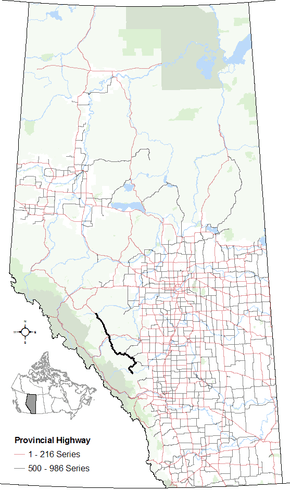
Provincial highways in Alberta
| ||||

It is preceded by the remaining central segment of Forestry Trunk Road, Highway 734 begins south of the Red Deer River to the southwest of Sundre, and is succeeded by Highway 40, which also used to be part of Forestry Trunk Road. The highway ends north of the Pembina River.
Forestry Trunk Road was a north-south resource road that ran from the Crowsnest Highway (Highway 3) in southern Alberta to Highway 43 in northern Alberta. Over time, some segments of the road have been designated as parts of Highway 40 or Highway 734, while the northernmost segment between Highway 40 and Highway 43 is no longer named Forestry Trunk Road.
Two segments of Forestry Trunk Road remain – a southern segment from the Municipality of Crowsnest Pass to Highway 541 to the southwest of Longview, and a short central segment from Highway 579 west of Cremona to south of the Red Deer River. The southern segment is preceded and succeeded by the first and second segments of Highway 40 respectively, while the central segment is preceded by the third segment of Highway 40 and succeeded by Highway 734.
Route description
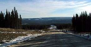
The southern remaining segment of Forestry Trunk Road begins 3.8 km (2.4 mi) north of the Crowsnest Highway (Highway 3) as a continuation of the southernmost segment of Highway 40. Over its 99 km (62 mi) length, the gravel road provides access to numerous public campgrounds, crosses the Oldman River, and intersects with Highway 532. It also passes near the Bob Creek Wildland Provincial Park, Livingstone Falls, and the Don Getty Wildland Provincial Park before ending at its intersection with Highway 541 and the second segment of Highway 40, which was part of Forestry Trunk Road before being designated a provincial highway.
Another former segment of Forestry Trunk Road, now the third segment of Highway 40, begins at Highway 1A to the west of Cochrane and ends 46 km (29 mi) later at an intersection with Highway 579. Highway 40 continues as the central remaining segment of Forestry Trunk Road for 27 km (17 mi) to a point 8 km (5.0 mi) prior to the Red Deer River. The road then continues for 268 km (167 mi) as Highway 734 to north of the Pembina River, north of the Elk River Indian reserve, where it becomes the fourth segment of Highway 40.
Over its course, the central segment of Forestry Trunk Road combined with Highway 734 provides access to Ram Falls Provincial Park and numerous campgrounds, and intersects Highway 579, Highway 584, Highway 591, Highway 752, and Highway 11 (David Thompson Highway) west of Nordegg. This stretch also crosses the Red Deer, James, Clearwater, Ram, North Saskatchewan, Blackstone, Brazeau, and Pembina rivers.
Major intersections
Starting from the south end of Highway 40:
| Rural/specialized municipality | Location | km[1] | mi | Destinations | Notes | ||
|---|---|---|---|---|---|---|---|
| Crowsnest Pass | Coleman | 0 | 0.0 | As Hwy 40 49.63639°N 114.49778°W | |||
| ↑ / ↓ | | 3.8 | 2.4 | Municipal boundary — 49.655583°N 114.479556°W | |||
| M. D. of Ranchland No. 66 | | 33 | 21 | Township Road 104A – Bob Creek Wildland Provincial Park | Former Hwy 517 49.85917°N 114.38917°W | ||
| Kananaskis I.D. (Kananaskis Country) | | 72 | 45 | 50.17972°N 114.46917°W | |||
| | 105 | 65 | 50.38306°N 114.65139°W | ||||
| 150 km (93 mi) gap | |||||||
| Rocky View County | | 254 | 158 | South end of Hwy 40 concurrency 51.22417°N 114.66000°W | |||
| M.D. of Bighorn No. 8 | Waiparous | 271 | 168 | Hummingbird Lane | 51.28417°N 114.83694°W | ||
| | 300 | 190 | North end of Hwy 40 concurrency 51.44917°N 115.03833°W | ||||
| ↑ / ↓ | | 326 | 203 | Municipal boundary — 51.62194°N 115.22444°W | |||
| Clearwater County | | 378 | 235 | 51.87111°N 115.10472°W | |||
| | 399 | 248 | 50.17972°N 114.46917°W | ||||
| | 425 | 264 | 52.07500°N 115.50083°W | ||||
| Nordegg | 515 | 320 | 52.47583°N 116.10694°W | ||||
| Yellowhead County | Elk River I.R. 233 | 583 | 362 | Lodgepole-Lovett Forestry Road | 52.93028°N 116.55944°W | ||
| | 593 | 368 | Crosses Lovett River — 52.98722°N 116.63667°W | ||||
| Coalspur | 626 | 389 | 53.17139°N 117.00750°W | ||||
1.000 mi = 1.609 km; 1.000 km = 0.621 mi
| |||||||
References
- Google (December 21, 2017). "Highway 734 / Forestry Trunk Road in Alberta" (Map). Google Maps. Google. Retrieved December 21, 2017.
- "Provincial Highways: 500 - 986 Progress Chart" (PDF). Alberta Transportation. March 2015. Retrieved July 19, 2016.