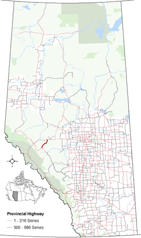
Alberta Highway 47
Alberta Provincial Highway No. 47, commonly referred to as Highway 47, is a north–south highway located in west–central Alberta, Canada that stretches from Highway 16 (Yellowhead Highway), approximately 10 km (6.2 mi) west of Edson, to Highway 40, approximately 6 km (3.7 mi) south of Robb.[2]
| ||||
|---|---|---|---|---|
 | ||||
| Route information | ||||
| Length | 60.2 km[1] (37.4 mi) | |||
| Major junctions | ||||
| South end | ||||
| North end | ||||
| Location | ||||
| Specialized and rural municipalities | Yellowhead County | |||
| Highway system | ||||
Provincial highways in Alberta
| ||||
The highway is paralleled by a spur of the Canadian National Railway that connects the main branch with the Coal Valley. It follows the McLeod River valley south of the Yellowhead Highway, then follows the Embarras River.[1]
Major intersections
From south to north. The entire route is in Yellowhead County.
| Location | km[1] | mi | Destinations | Notes | |
|---|---|---|---|---|---|
| Coalspur | 0.0 | 0.0 | |||
| Robb | 8.4 | 5.2 | |||
| Embarras | 20.6 | 12.8 | |||
| | 47.2 | 29.3 | Crosses the McLeod River | ||
| 60.2 | 37.4 | Exit 180 on Hwy 16; eastbound grade separated, westbound at-grade | |||
| Hwy 947 north (proposed) | Southern terminus of proposed Hwy 947 extension | ||||
1.000 mi = 1.609 km; 1.000 km = 0.621 mi
| |||||
gollark: Also, sadly, I think most houses lack in-wall data cables.
gollark: Network configuratiön.
gollark: Are you sure you're not just doing it wrong?
gollark: <@509348730156220427> What project is this for?
gollark: *Smart* onions.
References
- Google (March 5, 2018). "Highway 47 in Alberta" (Map). Google Maps. Google. Retrieved March 5, 2018.
- "2010 Provincial Highways 1 - 216 Progress Chart (map, 8 MB)" (PDF). Alberta Transportation. 2010. Retrieved 2010-12-31.
This article is issued from Wikipedia. The text is licensed under Creative Commons - Attribution - Sharealike. Additional terms may apply for the media files.
