Alberta Highway 40
Alberta Provincial Highway No. 40, commonly referred to as Highway 40, is a south-north highway in western Alberta, Canada.[2] It is also named Bighorn Highway and Kananaskis Trail in Kananaskis Country. Its segmented sections extend from Coleman in the Municipality of Crowsnest Pass northward to the City of Grande Prairie and is currently divided into four sections.[3]
| ||||
|---|---|---|---|---|
| Bighorn Highway, Kananaskis Trail, Forestry Trunk Road | ||||
 | ||||
| Route information | ||||
| Maintained by Alberta Transportation | ||||
| Restrictions | Annually closed between Peter Lougheed Provincial Park and Hwy 541 from December 1 - June 14.[1] | |||
| Crowsnest Pass segment | ||||
| Length | 3.8 km (2.4 mi) | |||
| South end | ||||
| North end | Forestry Trunk Road north of Coleman | |||
| Kananaskis Trail segment | ||||
| Length | 104 km (65 mi) | |||
| South end | ||||
| North end | ||||
| Forestry Trunk Road segment | ||||
| Length | 46 km (29 mi) | |||
| South end | ||||
| North end | ||||
| Northern segment | ||||
| Length | 434 km (270 mi) | |||
| South end | ||||
| Major junctions | ||||
| North end | ||||
| Location | ||||
| Specialized and rural municipalities | Crowsnest Pass, M.D. of Ranchland No. 66, Kananaskis I.D., M.D. of Bighorn No. 8, Rocky View County, Yellowhead County, M.D. Greenview No. 16, County of Grande Prairie No. 1 | |||
| Major cities | Grande Prairie | |||
| Towns | Hinton | |||
| Highway system | ||||
Provincial highways in Alberta
| ||||

.svg.png)
Route description
The southernmost section is gravel; it runs for 3.9 km (2.4 mi) through the Municipality of Crowsnest Pass, where it then becomes the Forestry Trunk Road to Highway 541, which has a combined length of 102 km (63 mi).
The second section of Highway 40 is Kananaskis Trail, which is paved and runs through Kananaskis Country for 104 km (65 mi) from Highway 541, over Highwood Pass, and through Peter Lougheed Provincial Park and Spray Valley Provincial Park. The highway passes Kananaskis Village before terminating at the Trans-Canada Highway (Highway 1).[4]
The third section is gravel and is part of the Forestry Trunk Road, which runs 46 km (29 mi) from Highway 1A to Highway 579. The highway continues as the Forestry Trunk Road and Highway 734 for approximately 293 km (182 mi), through the Rocky Mountains Forest Reserve. The intention is that one day the entire road will be a continuous paved highway. In the past, other gravel sections were named Highway 940; the 900 series in Alberta is used for temporary names. There is no signed connection between the Kananaskis Trail section and the Forestry Trunk Road section; however, it is connected by using Highway 1, Highway 1X, and Highway 1A between Seebe and Ghost Lake.
The fourth section is 434 km (270 mi) and runs from the Lovett River in Yellowhead County to the City of Grande Prairie. The 61 km (38 mi) section south of Cadomin is gravel while the remainder is paved. The highway shares 2 km (1.2 mi) concurrency with the Yellowhead Highway (Highway 16), before continuing north and passing through the Town of Grande Cache en route to Grande Prairie.[5]
Major intersections
Starting from the south end of Highway 40:
| Rural/specialized municipality | Location | km | mi | Destinations | Notes | ||
|---|---|---|---|---|---|---|---|
| Crowsnest Pass | Coleman | 0 | 0.0 | Southern terminus 49.63639°N 114.49778°W | |||
| Crowsnest Pass– M. D. of Ranchland No. 66 boundary | | 3.8 | 2.4 | Forestry Trunk Road | North end of Hwy 40 49.655583°N 114.479556°W | ||
| 101 km (63 mi) gap in Hwy 40 | |||||||
| Kananaskis I.D. (Kananaskis Country) | | 105 | 65 | Forestry Trunk Road | South end of Kananaskis Trail; south end of seasonal closure[1] 50.38306°N 114.65139°W | ||
| | 142 | 88 | Highwood Pass – el. 2,206 m (7,238 ft) — 50.599361°N 114.989500°W | ||||
| Peter Lougheed Provincial Park | 160 | 99 | Kananaskis Lakes Trail | Former Hwy 742; north end of seasonal closure;[1] 50.714444°N 115.110167°W | |||
| | 186 | 116 | Mount Allan Drive – Kananaskis Village, Nakiska | 50.93222°N 115.12667°W | |||
| | 201 | 125 | 51.04000°N 115.02917°W | ||||
| Stoney I.R. Nos. 142, 143, and 144 | | 209 | 130 | Interchange; exit 118 on Hwy 1; north end of Kananaskis Trail 51.10389°N 115.02056°W | |||
| 45 km (28 mi) gap in Hwy 40 | |||||||
| Rocky View County | | 254 | 158 | South end of Forestry Trunk Road concurrency 51.22417°N 114.66000°W | |||
| M.D. of Bighorn No. 8 | Waiparous | 271 | 168 | Hummingbird Lane | 51.28417°N 114.83694°W | ||
| | 300 | 190 | Forestry Trunk Road to Hwy 734 | North end of Hwy 40 51.44917°N 115.03833°W | |||
| 293 km (182 mi) gap in Hwy 40 | |||||||
| Yellowhead County | | 593 | 368 | South end of Big Horn Highway 52.98722°N 116.63667°W | |||
| Crosses the Lovett River | |||||||
| | 626 | 389 | 53.17139°N 117.00750°W | ||||
| | 635 | 395 | Crosses the McLeod River — 53.13917°N 117.10444°W | ||||
| Cadomin | 654 | 406 | road | Hwy 40 branches northwest 53.05361°N 117.31750°W | |||
| | 678 | 421 | Crosses the Gregg River — 53.20417°N 117.49556°W | ||||
| Hinton | 701 | 436 | Hwy 40 branches west; east end of Hwy 16 concurrency 53.37028°N 117.63722°W | ||||
| | 703 | 437 | Hwy 40 branches north; west end of Hwy 16 concurrency 53.35694°N 117.65639°W | ||||
| | 708 | 440 | Crosses the Athabasca River — 53.37750°N 117.69722°W | ||||
| | 709 | 441 | Brule Road – Brule | 53.37444°N 117.71056°W | |||
| | 726 | 451 | PAR 123 – William A. Switzer Provincial Park | 53.49028°N 117.82667°W | |||
| M.D. of Greenview No. 16 | | 805 | 500 | Road – Pierre Grey's Lakes Provincial Park | 53.90861°N 118.61667°W | ||
| Muskeg River | 810 | 500 | Forestry Trunk Road | Former Hwy 734 53.92472°N 118.67278°W | |||
| Grande Cache | 841 | 523 | Hoppe Avenue, 100 Avenue | 53.88861°N 119.11444°W | |||
| | 846 | 526 | Crosses the Smoky River — 53.89167°N 119.16472°W | ||||
| | 1,016 | 631 | Grade separated 55.07167°N 118.81278°W | ||||
| ↑ / ↓ | | 1,017 | 632 | Crosses the Wapiti River — 55.07167°N 118.80333°W | |||
| County of Grande Prairie No. 1 | | 1,021 | 634 | 55.11250°N 118.82056°W | |||
| City of Grande Prairie | 1,024 | 636 | 68 Avenue | 55.14139°N 118.82028°W | |||
| 1,026 | 638 | 84 Avenue | 55.15611°N 118.82056°W | ||||
| 1,027 | 638 | Northern terminus 55.17056°N 118.82056°W | |||||
1.000 mi = 1.609 km; 1.000 km = 0.621 mi
| |||||||
Gallery
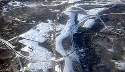 Highway 40 crossing Wapiti River south of Grande Prairie
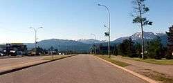 Highway 40 in Grande Cache
 Bighorn Highway, westbound, east of Grande Cache
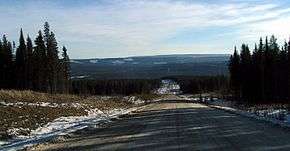 Highway 734 through the Foothills, southbound, north of Nordegg
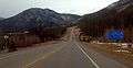 Kananaskis Trail, southbound through the Canadian Rockies in Kananaskis Country
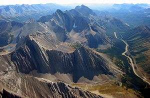 Kananaskis Trail at Highwood Pass
References
- "Annual Road Closures". Alberta Parks. Retrieved February 14, 2017.
- Provincial Highways Designation Order, Alberta Transportation, p. 7
- "2015 Provincial Highway 1-216 Progress Chart" (PDF). Alberta Transportation. March 2015. Archived (PDF) from the original on April 10, 2016. Retrieved October 12, 2016.
- Google (November 4, 2016). "Central Alberta section of Highway 40 in Alberta" (Map). Google Maps. Google. Retrieved November 4, 2016.
- Google (November 4, 2016). "Northern section of Highway 40 in Alberta" (Map). Google Maps. Google. Retrieved November 4, 2016.