Alberta Highway 855
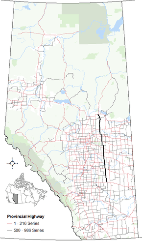
Alberta Provincial Highway No. 855[2] is a highway in the province of Alberta, Canada. It runs south-north from Highway 9 west of Hanna to Highway 55 and Highway 63 in Atmore. It provides access to rural areas, and is gravel at both its south and north ends. At 389 km (242 mi) it is the longest 500-986 series highway in Alberta.
| ||||
|---|---|---|---|---|
 | ||||
| Route information | ||||
| Maintained by Alberta Transportation | ||||
| Length | 389 km[1] (242 mi) | |||
| Major junctions | ||||
| South end | ||||
| North end | ||||
| Location | ||||
| Specialized and rural municipalities | Special Area No. 2, Stettler County No. 6, Paintearth County No. 18, Flagstaff County, Beaver County, Lamont County, Smoky Lake County, Lac La Biche County, Athabasca County | |||
| Towns | Daysland, Mundare, Smoky Lake | |||
| Highway system | ||||
Provincial highways in Alberta
| ||||

It is also known as Lougheed Avenue in Heisler, 45 Street in Daysland, 54 Street in Holden, Sawchuk Street in Mundare, and 50 Street in Andrew and Smoky Lake.
Major intersections
Starting from the south end of Highway 855:
| Rural/specialized municipality | Location | km[1] | mi | Destinations | Notes |
|---|---|---|---|---|---|
| Special Area No. 2 | | 0 | 0.0 | 51.64889°N 112.08417°W | |
| County of Stettler No. 6 | | 39 | 24 | Township Road 350 | Hwy 855 branches west; Hwy 589 concurrency begins 51.96861°N 112.13111°W |
| 40 | 25 | Hwy 855 branches north; Hwy 589 concurrency begins 51.96861°N 112.14778°W | |||
| County of Paintearth No. 18 | Halkirk | 74 | 46 | Hwy 855 branches west; Hwy 12 concurrency begins 52.27694°N 112.14806°W | |
| | 76 | 47 | Hwy 855 branches north; Hwy 12 concurrency ends 52.28167°N 112.17167°W | ||
| 90 | 56 | 52.40500°N 112.18833°W | |||
| 99 | 62 | Road – Big Knife Provincial Park | 52.47944°N 112.18556°W | ||
| ↑ / ↓ | | 100 | 62 | Crosses the Battle River — 52.48583°N 112.18389°W | |
| Flagstaff County | | 111 | 69 | Hwy 855 branches west; Hwy 53 concurrency begins 52.57944°N 112.18806°W | |
| 113 | 70 | Hwy 855 branches north; Hwy 53 concurrency ends 52.57944°N 112.21194°W | |||
| Heisler | 123 | 76 | Main Street | 52.67056°N 112.22167°W | |
| | 142 | 88 | Hwy 855 branches west; Hwy 13 concurrency begins 52.85417°N 112.22972°W | ||
| Daysland | 144 | 89 | Hwy 855 branches north; Hwy 13 concurrency ends 52.86056°N 112.25333°W | ||
| Beaver County | | 162 | 101 | 53.01778°N 112.24944°W | |
| Holden | 185 | 115 | 53.23083°N 112.24556°W | ||
| | 200 | 120 | Hwy 855 branches west; Hwy 626 concurrency begins 53.36667°N 112.24556°W | ||
| 206 | 128 | Hwy 855 branches north; Hwy 626 concurrency ends 53.36667°N 112.33806°W | |||
| Lamont County | | 229 | 142 | Hwy 15 concurrency begins 53.57028°N 112.33639°W | |
| Mundare | 232 | 144 | Hwy 15 concurrency ends 53.58972°N 112.33639°W | ||
| | 232 | 144 | 53.58972°N 112.33639°W | ||
| Andrew | 265 | 165 | Hwy 855 branches west; Hwy 45 concurrency begins 53.88944°N 112.33194°W | ||
| | 273 | 170 | Hwy 855 branches north; Hwy 45 concurrency ends 53.89000°N 112.45556°W | ||
| ↑ / ↓ | | 285 | 177 | Crosses the North Saskatchewan River — 53.99083°N 112.47639°W | |
| Smoky Lake County | Smoky Lake | 300 | 190 | 54.12139°N 112.47556°W | |
| Buffalo Lake Metis Settlement | 339 | 211 | Township Road 634 | 54.47083°N 112.45778°W | |
| Lac La Biche County | | 359 | 223 | 54.63083°N 112.42472°W | |
| Athabasca County | Atmore | 389 | 242 | Continues as Hwy 63 north 54.81944°N 112.57361°W | |
1.000 mi = 1.609 km; 1.000 km = 0.621 mi
| |||||
gollark: As Macron dictator I decided to ban global variables.
gollark: There seems to be some repolist-skin thing.
gollark: Surely nobody would willingly ONLY stare at such a bland repolist forever.
gollark: My own directory listing?
gollark: ubq already has a website.
References
- Google (April 25, 2017). "Highway 855 in Alberta" (Map). Google Maps. Google. Retrieved April 25, 2017.
- Provincial Highways Designation Order, Alberta Transportation, pp. 34–35
This article is issued from Wikipedia. The text is licensed under Creative Commons - Attribution - Sharealike. Additional terms may apply for the media files.