British Columbia Highway 1
Highway 1 is the main route of the Trans-Canada Highway (TCH) through British Columbia, Canada. Its total accumulated distance through British Columbia is 1,039 km (646 mi), including the distance travelled on ferries. It is the westernmost portion of the "Highway 1" designation of the TCH through Western Canada, which extends to the Manitoba–Ontario boundary. The Lower Mainland is the second busiest segment of the Freeway of all, which falls behind the 401 in Toronto section for freeway traffic in Canada.
| ||||
|---|---|---|---|---|
| Trans-Canada Highway | ||||
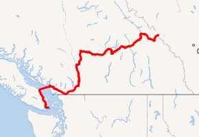
A map of southern British Columbia with Hwy 1 highlighted in red | ||||
| Route information | ||||
| Length | 1,047 km (651 mi) | |||
| Existed | 1961–present | |||
| Vancouver Island section | ||||
| Length | 116 km (72 mi) | |||
| South end | Dallas Road in Victoria | |||
| Major junctions | ||||
| North end | ||||
| Mainland section | ||||
| Length | 877 km (545 mi) | |||
| West end | ||||
| Major junctions | ||||
| East end | Alberta border at Kicking Horse Pass continues as | |||
| Highway system | ||||
British Columbia provincial highways
| ||||
.svg.png)
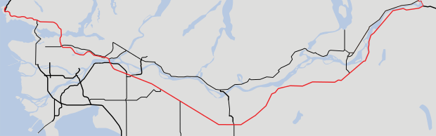
Vancouver Island section

The Vancouver Island branch of Highway 1, known locally as the Island Highway (a name shared with Highway 19), is the main thoroughfare on the south Island. The highway was first given the "1" designation in 1941, and originally went from Victoria to Kelsey Bay, a small coastal community north of Campbell River. Highway 1 on the Island was shortened to terminate in the downtown core of the city of Nanaimo in 1953, with the section north of Nanaimo being re-numbered 19. When BC Ferries took over the ferry route between Departure Bay in Nanaimo and Horseshoe Bay in West Vancouver in 1961, Highway 1 on the Island was moved to the Departure Bay ferry dock.
Route details
The Island section of Highway 1, which is 116 kilometres (72 mi) in total length, begins at the intersection of Douglas Street and Dallas Road in Victoria, where a large "mile zero" sign is erected. Highway 1 proceeds north through the city of Victoria as an urban arterial street for 4 kilometres (2.5 mi), passing by the southern terminus of Highway 17, before leaving the city at Tolmie Avenue. Once out of Victoria there are two at grade intersections at Boleskine Rd and Tillicum Rd. Highway 1 then continues on a 12 km (7.5 mi) long four to six lane freeway, with seven interchanges along its length, one of which leads to the start of Highway 14. The freeway segment ends at the signalized intersection with Westshore Parkway. After the Westshore Parkway intersection, the highway narrows to two lanes as it enters Goldstream Provincial Park. The highway from this point is known locally as Malahat Drive.
From the southern entrance to Goldstream Provincial Park, the Malahat section of Highway 1, which is known for its steep grades, goes north for 20 km (12 mi). It follows the Goldstream River through the park to the west shore of Finlayson Arm, becomes three lanes on its exit from the park, and passes through the community of Malahat proper, as well as the Malahat Summit, the highest point on the Island section of Highway 1 at 352 m (1,155 ft), en route. The Malahat portion of the highway is a mix of 2, 3 and 4 lane cross-sections. The section between Tunnel Hill and Shawnigan Lake Road is four lanes. 65 per cent of the Malahat highway is divided with concrete median. The Malahat section ends when it reaches the community of Mill Bay.
In Mill Bay, Highway 1 once again widens out into four lanes (with an interchange at Mill Bay Road at Bamberton), then passes through signalized intersections at Butterfield Road, Frayne Road and Deloume Road. Highway 1 then travels north through a gauntlet of 15 traffic lights for 29 km (18 mi). These provide access to Shawnigan Lake (stoplights at Shawnigan Lake-Mill Bay Road), Cobble Hill (Cobble Hill Road, Hutchinson Road and Fisher Road), Cowichan Bay (Cowichan Bay Road, Koksilah Road, and Bench Road) and Duncan (closely spaced signals at Allenby Road, Boys Road, Trunk Road, Coronation Avenue, James Street, Beverly Street, Green Road, and Drinkwater Road). Next is a signalized junction with Highway 18. The highway then proceeds north for 10 km (6.2 mi) through stoplights at Mays Road and Mount Sicker Road to a signalized intersection at Henry Road serving Chemainus.
From the Chemainus junction, Highway 1 travels 11 km (6.8 mi) northwest to the city of Ladysmith accessed by intersections with traffic lights at Davis Road, Roberts Street, and Ludlow Road. It then continues northwest for another 13 km (8.1 mi) through signalized junctions at Oyster Sto-Lo Road, Cedar Road, Timberlands Road, and Spitfire Way, the last of which provides access to Nanaimo Airport. The highway then reaches an unsignalized junction at Cassidy. Immediately after crossing a bridge over the Nanaimo River, there is an interchange with Nanaimo River Road. There is then a signalized intersection at Morden Road. Highway 1 enters the City of Nanaimo about 6 km (3.7 mi) north of Cassidy, where Highway 19 merges at an interchange onto the highway from the B.C. Ferry terminal at Duke Point. The two highways follow a short freeway that reaches 7 lanes at its widest point. It runs another 2 km (1.2 mi) north to a point where Highways 1 and 19 split off at a junction with Cedar Road. Highway 19 proceeds northwest to bypass Nanaimo, while Highway 1 continues north through the city of Nanaimo for 7 km (4.3 mi) to the B.C. Ferry terminal at Departure Bay, where the Island section of Highway 1 terminates.
Highway 1 then enters Departure Bay via ferry, turning east-northeast to enter the Strait of Georgia just north of Newcastle Island. The downtown core of Vancouver comes into view as the route approaches the entrance to Howe Sound. The highway then turns north-northeast just west of Passage Island to enter Queen Charlotte Channel, then rounds the Whytecliff Peninsula to enter the Horseshoe Bay ferry terminal, 57 km (31 nmi) from the Departure Bay dock.
Lower Mainland section

Like its Island section, the Highway on the Lower Mainland was first given the "1" designation in 1941. Highway 1's original alignment started out within the city limits of Vancouver, and followed Kingsway from Vancouver to Surrey, and then went along the Fraser Highway to Clearbrook. From Chilliwack, the highway originally went to Rosedale, which is a community just east of Chilliwack, along Yale Road, then along Flood-Hope Road to where it picks up its current alignment just across the Fraser River from Hope.
In 1959, Highway 1 was given an extension from within Vancouver to Horseshoe Bay by way of the Lions' Gate Bridge and Taylor Way in West Vancouver. In 1962, the section between Clearbrook and Chilliwack was re-routed to a new expressway.
In 1964, the Clearbrook–Rosedale section of Highway 1 was restored to its original alignment. Also in that year, a new expressway (or "freeway"), originally designated as Highway 401, opened up on Highway 1's current alignment between West Vancouver and Rosedale. The expressway became part of Highway 1 in 1973.
In 1986, Highway 1 between Chilliwack and Hope was improved to a freeway. Through the 1990s, all signals and intersections on Highway 1 through Greater Vancouver were removed, making the entire section of Highway 1 between Horseshoe Bay and Hope a freeway.
On June 9, 2011, Highway 1 between 152nd Street in Surrey and Highway 11 in Abbotsford was designated as the Highway of Heroes.[1]
Route details
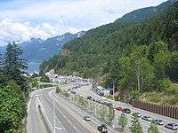
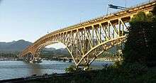
Highway 1's total length in the Lower Mainland is 170 km (110 mi). On the Mainland, the highway begins at the Horseshoe Bay ferry terminal in West Vancouver. From here to the Ironworkers Memorial Second Narrows Crossing, the highway is known locally as the Upper Levels Highway. There are nine interchanges on the 14 km (8.7 mi) stretch of the Highway within West Vancouver. The first interchange east of Horseshoe Bay brings Highway 99 onto a common alignment with Highway 1. After Taylor Way, where Highway 99 takes the exit off Highway 1, the highway crosses over the Capilano River into the District of North Vancouver. Highway 1 travels for 9 km (5.6 mi) through the District and the City of North Vancouver, passing through seven interchanges, until crossing the 1,292 m (4,239 ft) long Ironworkers Memorial Second Narrows Crossing over the Burrard Inlet into Vancouver. (The bridge, previously known as the Second Narrows Bridge, was renamed to commemorate the 27 workers who lost their lives during its construction.)
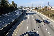
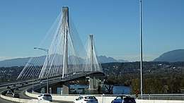
The 4-kilometre-long (2.5 mi) long stretch of Highway 1 through the eastern part of Vancouver is the only freeway within Vancouver's city limits. Highway 1 from Vancouver to Surrey is the busiest segment of the entire freeway in the Lower Mainland. In Vancouver, Highway 1 travels through the Cassiar Tunnel and passes through three interchanges leading to Downtown before crossing into Burnaby at the interchange with Boundary Road. The Burnaby stretch of Highway 1 is 11 km (6.8 mi) long, and goes through four interchanges around the city centre before proceeding into Coquitlam. The Coquitlam stretch is the widest segment in Western Canada of Highway 1. It lasts 7 km (4.3 mi), with two interchanges along its length, the westernmost of them also connecting to New Westminster. The easternmost interchange on Highway 1 in Coquitlam, known as the Cape Horn Interchange, leads to Highway 7 and Highway 7B. Leaving Coquitlam, Highway 1 crosses the Fraser River over the Port Mann Bridge into Surrey.
Sections of Highway 1 from Grandview Highway in Vancouver to 208 Street in Langley vary from being 3 to 4 lanes in each direction and shortens to two lanes after leaving Langley (Metro Vancouver) and enters Abbotsford (Fraser Valley). With one of these lanes being a high-occupancy vehicle (HOV) lane. These HOV lanes were constructed in 1998 as part of the BC MOT's "Go Green" project to promote the use of HOV vehicles, and cost $62 million.[2]
In Surrey, Highway 1 has five interchanges - 152 St (accessed by getting in rightmost lanes before the Port Mann Bridge), 156 St (HOV only), 160 St/104 Ave, one that connects to Highway 15 and Highway 17, and 192 St. 12 km (7.5 mi) east of the Highway's entry into Surrey, the Highway crosses into the Township of Langley. There are four interchanges on Highway 1 in its 18-kilometre-long (11 mi) stretch through Langley. One leads to 200 St, Langley's major thoroughfare, an HOV-only interchange leads to 202 St, another leads to Highway 10, and the final leads to Highway 13. Construction is also currently underway on another interchange within Langley at 216 St.
Highway 1 then crosses from Metro Vancouver into the Fraser Valley Regional District upon entry into Abbotsford. There are six interchanges on Highway 1 in its 33-kilometre-long (21 mi) stretch through Abbotsford, one of which leads to Highway 11. Once Highway 1 leaves Abbotsford, it crosses over the Vedder Canal into Chilliwack. The highway goes through Chilliwack for 24 km (15 mi), passing through six interchanges within the city (Yale Road West, Lickman Road, Evans Road, Vedder Road, Prest Road, and Annis Road). An exit to Young Road is also available westbound on the highway.
2 km (1.2 mi) after leaving Chilliwack, Highway 1 reaches an interchange with Highway 9. East of the Highway 9 interchange, Highway 1 hugs the south bank of the Fraser River for 35 km (22 mi), passing through seven interchanges until reaching the interchange with Highway 3 at Hope, British Columbia. Highway 1 takes the exit off the freeway at this point. (The freeway alignments of Highways 3 and 5 continue from this exit, from Exit 170 Highway 5 continues as a freeway until it meets up again with Highway 1 just west of Kamloops at Exit 362.) The vast majority of traffic travelling between Hope and Kamloops follows Highway 5 as it takes over an hour and a half less time to travel when compared to following Highway 1, and that Highway 5 is a controlled-access freeway.
Interior section

In the Kootenays, Highway 1 originally went around the Rogers Pass (British Columbia) area in its section from Revelstoke to Golden along what was known as the Big Bend Highway. In 1962, the section of Highway between Revelstoke and Golden was re-routed through Rogers Pass. This realignment reduced the travelling distance between the two towns by more than 160 km (99 mi). Over the 1970s and 1980s, Highway 1's alignment between Hope and Cache Creek underwent a massive overhaul, including new tunnels and river spans. In Kamloops, a new bypass was constructed to re-route traffic on Highway 1 around the downtown area of the city.
Route details
The Interior section of Highway 1 is 695 km (432 mi) long, and closely follows the path of the Canadian Pacific Railway. After leaving the freeway, Highway 1 courses through the town centre of Hope for 2 km (1.2 mi) before heading north across the Fraser River. At this point, Highway 1 becomes two lanes. 1 km (0.62 mi) north of the Fraser crossing, Highway 1 reaches its east junction with Highway 7. Continuing from the Highway 7 junction, Highway 1 goes 106 km (66 mi) north on a route that includes seven mountain tunnels, past the communities of Yale, Spuzzum and Boston Bar, before reaching its junction with Highway 12 at Lytton. Leaving the Fraser River, and following the Thompson River another 37 km (23 mi) northeast, Highway 1 reaches a junction with another numbered route, Highway 8. 38 km (24 mi) north of the Highway 8 junction, Highway 1 passes through a junction with Highway 97C. Continuing 5 km (3.1 mi) north, the highway reaches the community of Cache Creek, where Highway 97 merges onto the Trans-Canada from the north.
East of Cache Creek, Highways 1 and 97 proceed on their common alignment for 72 km (45 mi), passing through Savona en route to Kamloops. Highway 5 merges onto the Trans-Canada from the south at this point, returning the freeway to Highway 1.
The 1/97/5 concurrency proceeds east for 12 km (7.5 mi) on a freeway through the western part of Kamloops to where Highway 5 diverges north. Highways 1 and 97 leave Kamloops to the east 7 km (4.3 mi) later. The highway continues east for another 19 km (12 mi) to Monte Creek, where the freeway ends and Highway 97 diverges south from Highway 1. For the next 52 km (32 mi) east, Highway 1 takes a winding two-lane route through the communities of Pritchard, Chase and Sorrento. The highway widens to four lanes just east of Sorrento and remains in this alignment for the next 30 km (19 mi) before reaching the city of Salmon Arm on Shuswap Lake. Highway 97B meets Highway 1 three kilometres east of Salmon Arm's city centre.
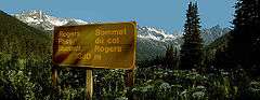
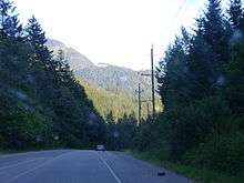
After Salmon Arm, Highway 1 goes east for 31 km (19 mi) to a junction with Highway 97A at Sicamous, following the south shore of the Salmon Arm of the Shuswap Lakes for most of this stretch. Over the next 71 km (44 mi) east, Highway 1 winds through the communities of Malakwa (the highway widens to four lanes as it passes through Malakwa), Craigellachie and the Three Valley Gap, before reaching its junction with Highway 23 at Revelstoke, on the Columbia River. The next 148 km (92 mi) of Highway 1 to Golden winds east through Mount Revelstoke National Park and Glacier National Park, where the Rogers Pass area is located. There are eight snow sheds on Highway 1 between Revelstoke and Golden—three of them lie west of Rogers Pass, while five lie to the east. Motorists are advised to check their fuel level as they are leaving either Revelstoke or Golden as there are no refuelling facilities between the two towns.
After Glacier National Park and a time zone boundary crossing, Highway 1 passes over the Columbia River again at Donald, and then reaches its junction with Highway 95 at Golden. 73 km (45 mi) east of Golden, after Highway 1 has passed through Yoho National Park and the community of Field, Highway 1 crosses the Continental Divide (via Kicking Horse Pass) into Alberta.
Major intersections
| Regional district | Location | km[3] | mi | Exit | Destinations | Notes | |
|---|---|---|---|---|---|---|---|
| Capital | Victoria | 0.00 | 0.00 | Dallas Road | Western terminus and mile zero of Trans-Canada Highway; south end of Douglas Street | ||
| 1.20 | 0.75 | Northbound right-in/right-out; BC Ferries to Vancouver (Tsawwassen) and Gulf Islands | |||||
| 1.30 | 0.81 | Black Ball Ferries to Port Angeles; Victoria Clipper passenger ferry to Seattle | |||||
| 2.10 | 1.30 | Johnson Street | One-way eastbound; access from Johnson Street Bridge | ||||
| 2.20 | 1.37 | Pandora Avenue | One-way westbound; access to Johnson Street Bridge | ||||
| 3.10 | 1.93 | Bay Street | |||||
| 3.40 | 2.11 | Gorge Road, Hillside Avenue, Government Street | Former Hwy 1A north | ||||
| ↑ / ↓ | 4.50 | 2.80 | Tolmie Avenue | ||||
| North end of City of Victoria jurisdiction | |||||||
| Saanich | 5.10 | 3.17 | Saanich Road, Boleskine Road | North end of Douglas Street | |||
| 6.44 | 4.00 | Tillicum Road | At-grade intersection, signalized | ||||
| 6.79 | 4.22 | Burnside Road | Southbound exit only | ||||
| 7.52 | 4.67 | 6 | McKenzie Avenue Interchange [4] | ||||
| South end of freeway | |||||||
| View Royal | 9.59 | 5.96 | 8 | Helmcken Road | Helmcken Road Interchange | ||
| 11.30 | 7.02 | 10 | Colwood (Island Highway, Burnside Road) | Colwood Interchange Northbound exit, southbound entrance; former Hwy 1A south | |||
| 12.24 | 7.61 | 11 | Colwood (Six Mile Road) | Thetis Interchange Southbound exit, northbound entrance | |||
| Langford | 15.29 | 9.50 | 14 | Millstream Road Interchange | |||
| 15.94 | 9.90 | 15 | McCallum Road | Northbound exit only | |||
| 16.77 | 10.42 | 16 | Leigh Road/Bear Mountain Parkway | Bear Mountain Interchange | |||
| 18.29 | 11.36 | North limit of freeway | |||||
| (18) | Westshore Parkway | ||||||
| Cowichan Valley | | 37.88 | 23.54 | (38) | Bamberton Interchange | ||
| 40.95 | 25.45 | Butterfield Road | |||||
| Mill Bay | 42.68 | 26.52 | Frayne Road | ||||
| 43.93 | 27.30 | ||||||
| 44.47 | 27.63 | Shawnigan / Mill Bay Road – Shawnigan Lake | |||||
| | 45.31 | 28.15 | Cobble Hill Road, Kilmalu Road | ||||
| 48.17 | 29.93 | Hutchinson Road – Cobble Hill, Arbutus Ridge | |||||
| 49.55 | 30.79 | Fisher Road | |||||
| 51.36 | 31.91 | Cobble Hill Road, Cowichan Bay Road – Cobble Hill, Cowichan Bay | |||||
| 55.24 | 34.32 | Koksilah Road | |||||
| 57.31 | 35.61 | Bench Road | |||||
| 59.19 | 36.78 | Wilson Road, Cowichan Bay Road – Cowichan Bay | no left turns onto highway | ||||
| Cowichan First Nation (Koksilah) | 61.01 | 37.91 | Allenby Road, Chaster Road | ||||
| 61.56 | 38.25 | Boys Road | |||||
| Duncan | 62.35 | 38.74 | Trunk Road – City Centre, Maple Bay | ||||
| 62.56 | 38.87 | Coronation Street | |||||
| North Cowichan | 62.95 | 39.12 | James Street | ||||
| 63.66 | 39.56 | Beverley Street | |||||
| 65.74 | 40.85 | Drinkwater Road | |||||
| 67.24 | 41.78 | ||||||
| 69.41 | 43.13 | Mays Road | |||||
| 74.04 | 46.01 | Hwy 1A is unsigned | |||||
| 78.42 | 48.73 | ||||||
| Ladysmith | 84.85 | 52.72 | Thicke Road, Edgelow Road | ||||
| 88.19 | 54.80 | Chemainus Road, Davis Road (Hwy 1A south) | Hwy 1A is unsigned | ||||
| 90.23 | 56.07 | Roberts Street, Transfer Beach Boulevard | |||||
| 91.16 | 56.64 | First Avenue | |||||
| Stz'uminus First Nation | 94.13 | 58.49 | Oyster Sto'Lo Road | ||||
| | 96.54 | 59.99 | Cedar Road – Yellow Point, Cedar | ||||
| Nanaimo | Cassidy | 98.02 | 60.91 | Timberlands Road | At-grade intersection, signalized | ||
| 98.98 | 61.50 | ||||||
| 101.38 | 62.99 | (102) | Nanaimo River Road, Fry Road | Nanaimo River Road Interchange | |||
| 103.52 | 64.32 | Morden Road | |||||
| Nanaimo | 105.75 | 65.71 | 7[lower-alpha 1] (106) | Duke Point Interchange South end of Hwy 19 concurrency; BC Ferries to Vancouver (Tsawwassen) | |||
| 107.69 | 66.92 | 9[lower-alpha 2] (108) | North end of Hwy 19 concurrency Partial-at grade intersection with northbound flyover to Hwy 19 north. | ||||
| 108.13 | 67.19 | Cranberry Avenue | |||||
| 108.48 | 67.41 | 10th Street, Makie Road | |||||
| 112.35 | 69.81 | ||||||
| 113.33 | 70.42 | Comox Road | |||||
| 113.61 | 70.59 | Stewart Avenue | Hwy 1 branches northeast. | ||||
| 115.67 | 71.87 | ||||||
| Strait of Georgia | |||||||
| Metro Vancouver | West Vancouver | 0.00 | 0.00 | Access via BC ferries; westbound access only | |||
| 0.35 | 0.22 | Keith Road | At-grade intersection, no westbound entrance | ||||
| West end of freeway. | |||||||
| 0.61 | 0.38 | 0 | Marine Drive | Horseshoe Bay Interchange Eastbound exit only | |||
| 1.84 | 1.14 | 2 | Eagleridge Drive to Marine Drive | Squamish Interchange Eastbound exit only; eastbound access to Hwy 99
| |||
| 2.21 | 1.37 | 3 | Eagle Ridge Interchange Westbound exit, eastbound entrance; west end of Hwy 99 concurrency | ||||
| Hwy 1 exits freeway using Exit 3. | |||||||
| 4.29 | 2.67 | 4 | Woodgreen Drive, Headland Drive | ||||
| 6.95 | 4.32 | 7 | Wentworth Avenue, Westmount Road | ||||
| 8.54 | 5.31 | 8 | Cypress Bowl Road | To Cypress Mountain Ski Area | |||
| 9.94 | 6.18 | 10 | 22nd Street | Eastbound exit only | |||
| 10.59 | 6.58 | 10 | 21st Street, Westhill Drive | No eastbound exit | |||
| 11.46 | 7.12 | 11 | 15th Street | ||||
| 13.15 | 8.17 | 13 | East end of Hwy 99 concurrency; former Hwy 1A east; to Lions Gate Bridge and Downtown Vancouver | ||||
| North Vancouver (District) | 14.59 | 9.07 | 14 | Capilano Road | To Grouse Mountain | ||
| 15.51 | 9.64 | 15 | Lloyd Avenue | Westbound right-in/right-out | |||
| North Vancouver (City) | 16.75 | 10.41 | 17 | Westview Drive | |||
| 17.92 | 11.13 | 18 | Lonsdale Avenue | ||||
| North Vancouver (District) | 19.40 | 12.05 | 19 | Lynn Valley Road | |||
| 21.37 | 13.28 | 21 | Mountain Highway | ||||
| 22.17 | 13.78 | 22 | Mount Seymour Parkway, Lillooet Road | ||||
| 22.88 | 14.22 | 23 | Main Street, Dollarton Highway | Signed as exits 23A (Main Street) and 23B (Dollarton Highway) from Hwy 1 west | |||
| ↑ / ↓ | 23.09– 24.42 | 14.35– 15.17 | Ironworkers Memorial Second Narrows Crossing over Burrard Inlet | ||||
| Vancouver | 25.03 | 15.55 | 25 | McGill Street | |||
| 26 | Hastings Street | Eastbound exit and westbound entrance; exits onto Cassiar Connector; former Hwy 7A | |||||
| 25.39– 26.13 | 15.78– 16.24 | Cassiar Tunnel | |||||
| 26.32 | 16.35 | 26 | Hastings Street | Westbound exit and eastbound entrance; exits onto Cassiar Connector; former Hwy 7A | |||
| 27.06 | 16.81 | 27 | 1st Avenue, Rupert Street | ||||
| ↑ / ↓ | 28.02 | 17.41 | 28 | Boundary Road | Eastbound exit to southbound Boundary Road and westbound entrance from northbound Boundary Road | ||
| Burnaby | 28.44 | 17.67 | 28A | Grandview Highway | Westbound exit and eastbound entrance | ||
| 28B | Grandview Highway | HOV-only interchange (left exit/entrance), westbound exit and eastbound entrance | |||||
| West end of HOV lanes | |||||||
| 29.64 | 18.42 | 29 | Willingdon Avenue | ||||
| 32.26 | 20.05 | 32 | Sprott Street | Eastbound exit, westbound entrance | |||
| 33.11 | 20.57 | 33 | Kensington Avenue, Canada Way | No access from Hwy 1 east to Kensington Avenue north | |||
| 37.38 | 23.23 | 37 | Gaglardi Way | To Simon Fraser University | |||
| 39.11 | 24.30 | 38 | Government Street | Transit-only interchange (left exit/entrance); westbound exit and eastbound entrance | |||
| Coquitlam | 40.55 | 25.20 | 40 | Brunette Avenue | To New Westminster and Pattullo Bridge | ||
| 43.68 | 27.14 | 44 | Cape Horn Interchange | ||||
| Eastbound exit and westbound entrance; westbound exit via Hwy 7 east | |||||||
| ↑ / ↓ | 44.89– 46.91 | 27.89– 29.15 | Port Mann Bridge over Fraser River | ||||
| Surrey | 48.26 | 29.99 | 48 | 152nd Street – Surrey City Centre | Eastbound exit and westbound entrance | ||
| West end of Highway of Heroes | |||||||
| 49.18 | 30.56 | 49 | 156th Street | HOV-only interchange (left exit) | |||
| 50.10 | 31.13 | 50 | 104th Avenue, 160th Street – toll centre | ||||
| 53.47 | 33.22 | 53 | BC Ferries to Victoria (Swartz Bay) and Nanaimo (Duke Point) | ||||
| 56.79 | 35.29 | 57 | 192nd Street north to unsigned Hwy 916 | Eastbound exit and westbound entrance; no access to/from 192nd Street south of interchange; eastbound access to the Golden Ears Bridge | |||
| Langley (Township) | 58.62 | 36.42 | 58 | 200th Street to unsigned Hwy 916 | Westbound access to the Golden Ears Bridge | ||
| 59.32 | 36.86 | 59 | 202nd Street | HOV-only interchange (left exit); eastbound exit, westbound entrance; future full access[5] | |||
| 60.65 | 37.69 | East end of HOV lanes | |||||
| 62.12 | 38.60 | (62) | 216th Street | New interchange under construction[5][6] | |||
| 65.73 | 40.84 | 66 | To Trinity Western University | ||||
| 73.25 | 45.52 | 73 | |||||
| Fraser Valley | Abbotsford | 82.89 | 51.51 | 83 | Former Hwy 1A west | ||
| 86.65 | 53.84 | 87 | Clearbrook Road | ||||
| 90.21 | 56.05 | 90 | McCallum Road | ||||
| 92.96 | 57.76 | 92 | Closest the Trans-Canada Highway gets to the US border in Western Canada. | ||||
| East end of Highway of Heroes | |||||||
| 95.51 | 59.35 | 95 | Whatcom Road | ||||
| 98.98 | 61.50 | 99 | South Parallel Road | Eastbound only | |||
| 104.52 | 64.95 | 104 | No. 3 Road | ||||
| Chilliwack | 110.16 | 68.45 | 109 | Yale Road | |||
| 116.05 | 72.11 | 116 | Lickman Road | ||||
| 118.19 | 73.44 | 118 | Evans Road | Eastbound exit, westbound entrance | |||
| 119.36 | 74.17 | 119 | Vedder Road | Sardis Interchange; former Hwy 1A east | |||
| 120.53 | 74.89 | 120 | Young Road | Westbound exit, eastbound entrance | |||
| 122.79 | 76.30 | 123 | Prest Road | ||||
| 129.21 | 80.29 | 129 | Annis Road | ||||
| | 135.29 | 84.07 | 135 | ||||
| 138.07 | 85.79 | 138 | Popkum Road – Popkum, Bridal Falls | ||||
| 146.35 | 90.94 | 146 | Herrling Island | ||||
| 151.54 | 94.16 | 151 | Peters Road | ||||
| 153.72 | 95.52 | 153 | Laidlaw Road – Jones Lake | ||||
| Hope | 160.09 | 99.48 | 160 | Hunter Creek Road, St. Elmo Road | |||
| 164.76 | 102.38 | 165 | Flood-Hope Road – Hope Business Route | ||||
| 167.98 | 104.38 | 168 | Flood-Hope Road | ||||
| 170.36 | 105.86 | 170 | No direct ramp from Hwy 1 west to Hwy 3/5 east; Hwy 1 branches north | ||||
| East end of freeway • Hwy 1 exits freeway using Exit 170. | |||||||
| 171.05 | 106.29 | Old Hope-Princeton Way (Hwy 915:1300 east) | Hwy 915:1300 is unsigned; westbound (southbound) access to Hwy 3 / Hwy 5 | ||||
| 172.87 | 107.42 | Water Avenue Bridge across the Fraser River | |||||
| 174.26 | 108.28 | Haig interchange | |||||
| | 196.72 | 122.24 | Yale Tunnel | ||||
| 200.70 | 124.71 | Saddle Rock Tunnel | |||||
| 206.96 | 128.60 | Sailor Bar Tunnel | |||||
| 214.89 | 133.53 | Alexandra Bridge across the Fraser River | |||||
| 218.90 | 136.02 | Alexandra Tunnel | |||||
| 223.58 | 138.93 | Hell's Gate Tunnel | |||||
| 223.90 | 139.13 | Ferrabee Tunnel | |||||
| 228.74 | 142.13 | China Bar Tunnel | |||||
| Boston Bar | 236.17 | 146.75 | Boston Bar Station Road – North Bend | ||||
| Thompson-Nicola | Lytton | 279.51 | 173.68 | ||||
| Spences Bridge | 315.11 | 195.80 | |||||
| 315.68 | 196.15 | Spences New Bridge across the Thompson River | |||||
| | 354.17 | 220.07 | Hwy 926:0901 is unsigned | ||||
| 360.17 | 223.80 | South end of Hwy 97C concurrency | |||||
| Cache Creek | 364.35 | 226.40 | Hwy 1 branches east; north end of Hwy 97C concurrency; west end of Hwy 97 concurrency | ||||
| Savona | 400.38 | 248.78 | Savona Bridge (Kamloops Lake Bridge) across the Thompson River | ||||
| Kamloops | 436.34 | 271.13 | West end of freeway • Hwy 1 / Hwy 97 exits freeway using Exit 362. | ||||
| 362 | West end of Hwy 5 concurrency | ||||||
| 440.57 | 273.76 | 366 | Copperhead Drive, Lac le Jeune Road | ||||
| 442.25 | 274.80 | 367 | Pacific Way | ||||
| 443.04 | 275.29 | 368 | Aberdeen Interchange | ||||
| 444.34 | 276.10 | 369 | Columbia Street – City Centre | Sagebrush Interchange Eastbound exit, westbound entrance | |||
| 444.92 | 276.46 | 370 | Summit Drive – City Centre | Springhill Interchange Westbound exit, eastbound entrance | |||
| 448.41 | 278.63 | 374 | Yellowhead Interchange East end of Hwy 5 concurrency | ||||
| 448.86 | 278.91 | 375 | Battle Street – City Centre | Valleyview Interchange No eastbound exit | |||
| East end of freeway | |||||||
| 450.09 | 279.67 | Vicars Road | |||||
| 451.92 | 280.81 | Oriole Road | |||||
| 451.73 | 280.69 | Highland Road | |||||
| 452.47 | 281.15 | River Road | |||||
| 453.42 | 281.74 | Tanager Road | |||||
| 454.28 | 282.28 | Grand Boulevard | |||||
| 457.49 | 284.27 | 384 | Kipp Road, Dallas Drive, Barnhartvale Road | Interchange | |||
| 462.14 | 287.16 | 386[lower-alpha 3] 388[lower-alpha 4] | Kokanee Way | Interchange | |||
| 465.83 | 289.45 | 390[lower-alpha 3] 391[lower-alpha 4] | Lafarge Road | Interchange | |||
| | 471.86 | 293.20 | 396[lower-alpha 3] 397[lower-alpha 4] | Hook Road | Interchange; westbound access to Hwy 97 south (U-turn) | ||
| 474.41 | 294.78 | 399 | Monte Creek Interchange East end of Hwy 97 concurrency; no westbound exit | ||||
| 485.72 | 301.81 | 411 | Pritchard (Pinantan Road, Stoney Flats Road) | Interchange | |||
| Chase | 501.68 | 311.73 | Shuswap Avenue (Business route) | Interchange proposed[7] | |||
| 504.06 | 313.21 | Shuswap Avenue (Business route) | Interchange proposed[7] | ||||
| Columbia-Shuswap | | 513.21 | 318.89 | Squilax-Anglemont Road (Hwy 922:0943 north) – Adams Lake, Scotch Creek, Anglemont | Partially grade separated; Hwy 922:0943 is unsigned | ||
| Sorrento | 522.30 | 324.54 | Notch Hill Road | ||||
| Blind Bay | 528.22 | 328.22 | Golf Course Drive, Cedar Drive | Interchange | |||
| | 531.83 | 330.46 | Balmoral Road, Notch Hill Road | ||||
| 534.04 | 331.84 | Broderick Creek Frontage Road, White Creek Frontage Road | Grade separated; right-in/right-out | ||||
| 535.44 | 332.71 | Broderick Creek Frontage Road, Carlin Road | Grade separated; eastbound right-in/right-out | ||||
| 535.76 | 332.91 | White Lake Road | Grade separated; westbound right-in/right-out | ||||
| Salmon Arm | 551.77 | 342.85 | Salmon River Road (Hwy 922:1126 south) | Hwy 922:1126 is unsigned; interchange proposed[8] | |||
| 557.49 | 346.41 | 21st Street NE | Eastbound exit and entrance | ||||
| 557.92 | 346.68 | 11th Avenue NE (to 21st Street NE) | Westbound exit and entrance | ||||
| 558.21 | 346.86 | 30th Street NE | |||||
| 559.84 | 347.87 | ||||||
| Sicamous | 586.68 | 364.55 | |||||
| Revelstoke | 656.38 | 407.86 | West end of Hwy 23 concurrency | ||||
| 656.93 | 408.20 | Revelstoke Bridge across the Columbia River | |||||
| 657.39 | 408.48 | Victoria Road – City Centre | |||||
| 657.82 | 408.75 | East end Hwy 23 concurrency | |||||
| | 658.73 | 409.32 | Meadows-in-the-Sky Parkway – Mount Revelstoke National Park | Interchange | |||
| Mount Revelstoke National Park | | 675.38– 687.60 | 419.66– 427.25 | Passes through Mount Revelstoke National Park | |||
| Columbia-Shuswap | | 703.17 | 436.93 | Jack MacDonald Snowshed | |||
| 704.02 | 437.46 | Twins Snowshed | |||||
| 704.78 | 437.93 | Lanark Snowshed | |||||
| Glacier National Park | | 705.41 | 438.32 | West end of Glacier National Park | |||
| 725.27 | 450.66 | Rogers Pass – 1,330 m (4,360 ft) | |||||
| 729.56 | 453.33 | Bench Snowshed | |||||
| 730.46 | 453.89 | Len's Snowshed | |||||
| 730.96 | 454.20 | Tupper #1 Snowshed | |||||
| 731.75 | 454.69 | Tupper #2 Snowshed | |||||
| 732.33 | 455.05 | Tupper Timber Snowshed | |||||
| 749.90 | 465.97 | East end of Glacier National Park | |||||
| Columbia-Shuswap | | East end of Pacific Time Zone • West end of Mountain Time Zone | |||||
| 779.63 | 484.44 | Donald Bridge across the Columbia River | |||||
| Golden | 806.13 | 500.91 | To Kicking Horse Resort ski area; interchange proposed[9] | ||||
| 807.53 | 501.78 | 780 | Golden View Road, Golden Donald Upper Road, Lafontaine Road | Interchange | |||
| | 818.44 | 508.56 | Park Bridge across the Kicking Horse River | ||||
| 830.22 | 515.87 | Wapta Road, Beaverfoot Road | Interchange | ||||
| Yoho National Park | | 830.65 | 516.14 | West end of Yoho National Park | |||
| Field | 860.09 | 534.44 | Field Access Road | ||||
| | 873.42 | 542.72 | Lake O'Hara Road | Former Hwy 1A | |||
| 877.29 | 545.12 | Kicking Horse Pass – 1,627 m (5,338 ft) | |||||
| Continental Divide; continues into Alberta | |||||||
1.000 mi = 1.609 km; 1.000 km = 0.621 mi
| |||||||
References
- TranBC (June 9, 2011). "Highway of Heroes". Ministry of Transportation and Infrastructure. Government of British Columbia. Retrieved March 9, 2018.
- "Frontier to Freeway – A short illustrated history of the roads in British Columbia". British Columbia Ministry of Transportation. Retrieved October 22, 2009.
- Landmark Kilometre Inventory (PDF). British Columbia Ministry of Transportation and Infrastructure (Report). Cypher Consulting. July 2016. pp. 399–402. Archived from the original (PDF) on March 11, 2017. Retrieved March 13, 2017.
- Trans-Canada traffic free-flowing at McKenzie interchange
- "Highway 1 and 216th Interchange Project". Ministry of Transportation and Infrastructure. Province of British Columbia. Retrieved March 8, 2017.
- 216th interchange opening delayed until 2020/
- "Highway 1 - Hoffman's Bluff to Jade Mountain". Ministry of Transportation and Infrastructure. Province of British Columbia. Retrieved January 18, 2018.
- "Highway 1 - Salmon Arm West". Ministry of Transportation and Infrastructure. Province of British Columbia. Retrieved January 18, 2018.
- "Phase 3 Design Updated - Highway 95 Interchange" (PDF). Kicking Horse Canyon Project. B.C. Ministry of Transportation and Infrastructure. April 15, 2008. Retrieved June 28, 2016.
External links
![]()
| British Columbia | ||
|---|---|---|
| Alberta | ||
| Saskatchewan | ||
| Manitoba | ||
| Ontario | ||
| Quebec | ||
| New Brunswick | ||
| Prince Edward Island | ||
| Nova Scotia | ||
| Newfoundland | ||
| ||