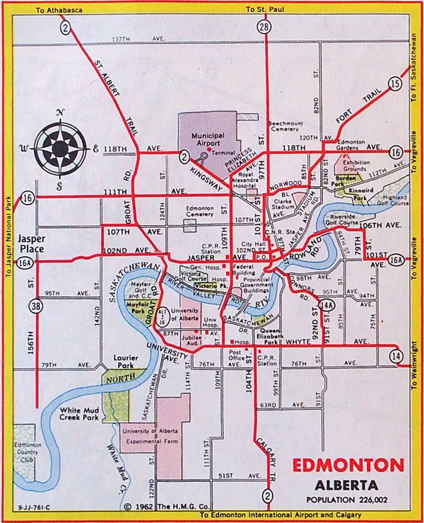
109 Street, Edmonton
109 Street is an arterial road in central Edmonton, Alberta, Canada. It takes travelers out of Downtown to the south to Old Strathcona, and to the north to the Kingsway area. It passes several Edmonton landmarks including the Garneau Theatre, Alberta Legislature Building, MacEwan University, RCMP "K" Division Headquarters, and Kingsway Mall. It is a one-way street, southbound, from 97 Avenue to Saskatchewan Drive (88 Avenue), to cross the North Saskatchewan River on the narrow High Level Bridge. Before Edmonton's amalgamation with Strathcona in 1912, the Edmonton portion was known as 9th Street while the Strathcona portion was known as 5th Street W.[1] 109 Street between Whyte Avenue and Kingsway is part of the original alignment of Highway 2 through Edmonton, the designation was moved to Whitemud Drive in the 1980s.[3]
Start/End points of 109 Street | |
| Former name(s) | 9th Street (Edmonton) 5th Street W (Strathcona)[1] |
|---|---|
| Maintained by | City of Edmonton |
| Length | 8.7 km[2] (5.4 mi) |
| Location | Edmonton |
| South end | 52 Avenue |
| Major junctions | 61 Avenue, Whyte Avenue, Saskatchewan Drive, 97 Avenue, Jasper Avenue, 111 Avenue, Kingsway Avenue |
| North end | Princess Elizabeth Avenue (City Centre Airport) |
Neighbourhoods
List of neighbourhoods 109 Street runs through, in order from south to north:[4]
Major intersections
This is a list of major intersections, starting at the south end of 109 Street.[4] The entire route is in Edmonton.
| km[2] | mi | Destinations | Notes | ||
|---|---|---|---|---|---|
| 0.0 | 0.0 | 52 Avenue | At-grade; begins as residential road | ||
| 0.5 | 0.31 | 57 Avenue | At-grade (four-way stop) | ||
| 1.0 | 0.62 | 61 Avenue (to 111 Street) | At-grade with jughandle (traffic lights); becomes arterial road | ||
| 2.6 | 1.6 | 76 Avenue | At-grade (traffic lights) | ||
| 2.8 | 1.7 | University Avenue / 78 Avenue | At-grade | ||
| 3.2 | 2.0 | Whyte (82) Avenue | At-grade (traffic lights) | ||
| 3.8 | 2.4 | At-grade (traffic lights) | |||
| 3.9 | 2.4 | At-grade (traffic lights); one-way transition | |||
| Northbound traffic follows Walterdale Hill • Southbound traffic follows 109 Street | |||||
| 88 Avenue | Southbound right-in/right-out | ||||
| 4.3– 5.1 | 2.7– 3.2 | High Level Bridge crosses the North Saskatchewan River | |||
| 5.3 | 3.3 | At-grade (traffic lights) | |||
| Two-way traffic resumes | |||||
| 5.7 | 3.5 | At-grade (traffic lights) | |||
| 6.1 | 3.8 | At-grade (traffic lights) | |||
| 6.4 | 4.0 | 102 Avenue – NorQuest College, Edmonton City Centre (mall) | At-grade (traffic lights) | ||
| 6.5 | 4.0 | 103 Avenue | At-grade (traffic lights) | ||
| 6.7 | 4.2 | 104 Avenue – MacEwan University, Rogers Place | At-grade (traffic lights) (formerly the "rathole" underpass) | ||
| 7.3 | 4.5 | 107 Avenue (Avenue of Nations) | At-grade (traffic lights) | ||
| 8.1 | 5.0 | At-grade (traffic lights) | |||
| 8.3 | 5.2 | At-grade (traffic lights) | |||
| 8.5 | 5.3 | 113 Avenue – Kingsway Mall | At-grade (traffic lights) | ||
| 8.7 | 5.4 | Princess Elizabeth Avenue (to 118 Avenue east) – NAIT | At-grade; no access to southwest-bound Princess Elizabeth Ave | ||
1.000 mi = 1.609 km; 1.000 km = 0.621 mi
| |||||
Photos
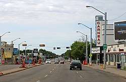 109 Street at 87 Avenue near the Garneau Theatre.
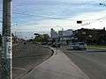 109 Street, (Garneau Theatre in center).
 109 Street leaving the High Level Bridge.
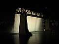 The High Level Bridge Waterfall.
References
- Mundy's Map of The Twin Cities Edmonton & Strathcona (Map). The Mundy Blueprint Co. 1911.
- Google (November 7, 2017). "109 Street in Edmonton, AB" (Map). Google Maps. Google. Retrieved November 7, 2017.
- Alberta Official Road Map (Map). Government of the Province of Alberta. 1962. Edmonton inset. Archived from the original on March 30, 2017.
- "City of Edmonton map utility". Archived from the original on 2009-06-25. Retrieved 2009-06-23.