Alberta Highway 36
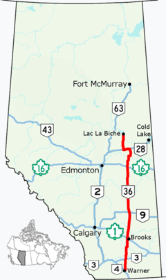
Alberta Provincial Highway No. 36, commonly referred to as Highway 36 and officially named Veterans Memorial Highway,[2] is a north-south highway in eastern Alberta, Canada that extends from Highway 4 near Warner to Highway 55 in Lac La Biche.[1] Lac La Biche County is lobbying the Government of Alberta to renumber Highway 881 to Highway 36 from Lac La Biche north to Highway 63 south of Fort McMurray.[3][4]
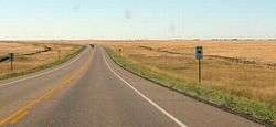
Southbound, south of Vauxhall
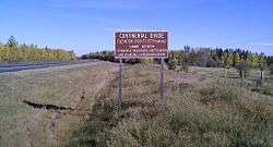
Northbound, south of Lac La Biche, marking the divide between the Arctic basin, and the Hudson Bay basin.
| ||||
|---|---|---|---|---|
| Veterans Memorial Highway | ||||
 Highway 36 highlighted in red | ||||
| Route information | ||||
| Length | 679 km[1] (422 mi) | |||
| Major junctions | ||||
| South end | ||||
| North end | ||||
| Location | ||||
| Specialized and rural municipalities | Warner No. 5 County, Taber M.D., Newell County, Special Area No. 2, Paintearth No. 18 County, Flagstaff County, Beaver County, Minburn No. 27 County, Two Hills No. 21 County, St. Paul No. 19 County, Smoky Lake County, Lac La Biche County | |||
| Towns | Taber, Vauxhall, Killam, Viking, Two Hills | |||
| Villages | Warner, Vilna | |||
| Highway system | ||||
Provincial highways in Alberta
| ||||

.svg.png)
Major intersections
From south to north:
| Rural/specialized municipality | Location | km[1] | mi | Destinations | Notes |
|---|---|---|---|---|---|
| County of Warner No. 5 | Warner | 0.0 | 0.0 | Hwy 36 southern terminus | |
| | 1.0 | 0.62 | |||
| Wrentham | 27.4 | 17.0 | |||
| M.D. of Taber | | 36.5 | 22.7 | Crosses Chin Lakes | |
| 44.8 | 27.8 | ||||
| Taber | 57.2 | 35.5 | Hwy 36 branches east; west end of Hwy 3 concurrency | ||
| 59.8 | 37.2 | Hwy 36 branches north; east end of Hwy 3 concurrency | |||
| | 80.1 | 49.8 | Crosses the Oldman River | ||
| 84.1 | 52.3 | ||||
| Vauxhall | 93.2 | 57.9 | South end of Hwy 524 concurrency | ||
| | 97.6 | 60.6 | North end of Hwy 524 concurrency | ||
| 104.1 | 64.7 | ||||
| ↑ / ↓ | | 113.9 | 70.8 | Crosses the Bow River | |
| County of Newell | | 115.7 | 71.9 | ||
| 120.3 | 74.8 | UAR 110 west – Scandia | |||
| 129.8 | 80.7 | ||||
| 143.0 | 88.9 | ||||
| 152.8 | 94.9 | ||||
| 160.1 | 99.5 | ||||
| 166.0 | 103.1 | ||||
| Duchess | 172.2 | 107.0 | |||
| | 190.3 | 118.2 | |||
| ↑ / ↓ | | 192.5 | 119.6 | Crosses the Red Deer River | |
| Special Area No. 2 | | 203.2 | 126.3 | ||
| 232.9 | 144.7 | ||||
| 259.3 | 161.1 | ||||
| 272.8 | 169.5 | Hwy 36 branches west; east end of Hwy 9 concurrency | |||
| 275.4 | 171.1 | Hwy 36 branches north; west end of Hwy 9 concurrency | |||
| 278.7 | 173.2 | Township Road 312 – Hanna | |||
| 288.4 | 179.2 | ||||
| County of Paintearth No. 18 | | 339.6 | 211.0 | ||
| 342.2 | 212.6 | South end of Hwy 599 concurrency | |||
| 344.3 | 213.9 | North end of Hwy 599 concurrency | |||
| ↑ / ↓ | | 365.0 | 226.8 | Crosses the Battle River | |
| Flagstaff County | | 368.2 | 228.8 | ||
| 378.3 | 235.1 | UAR 137 west – Galahad | |||
| 384.8 | 239.1 | ||||
| Killam | 408.7 | 254.0 | |||
| Beaver County | | 433.6 | 269.4 | Hwy 36 branches east; west end of Hwy 26 concurrency | |
| 437.5 | 271.8 | Hwy 36 branches north; east end of Hwy 26 concurrency; former Hwy 615 east | |||
| Viking | 446.0 | 277.1 | |||
| 446.2 | 277.3 | ||||
| County of Minburn No. 27 | | 483.9 | 300.7 | ||
| 496.8 | 308.7 | ||||
| County of Two Hills No. 21 | Two Hills | 516.7 | 321.1 | Hwy 36 branches east; west end of Hwy 45 concurrency | |
| | 520.5 | 323.4 | Hwy 36 branches north; east end of Hwy 45 concurrency | ||
| 527.0 | 327.5 | South end of Hwy 29 concurrency; former Hwy 637 west | |||
| Duvernay Brosseau | 528.8 | 328.6 | Crosses the North Saskatchewan River[lower-alpha 1] | ||
| County of St. Paul No. 19 | | 548.5 | 340.8 | ||
| 558.4 | 347.0 | ||||
| St. Brides | 560.0 | 348.0 | North end of Hwy 29 concurrency; former Hwy 28 east | ||
| Ashmont | 575.7 | 357.7 | Hwy 36 branches west; east end of Hwy 28 concurrency; former Hwy 28A east | ||
| | 582.7 | 362.1 | |||
| Smoky Lake County | | 598.1 | 371.6 | ||
| Vilna | 599.4 | 372.4 | UAR 116 north | ||
| | 606.9 | 377.1 | Hwy 36 branches north; west end of Hwy 28 concurrency | ||
| Kikino Metis Settlement | 642.7 | 399.4 | UAR 213 west – Kikino | ||
| Lac La Biche County | | 661.3 | 410.9 | South end of Hwy 55 concurrency | |
| Lac La Biche | 679.0 | 421.9 | Hwy 36 northern terminus; north end of Hwy 55 concurrency | ||
| 681.1 | 423.2 | 101 Avenue | Former Hwy 55 / Hwy 881 alignment | ||
1.000 mi = 1.609 km; 1.000 km = 0.621 mi
| |||||
Footnotes
- Duvernay is located on the south bank of the North Saskatchewan River and Brosseau is on the north bank.
gollark: > I hate the safety focus of modern society. We should take more risks and be less opposed to death.Well, death bad.
gollark: Like, er, NFC?
gollark: There's also obviously Bluetooth and all the various other radio communication things.
gollark: 60GHz 802.11ad can probably do *gigabits* a second at shortish distances.
gollark: > We need devices that can emit some ultra speed beeping to encode like a whole sentence of ASCII within a split second to other nearby devicesYou could just... use radio.
References
- Google (January 11, 2018). "Highway 36 in Alberta" (Map). Google Maps. Google. Retrieved January 11, 2018.
- Province of Alberta (November 11, 2005). "Highway 36 renamed Veterans Memorial Highway". Retrieved January 27, 2010.
- "Topics for Ministers Meetings" (PDF). Lac La Biche County. March 2013. Archived from the original (PDF) on July 21, 2013. Retrieved September 2, 2013.
- "2015 Provincial Highway 1-216 Progress Chart" (PDF). Alberta Transportation. March 2015. Archived (PDF) from the original on April 10, 2016. Retrieved October 12, 2016.
This article is issued from Wikipedia. The text is licensed under Creative Commons - Attribution - Sharealike. Additional terms may apply for the media files.