British Columbia Highway 16
Highway 16 is a highway in British Columbia, Canada. It is an important section of the Yellowhead Highway, a part of the Trans-Canada Highway that runs across Western Canada. The highway closely follows the path of the northern B.C. alignment of the Canadian National Railway. The number "16" was first given to the highway in 1942, and originally, the route that the highway took was more to the north of today's highway, and it was not as long as it is now. Highway 16 originally ran from New Hazelton east to an obscure location known as Aleza Lake. In 1947, Highway 16's western end was moved from New Hazelton to the coastal city of Prince Rupert, and in 1953, the highway was re-aligned to end at Prince George. In 1969, further alignment east into Yellowhead Pass was opened to traffic after being constructed up through 1968 and raised to all-weather standards in 1969. Highway 16's alignment on the Haida Gwaii was commissioned in 1984, with BC Ferries beginning service along Highway 16 to the Haida Gwaii the following year.
| ||||
|---|---|---|---|---|
| Yellowhead Highway Trans-Canada Highway | ||||
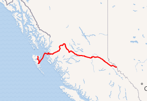
Highway 16 highlighted in red. | ||||
| Route information | ||||
| Length | 1,173 km (729 mi) | |||
| Existed | 1953–present | |||
| Haida Gwaii segment | ||||
| Length | 101 km[1] (63 mi) | |||
| North end | Masset | |||
| South end | ||||
| Mainland segment | ||||
| Length | 1,072 km[1] (666 mi) | |||
| West end | ||||
| Major junctions | ||||
| East end | Alberta border continues as | |||
| Highway system | ||||
British Columbia provincial highways
| ||||
.svg.png)
.svg.png)
A series of murders and disappearances has given the stretch between Prince Rupert and Prince George the name Highway of Tears.
Route description
Haida Gwaii section
The 101 km (63 mi) segment of the 1,347 km (837 mi)-long B.C. Highway begins in the west in the village of Masset, on the northern coast of Graham Island. Proceeding south, the highway goes 38 km (24 mi) to the inlet town of Port Clements. Winding its way along the boundary of Naikoon Provincial Park, Highway 16 goes south for 27 km (17 mi) before reaching the community of Tlell. 36 km (22 mi) south of Tlell, Highway 16 reaches Skidegate, where its Haida Gwaii section terminates.
Mainland section
BC Ferries then takes Highway 16 across the Hecate Strait for 172 km (107 mi) due northeast to its landing at Prince Rupert.
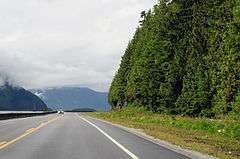
From Prince Rupert, Highway 16 begins its winding route east through the Coast Mountain Ranges. Following the Skeena River, the highway travels for 151 km (94 mi) to the city of Terrace. Highway 37 merges onto Highway 16 from north of Highway 16, at the Kitwanga junction.[2] Another 43 km (27 mi) northeast, Highway 16 reaches New Hazelton, where it then veers southeast along the Bulkley River. 68 km (42 mi) later, the highway reaches the town of Smithers, proceeding southeast another 64 km (40 mi) to the village of Houston.
At Houston, Highway 16 begins a parallel course along the upper course of the Bulkley River, proceeding 81 km (50 mi) east to its junction with Highway 35, south of Burns Lake. 128 km (80 mi) east, after passing through the hamlet of Fraser Lake, Highway 16 reaches its junction with Highway 27 in the town of Vanderhoof. 97 km (60 mi) east of Vanderhoof, Highway 16 reaches its B.C. midpoint as it enters the city of Prince George at its junction with Highway 97. Highway 16 leaves Prince George after coursing through the city for 9 km (5.6 mi).
_while_passing_through_Mt._Robson_Provincial_Park.jpg)
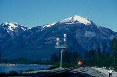
120 km (75 mi) east of Prince George, Highway 16 reaches the community of Dome Creek, where it converges with the Fraser River and turns southeast. It follows the Fraser River upstream for 82 km (51 mi) to McBride, then continues upstream for another 64 km (40 mi) to its junction with Highway 5 at Tête Jaune Cache. 14 km (8.7 mi) east of Tête Jaune Cache, Highway 16 enters Mount Robson Provincial Park, coursing through the park for 63 km (39 mi) to the boundary between British Columbia and Alberta within Yellowhead Pass.
The Highway of Tears
The Highway of Tears is a stretch of Highway 16 between Prince George and Prince Rupert.[3] Since 1970, numerous women have gone missing or have been murdered along the 720 km (450 mi) section of highway.[4] Aboriginal organizations speculate that number ranges above forty.[5] In 2006, RCMP launched Project E-Pana; a special task force that, with the exception of Shelley-Ann Bascue, originally focused on the Highway of Tears disappearances and murders.[6] The unit was originally given nine cases in 2006, expanded its scope away from Highway of Tears victims in 2007, and doubled to eighteen cases in 2007.[6] Due to budget cutbacks in the past few years, E-Pana's officers and budget have been dramatically cut. RCMP claimed that these cuts significantly hindered investigations into the Highway of Tears.[7] Not a single Highway of Tears case has been solved through E-Pana to date.[8]
Major intersections
From west to east, the following intersections are observed along Highway 16.[9] Distances exclude the 172 km (93 nmi) ferry between Skidegate and Prince Rupert.
| Regional district | Location | km[1] | mi | Destinations | Notes |
|---|---|---|---|---|---|
| Skeena-Queen Charlotte | Masset | 0.00 | 0.00 | Hodges Avenue / Towhill Road | Western terminus of the Yellowhead Highway |
| Skidegate | 100.90 | 62.70 | Oceanview Drive (Road 33) (Hwy 951:1502) – Queen Charlotte | Hwy 951:1502 is unsigned | |
| 101.19 | 62.88 | ||||
| Hecate Strait | BC Ferries from Skidegate to Prince Rupert | ||||
| Skeena-Queen Charlotte | Prince Rupert | 0.00 | 0.00 | ||
| 15.18 | 9.43 | Galloway Rapids Bridge from Kaien Island to the mainland | |||
| | 15.36 | 9.54 | Skeena Drive (Port Edward Road) (Hwy 951:1504) – Port Edward | Hwy 951:1504 is unsigned | |
| Kitimat-Stikine | Terrace | 145.91 | 90.66 | ||
| 149.31– 150.26 | 92.78– 93.37 | Dudley Little West Bridge and Dudley Little Main Bridge crosses the Skeena River | |||
| 150.50 | 93.52 | West end of Hwy 37 concurrency; former Hwy 25 | |||
| Kitwanga | 241.10 | 149.81 | East end of Hwy 37 concurrency | ||
| New Hazelton | 284.17 | 176.58 | Churchhill Street (Hwy 62 west) – Hazelton | Hwy 62 is unofficial and unsigned | |
| Bulkley-Nechako | Smithers | 349.34– 354.39 | 217.07– 220.21 | Passes through Smithers | |
| Telkwa | 366.39 | 227.66 | Passes through Telkwa | ||
| Houston | 414.19 | 257.37 | Passes through Houston | ||
| Topley | 445.08 | 276.56 | |||
| Burns Lake | 496.39 | 308.44 | |||
| Fraser Lake | 565.47 | 351.37 | Passes through Fraser Lake | ||
| | 616.66 | 383.17 | |||
| Vanderhoof | 619.87– 624.72 | 385.17– 388.18 | Passes through Vanderfoof | ||
| Fraser-Fort George | Prince George | 716.66 | 445.31 | Southridge Avenue | Interchange; no westbound entrance |
| 717.08 | 445.57 | Tyner Boulevard, Domano Boulevard | Provides access to the University of Northern British Columbia | ||
| 720.55 | 447.73 | Hwy 97 north is the John Hart Highway; Hwy 97 south is the Cariboo Highway | |||
| 722.03 | 448.65 | Victoria Street / 20th Avenue | |||
| 723.74 | 449.71 | 1st Avenue | Former Hwy 97A | ||
| 725.70 | 450.93 | Yellowhead Bridge over the Fraser River | |||
| 729.86 | 453.51 | Hwy 941:1156 is unsigned; former Hwy 97A | |||
| | 742.31 | 461.25 | Upper Fraser Road (Hwy 941:1577) – Willow River, Giscome, Upper Fraser | Hwy 941:1157 is unsigned | |
| McBride | 933.97 | 580.34 | McBride Bridge over the Fraser River | ||
| Tête Jaune Cache | 995.60 | 618.64 | Tête Jaune Interchange | ||
| Mount Robson Provincial Park | 1,009.70 | 627.40 | West end of Mount Robson Provincial Park | ||
| 1,072.37 | 666.34 | Yellowhead Pass – 1,131 m (3,711 ft) | |||
| Continues into Alberta | |||||
1.000 mi = 1.609 km; 1.000 km = 0.621 mi
| |||||
References
- Landmark Kilometre Inventory (PDF). British Columbia Ministry of Transportation and Infrastructure (Report). Cypher Consulting. July 2016. pp. 224–271. Archived from the original (PDF) on 2017-03-11. Retrieved 2017-01-06.
- Infrastructure, Ministry of Transportation and. "Highway 37 Map - Province of British Columbia". www2.gov.bc.ca. Retrieved 2019-02-02.
- Gerson, Jen. "Four things to know about Highway of Tears scandal, and the documents B.C. government allegedly deleted". National Post. Retrieved 8 December 2015.
- Ferreras, Jesse. "Highway Of Tears: BC's Missing And Murdered Women". Huffington Post. Retrieved 8 December 2015.
- "Those Who Take Us Away" (PDF). Human Rights Watch. Retrieved 8 December 2015.
- "Project E-PANA". BC RCMP.
- Culbert, Lori. "Police budget, officers cut in Highway of Tears probe". Vancouver Sun. Retrieved 8 December 2015.
- Jun 26, CBC News · Posted; June 26, 2014 5:47 PM ET | Last Updated; 2014. "'Strong suspects' but no charges in Highway of Tears investigation: RCMP | CBC News". CBC. Retrieved 2019-02-02.CS1 maint: numeric names: authors list (link)
- British Columbia Road Atlas (2007 ed.). Oshawa, ON: MapArt Publishing Corp. pp. 16–23, 26–30, 36–37. ISBN 1-55368-018-9.
External links
| Wikimedia Commons has media related to British Columbia Highway 16. |
- Official Numbered Routes in British Columbia
- Travel BC Yellowhead Highway information.
- Call for RCMP action on highway of tears
| Yellowhead Highway | ||
|---|---|---|
| Previous province: Terminus |
British Columbia |
Next province: Alberta |
| British Columbia | ||
|---|---|---|
| Alberta | ||
| Saskatchewan | ||
| Manitoba | ||
| Ontario | ||
| Quebec | ||
| New Brunswick | ||
| Prince Edward Island | ||
| Nova Scotia | ||
| Newfoundland | ||
| ||