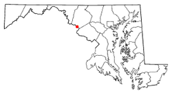
Point of Rocks, Maryland
Point of Rocks is an unincorporated community and census-designated place (CDP) in Frederick County, Maryland, United States. As of the 2010 census it had a population of 1,466.[2] It is named for the striking rock formation on the adjacent Catoctin Mountain, which was formed by the Potomac River cutting through the ridge in a water gap, a typical formation in the Appalachian Mountains. The formation is not visible from the town and can only be seen from boats on the river, or from the southern bank of the river in Virginia.
Point of Rocks, Maryland | |
|---|---|
.jpg) U.S. Route 15 crossing the Potomac River at Point of Rocks | |
 Location in Maryland | |
| Coordinates: 39°16′33″N 77°32′21″W | |
| Country | |
| State | |
| County | |
| Area | |
| • Total | 1.10 sq mi (2.85 km2) |
| • Land | 1.10 sq mi (2.85 km2) |
| • Water | 0.0 sq mi (0.0 km2) |
| Elevation | 250 ft (80 m) |
| Population (2010) | |
| • Total | 1,466 |
| • Density | 1,331/sq mi (513.9/km2) |
| Time zone | UTC−5 (Eastern (EST)) |
| • Summer (DST) | UTC−4 (EDT) |
| ZIP code | 21777 |
| Area code(s) | 301 and 240 |
| FIPS code | 24-62575 |
| GNIS feature ID | 0591032[1] |
History
Settlement and Early History
For centuries before European settlers arrived in the Point of Rocks area, indigenous populations inhabited the region. The Piscataway Nation was one of the Native American cultures to live in Point of Rocks, inhabiting an island in the Potomac River today known as Heater's Island. Forced from their homelands in modern-day Prince George's County by English settlement in the mid-18th century, the Piscataway migrated to Heater's Island around 1699, though their population was severely decreased by an outbreak of smallpox in 1704. The Piscataways remained on the island for a few more years before migrating north into Pennsylvania and New York.[3]
About a decade after the Piscataway abandoned their settlement on Heater's Island, the first European settler in Point of Rocks, Arthur Nelson, received a patent for a tract of land called "Nelson's Island."[4] The Nelson Family retained their status as prominent landholders in Point of Rocks in the early-18th century, developing several plantations on which tobacco was grown. Commercial interests in the region led the Nelsons to petition for a road to be built connecting Frederick and "Nelson's Ferry," the first English name assigned to the village that became Point of Rocks.[5] This road was eventually constructed and became known as Ballenger Creek Pike.
In the early-19th century, the arrival of the Chesapeake and Ohio (C&O) Canal and the Baltimore and Ohio (B&O) Railroad led to an increase in settlement and industry in the Point of Rocks area. The village became a temporary terminus for both the C&O Canal and the B&O Railroad in 1828 when the companies went to court to determine which would control the right of way through the narrow passage between the Potomac River and Catoctin Mountain immediately west of Point of Rocks. After six years of court battles, the companies agreed to compromise and share the right of way, the B&O Railroad eventually constructing a tunnel through the mountain to broaden its lines through the narrow water gap.[6]
With the construction of the C&O Canal and the B&O Railroad and its strategic location on the Potomac River, Point of Rocks was poised to become a regional transportation hub and center of industrial activity. In 1835, Charles Johnson, the owner of the land on which Point of Rocks was built, had lots surveyed and streets laid out for a new town.[7]
Slavery, Civil War, and Reconstruction

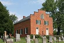
From the earliest days of European settlement in Point of Rocks, forced labor through indentured servitude and enslavement of African Americans drove the local economy. Tobacco plantations in the fertile lands of the lower Monocacy Valley were operated based on the labor of enslaved men and women. The plantation owners also used their slaves to build houses, places of business, and public buildings, such as St. Paul's Episcopal Church, completed in 1841 using the labor of enslaved men and women from the Duval Plantation. Nearby Licksville, a small community located near Noland's Ferry crossing the Potomac River was the site of an active slave market.[8]
Situated on the border between Maryland and the seceded state of Virginia, Point of Rocks was the site of several small skirmishes and military actions during the Civil War. The B&O Railroad and C&O Canal were important targets for Confederate raiders across the Potomac River. In 1861, then Colonel Thomas J. "Stonewall" Jackson led a raid at Point of Rocks, shutting off the rail lines east of the town and capturing 56 locomotives and 300 rail cars.[9]
Neighboring Loudon County was home to several small pockets of Union supporters, including Quakers who lived in villages like Waterford and Lincoln who did not support secession or the Confederate cause for defending the institution of slavery. Point of Rocks became a haven for those families who were forced to flee Virginia. In 1862, Captain Samuel C. Means, a native of Waterford, Virginia, but then living in Point of Rocks where he was a merchant and the B&O Railroad station manager, raised a cavalry unit called the Loudoun Rangers, the only organized unit from Virginia to fight for the Union.[10] The Loudoun Rangers spent most of 1862 and 1863 fighting alongside Cole's Maryland Cavalry (the First Potomac Home Brigade) to protect the C&O Canal and the B&O Railroad from frequent Confederate raids. Cole's Maryland Cavalry encamped at Point of Rocks, occupying St. Paul's Episcopal Church where they burned the interior furnishings.[11]
Lt. Col. John S. Mosby and his 43rd Battalion of Virginia Cavalry, known as "Mosby's Raiders", crossed the Potomac and attached Union garrison forces at Point of Rocks in 1864 in a brief campaign called the "Calico Raid."[9] The area was also the scene of military maneuvers and brief skirmishes during Valley Campaigns of 1864 and the Battle of Monocacy on July 9, 1864.
In the years after the Civil War, Point of Rocks remained a place of conflict. In 1879, James Carroll was lynched in Point of Rocks after being accused of breaking into the home of Richard Thomas and raping his wife. Having fled down the C&O Canal towpath to Georgetown, Carroll was apprehended on April 16, 1879. While being transported to Frederick for trial, a mob swarmed the train as it approached the station in Point of Rocks, removed Carroll from police custody, and hanged him in an adjacent field. The death of Carroll, whose alleged crimes have never been proven or disproven, was one of three recorded lynchings to take place in Frederick County.[12]
The Victorian Era
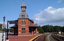
In 1873, the B&O Railroad opened its Metropolitan Branch, connecting Washington D.C. to its Old Main Line in a junction at Point of Rocks. A new station, which has become a noted town landmark, was erected the same year. The Gothic Revival styled brick building was designed by E. Francis Baldwin and is situated in the center of the junction of the two lines. Several other prominent structures were built in the town during the Victorian era, including the town's Methodist Church (1894), Holy Trinity Episcopal Church (1887, replaced in 1912), St. Luke's Lutheran Church (1889), and Masonic Temple (1898).[13]
Recent history
In 2001 Duke Energy filed an application with the Maryland Public Service Commission to construct a power plant on the north edge of town. In November 2002, however, Duke officially canceled its proposal, though it retains property in the area.[14]
The Point of Rocks railroad station was listed on the National Register of Historic Places in 1973, and St. Paul's Episcopal Church was listed in 1978.[15]
Flooding
Older portions of the town are on the Potomac River floodplain and have been repeatedly inundated. An ongoing Federal Emergency Management Agency program to reduce flood insurance payouts has resulted in the purchase and demolition of a large portion of structures on the lowest-lying properties.
Geography
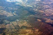
Point of Rocks is located in southern Frederick County, on the north bank of the Potomac River, and is bordered to the west by U.S. Route 15, which here runs along the eastern base of Catoctin Mountain. Via US 15 it is 13 miles (21 km) north to Frederick, the county seat, and 12 miles (19 km) south across the Potomac River to Leesburg, Virginia. Maryland Route 28 leads east from Point of Rocks through rural Frederick County and Montgomery County 29 miles (47 km) to Rockville.
According to the U.S. Census Bureau, the Point of Rocks CDP has a total area of 1.10 square miles (2.85 km2), all land.[2]
Infrastructure
Transportation
The community contains the Point of Rocks Bridge of U.S. Route 15 over the Potomac River into Virginia. The bridge is the first such crossing of the river upstream of the American Legion Memorial Bridge on I-495 in Montgomery County. The only other crossing between them is White's Ferry.
Point of Rocks is a passenger station stop on the MARC Brunswick Line. The station, designed by Ephraim Francis Baldwin, was built by the Baltimore and Ohio (B&O) Railroad and completed in 1876. Marking the junction between CSX's Metropolitan Subdivision (the current main line) and the Old Main Line Subdivision, it remains one of the former B&O's signature landmarks, and is a popular subject of railroad photography.
Notable person
- Craig Davis, author and international development expert
References
- U.S. Geological Survey Geographic Names Information System: Point of Rocks
- "Geographic Identifiers: 2010 Census Summary File 1 (G001), Point of Rocks CDP, Maryland". American FactFinder. U.S. Census Bureau. Archived from the original on February 13, 2020. Retrieved June 2, 2016.
- Curry, Dennis C. "Heater's Island and the Piscataway Indians". Our History, Our Heritage. The Maryland Historical Trust. Retrieved 25 July 2017.
- Tracey, Grace; Dern, John (1987). Pioneers of Old Monocacy: The Early Settlement of Frederick County, Maryland. Baltimore, MD: Genealogical Publishing Co., Inc. p. 59. ISBN 0-8063-1183-5.
- Tracey, Grace; Dern, John (1987). Pioneers of Old Monocacy: The Early Settlement of Frederick County, Maryland. Baltimore, MD: Genealogical Publishing Co., Inc. p. 62. ISBN 0-8063-1183-5.
- Williams, T.J.C.; McKinsey, Folger (1997). History of Frederick County, Maryland (1910). Baltimore, MD: Genealogical Publishing Co., Inc. p. 234. ISBN 0-8063-7973-1.
- Williams, T.J.C.; McKinsey, Folger (1997). History of Frederick County, Maryland (1910). Baltimore, MD: Genealogical Publishing Co., Inc. p. 322. ISBN 0-8063-7973-1.
- "Nolands Ferry". C&O Canal Trust. C&O Canal Trust.
- "Point of Rocks during the Civil War". The Historical Marker Database. Maryland Civil War Trails. Retrieved 25 July 2017.
- Crouch, Richard. "The Loudoun Rangers". The History of Loudoun County, Virginia. Waterford Foundation. Retrieved 25 July 2017.
- "History of St. Paul's Parish". St. Paul's Point of Rocks, Maryland. Retrieved 25 July 2017.
- Ashbury, John (1997). ...and all our yesterdays: A Chronicle of Frederick County, Maryland. Frederick, MD: Diversions Publications, Inc. p. 133. ISBN 0-9661278-0-3.
- Davis, Janet. "Point of Rocks Survey District" (PDF). Maryland Inventory of Historic Places. Maryland Historical Trust. Retrieved 25 July 2017.
- Maryland Public Service Commission. Baltimore, MD. "In the Matter of the Application of Duke Energy Frederick, LLC for a Certificate of Public Convenience and Necessity to Construct a 640-MW Generating Facility in Frederick County, Maryland." Archived 2011-07-25 at the Wayback Machine Case No. 8891. June 18, 2001ff.
- "National Register Information System". National Register of Historic Places. National Park Service. April 15, 2008.
External links
| Wikimedia Commons has media related to Point of Rocks, Maryland. |
.svg.png)
Municipalities and communities of Frederick County, Maryland, United States | ||
|---|---|---|
| Cities | 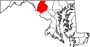 | |
| Towns | ||
| Village | ||
| CDPs | ||
| Other communities |
| |
| Footnotes | ‡This populated place also has portions in an adjacent county or counties | |