Ozaukee County, Wisconsin
Ozaukee County is a county in the U.S. state of Wisconsin. As of the 2010 census, the population was 86,395.[1] Its county seat is Port Washington.[2]
Ozaukee County | |
|---|---|
 Ozaukee County Courthouse in July 2009 | |
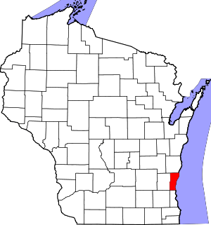 Location within the U.S. state of Wisconsin | |
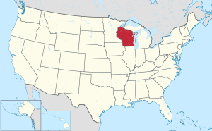 Wisconsin's location within the U.S. | |
| Coordinates: 43°23′55″N 87°53′37″W | |
| Country | |
| State | |
| Founded | 1853 |
| Seat | Port Washington |
| Largest city | Mequon |
| Area | |
| • Total | 1,116.2 sq mi (2,891 km2) |
| • Land | 233.08 sq mi (603.7 km2) |
| • Water | 883.12 sq mi (2,287.3 km2) |
| Population (2010) | |
| • Total | 86,395 |
| • Estimate (2019) | 89,221 |
| • Density | 77/sq mi (30/km2) |
| Time zone | UTC−6 (Central) |
| • Summer (DST) | UTC−5 (CDT) |
| Congressional district | 6th |
| Website | www |
Ozaukee County is included in the Milwaukee-Waukesha-West Allis, WI Metropolitan Statistical Area.
As of the 2000 Census, Ozaukee County had the 2nd lowest poverty rate of any county in the United States, at 2.6%. In terms of per capita income, it is the 25th wealthiest county in the country. Bolstered by low crime rates and school districts with high graduation rates, Forbes magazine ranked Ozaukee County #2 on its list of "America's Best Places To Raise A Family" in June, 2008.[3]
Toponymy
"Ozaukee" comes from the Ojibwe name for the Sauk people. It probably means "people living at the mouth of a river."[4]
History
The earliest evidence of humans in the Ozaukee County is the Hilgen Spring Mound Site, located in the eastern part of the city of Cedarburg, near Cedar Creek. The site consists of three conical burial mounds constructed by early Woodland period Mound Builders.[5] In 1968, archaeologists from the Milwaukee Public Museum found human burials and artifacts, including stone altars, arrowheads, and pottery shards, during an excavation of one of the mounds. Radiocarbon samples from the excavation date the mounds' construction to approximately 480 BCE, making it one of the oldest mound groups in the state.[6][7]
In the early 19th century, the Native Americans living in Ozaukee County included the Menominee, Potawatomi, and Sauk people. There were numerous Native American villages in the county along the Milwaukee River and its tributaries. The Menominee surrendered their claims to the land east of the Milwaukee River to the United States Federal Government in 1831 through the Treaty of Washington. The Potawatomi surrendered their claims to the land west of the river in 1833 through the Treaty of Chicago, which required them to leave the area by 1838. While many Potawatomi people moved west of the Mississippi River to Kansas, some chose to remain in Wisconsin, and were known as "strolling Potawatomi" because they were migrant squatters. Eventually the Potawatomi who evaded forced removal gathered in northern Wisconsin, where they formed the Forest County Potawatomi Community.[8]
The first whites in the area were primarily New England land speculators, who began purchasing land from the government in 1835 at the price of $1.25 per acre.[9] One of these land speculators was Wooster Harrison, who settled the land that would become Port Washington in 1835, which he originally named "Wisconsin City."[10][11] At the time, the land was part of Washington County, and there were proposals that Port Washington become the county seat.[12] However, Port Washington was far from the county's other early settlements, including Mequon, Grafton and Germantown. In 1850, the Wisconsin legislature voted to bisected Washington County into northern and southern counties, with Port Washington as the northern seat and Cedarburg as the southern. County residents failed to ratify the bill, and in 1853 the legislature instead bisected the county into eastern and western sections, creating Ozaukee County. Port Washington became the seat of the new county, and the Washington County seat moved to West Bend.[13]
In the 1840s, German, Irish, and Luxembourger immigrants began settling in the county. Germans were the largest ethnic group in and 19th century Ozaukee County,[14] with seven in eight residents being of German descent according to the 1870 census.[15] The earliest settlements formed around grist- and sawmills located on the county's waterways. Cedarburg, Grafton, Hamilton, Newburg, Saukville, and Thiensville all had mills by end of the 1840s. In the 19th and early 20th centuries, the county economy was primarily based on agriculture.[14]
The beginning of the American Civil War saw some chaos in Ozaukee County. The county was one of the areas affected by Wisconsin's "Great Indian Scare" of September 1862, in which some residents panicked because of unfounded rumors of a Native American uprising in the state. The panic was exacerbated by the fact that 30,000 Wisconsinites were away, serving in the war, so residents may have felt especially vulnerable. Some residents fled their homes for Milwaukee, while others holed up in makeshift fortresses, as happened at the Cedarburg Mill.[16] Several months after the panic, the United States Congress implemented the draft, which was unpopular among German immigrants with bad memories of mandatory conscription in their homelands.[17] On November 10, 1862, several hundred Port Washington residents marched on the courthouse, attacked the official in charge of implementing the draft, burned draft records, and vandalized the homes of Union supporters. The riot ended when eight detachments of Union troops from Milwaukee were deployed.[18]
Some communities in Ozaukee County grew and prospered with the construction of the Chicago, Milwaukee & St. Paul Railway in the early 1870s. From 1908 to 1948, the Milwaukee Interurban Line operated electric passenger trains between Milwaukee and Sheboygan with several stops in the county.[14]
Ozaukee County's communities experienced significant population growth during the suburbanization that followed World War II. Between 1940 and 1980, the population more than tripled, from 18,985 to 66,981. While the Interurban declined and ceased operation after the war, the construction of Interstate 43 in the mid-1960s allowed more residents to commute for work.[14] Communities that experienced the most significant population growth, such as Cedarburg and Grafton, began to annex agricultural land for residential subdivisions and commercial developments.[19] The previously rural Town of Mequon became increasingly suburban and incorporated in 1957 as the City of Mequon. Today, it is the largest and most populous city in Ozaukee County.
Geography
Ozaukee County covers 233 square miles of land, making it the second smallest county in Wisconsin by land area after Pepin County. The county's jurisdiction also extends over 883 square miles of water, most of which is in Lake Michigan.[20][21]
Lion's Den Gorge Nature Preserve is a large bluffland and wetland county protected area on the shore of Lake Michigan.
Major highways


Adjacent counties
- Sheboygan County - north
- Oceana County, Michigan - northeast
- Muskegon County, Michigan - east
- Milwaukee County - south
- Waukesha County - southwest
- Washington County - west
Demographics
| Historical population | |||
|---|---|---|---|
| Census | Pop. | %± | |
| 1860 | 15,682 | — | |
| 1870 | 15,564 | −0.8% | |
| 1880 | 15,461 | −0.7% | |
| 1890 | 14,943 | −3.4% | |
| 1900 | 16,363 | 9.5% | |
| 1910 | 17,123 | 4.6% | |
| 1920 | 16,335 | −4.6% | |
| 1930 | 17,394 | 6.5% | |
| 1940 | 18,985 | 9.1% | |
| 1950 | 23,361 | 23.0% | |
| 1960 | 38,441 | 64.6% | |
| 1970 | 54,421 | 41.6% | |
| 1980 | 66,981 | 23.1% | |
| 1990 | 72,831 | 8.7% | |
| 2000 | 82,317 | 13.0% | |
| 2010 | 86,395 | 5.0% | |
| Est. 2019 | 89,221 | [22] | 3.3% |
| U.S. Decennial Census[23] 1790–1960[24] 1900–1990[25] 1990–2000[26] 2010–2019[1] | |||


As of the census[27] of 2000, there were 82,317 people, 30,857 households, and 23,019 families residing in the county. The population density was 355 people per square mile (137/km²). There were 32,034 housing units at an average density of 138 per square mile (53/km²). The racial makeup of the county was 96.72% White, 0.93% Black or African American, 0.20% Native American, 1.07% Asian, 0.02% Pacific Islander, 0.34% from other races, and 0.73% from two or more races. 1.30% of the population were Hispanic or Latino of any race. 47.2% were of German, 7.3% Irish and 6.7% Polish ancestry. 95.1% spoke English, 1.6% Spanish and 1.4% German as their first language.
There were 30,857 households out of which 36.00% had children under the age of 18 living with them, 65.60% were married couples living together, 6.50% had a female householder with no husband present, and 25.40% were non-families. 21.40% of all households were made up of individuals and 8.40% had someone living alone who was 65 years of age or older. The average household size was 2.61 and the average family size was 3.07.
In the county, the population was spread out with 26.60% under the age of 18, 6.80% from 18 to 24, 28.00% from 25 to 44, 25.90% from 45 to 64, and 12.60% who were 65 years of age or older. The median age was 39 years. For every 100 females there were 97.30 males. For every 100 females age 18 and over, there were 94 males.
The median income for a household in the county was $62,745, and the median income for a family was $72,547 (these figures had risen to $73,197 and $88,231 respectively as of a 2007 estimate[28]). Males had a median income of $50,044 versus $30,476 for females. The per capita income for the county was $31,947. About 1.7% of families and 2.6% of the population were below the poverty line, including 2.6% of those under age 18 and 4.1% of those age 65 or over.
Transportation
Ozaukee County has a harbor in Port Washington on Lake Michigan, though not in the lakeside communities of Mequon or Grafton due to high bluffs along the lakeshore.
The Ozaukee County Interurban Trail is a multimodal trail for pedestrians and non-motorized vehicles. It runs through Grafton and connects to Sheboygan County and Brown Deer Trails via the old Milwaukee-Sheboygan Passenger Rail line.
Public transit is provided by a commuter express bus (Route 143) to Milwaukee with stops in Port Washington, Saukville, Grafton, and Mequon. The bus operates Monday through Fridays excluding holidays, and is run jointly by Milwaukee and Ozaukee County. The county offers a daily shared taxi, with connections to Washington County Transit and Milwaukee County Routes 12, 49 and 42u.
Politics
As one of the suburban counties surrounding Milwaukee, Ozaukee County is a Republican stronghold in U.S. presidential elections, having voted Republican in all elections (except one) since 1940. Lyndon B. Johnson was the last Democrat to carry the county in a presidential election, in 1964.[29]
| Year | Republican | Democratic | Third parties |
|---|---|---|---|
| 2016 | 55.8% 30,464 | 37.0% 20,170 | 7.2% 3,926 |
| 2012 | 64.6% 36,077 | 34.3% 19,159 | 1.0% 581 |
| 2008 | 60.3% 32,172 | 38.6% 20,579 | 1.2% 614 |
| 2004 | 65.8% 34,904 | 33.4% 17,714 | 0.8% 414 |
| 2000 | 65.2% 31,155 | 31.5% 15,030 | 3.3% 1,566 |
| 1996 | 56.7% 22,078 | 34.1% 13,269 | 9.3% 3,614 |
| 1992 | 53.2% 22,805 | 27.7% 11,879 | 19.2% 8,226 |
| 1988 | 63.9% 22,899 | 35.4% 12,661 | 0.7% 252 |
| 1984 | 68.5% 23,898 | 30.9% 10,765 | 0.7% 233 |
| 1980 | 61.0% 21,371 | 30.8% 10,779 | 8.2% 2,883 |
| 1976 | 62.2% 19,817 | 35.4% 11,271 | 2.5% 789 |
| 1972 | 61.9% 15,759 | 33.4% 8,503 | 4.7% 1,204 |
| 1968 | 58.1% 12,155 | 34.6% 7,246 | 7.3% 1,518 |
| 1964 | 47.4% 8,581 | 52.5% 9,517 | 0.1% 25 |
| 1960 | 58.9% 10,401 | 40.9% 7,228 | 0.2% 28 |
| 1956 | 69.6% 9,808 | 29.4% 4,139 | 1.0% 139 |
| 1952 | 67.0% 8,665 | 32.8% 4,241 | 0.3% 33 |
| 1948 | 52.9% 4,866 | 45.2% 4,159 | 2.0% 183 |
| 1944 | 60.7% 5,655 | 38.4% 3,579 | 1.0% 89 |
| 1940 | 56.3% 4,913 | 42.0% 3,662 | 1.7% 148 |
| 1936 | 22.5% 1,785 | 70.7% 5,594 | 6.8% 539 |
| 1932 | 16.5% 1,182 | 80.6% 5,770 | 2.9% 208 |
| 1928 | 37.2% 2,338 | 61.4% 3,864 | 1.4% 90 |
| 1924 | 20.7% 1,015 | 12.1% 592 | 67.2% 3,293 |
| 1920 | 75.6% 3,523 | 17.9% 835 | 6.5% 302 |
| 1916 | 49.4% 1,610 | 48.4% 1,577 | 2.2% 71 |
| 1912 | 25.2% 749 | 63.3% 1,878 | 11.5% 341 |
| 1908 | 38.5% 1,216 | 58.7% 1,856 | 2.8% 88 |
| 1904 | 47.5% 1,492 | 47.8% 1,501 | 4.7% 147 |
| 1900 | 38.4% 1,280 | 59.8% 1,992 | 1.8% 60 |
| 1896 | 42.8% 1,535 | 54.3% 1,947 | 2.9% 105 |
| 1892 | 23.3% 652 | 74.7% 2,094 | 2.0% 57 |
Communities
Cities
- Cedarburg
- Mequon
- Port Washington (county seat)
Villages
- Bayside (mostly in Milwaukee County)
- Belgium
- Fredonia
- Grafton
- Newburg (mostly in Washington County)
- Saukville
- Thiensville
Census-designated place
Unincorporated communities
Ghost town
References
- "State & County QuickFacts". United States Census Bureau. Archived from the original on July 16, 2011. Retrieved January 22, 2014.
- "Find a County". National Association of Counties. Retrieved June 7, 2011.
- "America's Best Places To Raise A Family". Forbes. June 30, 2008.
- "Ozaukee County". Wisconsin Historical Society. Retrieved April 10, 2018.
- "Ecological Landscapes of Wisconsin: Central Lake Michigan Coastal Ecological Landscape" (PDF). Wisconsin Department of Natural Resources. Retrieved February 13, 2020.
- "Searching for the 'Spirit of the Place'". Shepherd Express. Retrieved 2020-01-18.
- "Hilgen Spring Mound Site Revisited: Lecture". Localeben. Retrieved 2020-01-18.
- "Potawatomi History". Milwaukee Public Museum. Retrieved February 20, 2020.
- "History of Ozaukee County". Ozaukee County. Retrieved 2020-01-11.
- Sister M. Jane Frances Price, S.S.N.S., The History of Port Washington, in Ozaukee County, Wisconsin (Ph.D. diss., De Paul University, 1943), pp. 7-8.
- Chicago and North Western Railway Company (1908). A History of the Origin of the Place Names Connected with the Chicago & North Western and Chicago, St. Paul, Minneapolis & Omaha Railways. p. 115.
- "History of Ozaukee County"
- "Encyclopedia of Milwaukee: Ozaukee County". University of Wisconsin-Milwaukee. Retrieved January 11, 2020.
- "Encyclopedia of Milwaukee: Ozaukee County"
- "Early history of Ozaukee County, Wisconsin". University of Wisconsin-Madison Libraries. Retrieved 2020-01-11.
- "Early history of Ozaukee County, Wisconsin". University of Wisconsin-Madison Libraries. Retrieved January 1, 2020.
- "Civil War: Draft Riots (1862)". Wisconsin Historical Society. Retrieved January 4, 2020.
- Gurda, John (1999). "Chapter 3. Here Come the Germans, 1846-1865". The Making of Milwaukee. Milwaukee County Historical Society. p. 97.
- "Encyclopedia of Milwaukee: Village of Grafton". University of Wisconsin-Milwaukee. Retrieved January 2, 2020.
- "2010 Census Gazetteer Files". United States Census Bureau. August 22, 2012. Retrieved August 8, 2015.
- "Overview of Ozaukee County | Ozaukee County, WI - Official Website". www.co.ozaukee.wi.us. Retrieved September 19, 2018.
- "Population and Housing Unit Estimates". Retrieved March 26, 2020.
- "U.S. Decennial Census". United States Census Bureau. Retrieved August 6, 2015.
- "Historical Census Browser". University of Virginia Library. Retrieved August 6, 2015.
- Forstall, Richard L., ed. (March 27, 1995). "Population of Counties by Decennial Census: 1900 to 1990". United States Census Bureau. Retrieved August 6, 2015.
- "Census 2000 PHC-T-4. Ranking Tables for Counties: 1990 and 2000" (PDF). United States Census Bureau. April 2, 2001. Retrieved August 6, 2015.
- "U.S. Census website". United States Census Bureau. Retrieved May 14, 2011.
- "Ozaukee County, Wisconsin - Fact Sheet - American FactFinder". Factfinder.census.gov. Archived from the original on February 11, 2020. Retrieved July 22, 2010.
- Leip, David. "Dave Leip's Atlas of U.S. Presidential Elections". uselectionatlas.org. Retrieved April 11, 2018.
Further reading
- History of Washington and Ozaukee Counties, Wisconsin. Chicago: Western Historical Company, 1881.
External links
- Ozaukee County website
- Ozaukee County map from the Wisconsin Department of Transportation
- Ozaukee County Transit
- Ozaukee County Interurban Trail
Places adjacent to Ozaukee County, Wisconsin | ||||||||||
|---|---|---|---|---|---|---|---|---|---|---|
| ||||||||||
| Central city |  | |
|---|---|---|
| Largest municipalities (over 25,000 in 2010) | ||
| Municipalities (over 10,000 in 2010) | ||
| Smaller municipalities (under 10,000 in 2010) |
| |
| Counties | ||
| Other topics | ||
Notes: Vvillage Ttown Ccity | ||
Municipalities and communities of Ozaukee County, Wisconsin, United States | ||
|---|---|---|
| Cities | | |
| Villages | ||
| Towns | ||
| CDP | ||
| Unincorporated communities | ||
| Ghost towns | ||
| Footnotes | ‡This populated place also has portions in an adjacent county or counties | |
| Authority control |
|
|---|