Babinda
Babinda is a small town and locality in the Cairns Region, Queensland, Australia.[2][3] It is located 60 kilometres (37 mi) south of Cairns.
| Babinda Queensland | |||||||||||||||
|---|---|---|---|---|---|---|---|---|---|---|---|---|---|---|---|
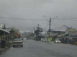 Babinda on a typical rainy day | |||||||||||||||
 Babinda | |||||||||||||||
| Coordinates | 17°20′42″S 145°55′30″E | ||||||||||||||
| Population | 1,253 (2016 census)[1] | ||||||||||||||
| • Density | 31.40/km2 (81.33/sq mi) | ||||||||||||||
| Established | circa 1880 - circa 1900 | ||||||||||||||
| Postcode(s) | 4861 | ||||||||||||||
| Elevation | |||||||||||||||
| Area | 39.9 km2 (15.4 sq mi) | ||||||||||||||
| Location | |||||||||||||||
| LGA(s) | Cairns Region | ||||||||||||||
| State electorate(s) | Hill | ||||||||||||||
| Federal Division(s) | Kennedy | ||||||||||||||
| |||||||||||||||
| |||||||||||||||
The town is noted for its proximity to Queensland's two highest mountains Mount Bartle Frere and Mount Bellenden Ker.
Babinda and Tully annually compete for the Golden Gumboot, an award for Australia's wettest town. Babinda is usually the winner, recording an annual average rainfall of over 4279.4 millimetres each year.[4]
History
Babinda takes its name from the local Indigenous Australian language for mountain.[5] Other sources, however, claim it is a Yidinji word for water, possibly referring to the high rainfall of the area.[2][6]
Babinda State School opened on 4 November 1914.[7]
Babinda Post Office opened by 1915 (a Babinda Creek receiving office had been open since 1891).[8]
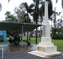
The Babinda War Memorial was unveiled by the chairman of the Cairns Shire Council Seymour Warner on 25 April 1927.[9]
The Babinda Public Library building opened in 1955.[10]
In March 2006, Babinda was struck by Cyclone Larry, damaging up to 80% of buildings.[11]
At the 2011 census the town recorded a population of 1,068.[12]
Heritage listings
Babinda has a number of heritage-listed sites, including:
- 65-85 Munro Street: Babinda Hotel[13]
- 109 Munro Street: Babinda Air Raid Shelter[14]
Demographics
The 2006 Census by the Australian Bureau of Statistics counted 1,167 persons in Babinda on census night. Of these, 49.7% were male and 50.3% were female.[15]
The majority of residents (79.7%) are of Australian birth, with other common census responses being Italy (2.7%) and New Zealand (2.0%).[15]
The age distribution of Babinda residents is skewed slightly higher than the greater Australian population. 70.1% of residents were over 25 years in 2006, compared to the Australian average of 66.5%; and 29.9% were younger than 25 years, compared to the Australian average of 33.5%.[15]
Community
The local newspapers are the The Cairns Post or the Wet Tropic Times. There are many different community events in Babinda. The annual Harvest Festival is celebrated in October and features some unusual events including the Sugar Bowl competition, the Gumboot Toss and the Umbrella Toss (reflecting Babinda's connection to the sugar industry and its wet weather). The festival has been running since the 1960s but did not occur in 2006 due to Cyclone Larry.[16][17][18]
Schools
Babinda is served by Babinda P-12 State School, on the corner of Pollard and the Boulders Road.[19][7] Also St Rita's School, on Church Street, Babinda Kindergarten also on Church Street and Babinda Early Learning on Pollard Road.
Amenities
The Cairns Regional Council operates a public library in Babinda at 24 Munro Street.[20]
The Babinda branch of the Queensland Country Women's Association meets at the QCWA Hall in School Road.[21]
Attractions
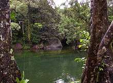
The Boulders and Devil's Pool are popular tourist attractions. A picnic area is located nearby, beside Babinda Creek.
Transportation
Babinda is situated on the Bruce Highway. The town has a railway station for access to the long-distance train services, currently only the Spirit of Queensland for which an advance booking must be made for the train to stop in Babinda.[22]
Climate
Babinda has a tropical rainforest climate (Af) with humid and persistently wet weather. It is well known and recognised as the wettest town in Australia, with an annual average rainfall of 4279.4 mm. Monthly totals over 1000 mm are not uncommon, and sometimes, usually between January and April, whole months will go by without a single sunny day.
The wet season lasts from December to May, while the 'dry season' occurs from June to November. During the wet season, heavy monsoonal downpours occur almost daily and occasionally even heavier rain from tropical lows or cyclones occurs. Rainfall still totals well over 100mm a month during the dry season; however, it is usually in the form of coastal showers, which can range from 1 or 2 millimeters, to brief downpours of 100mm or more. Thunderstorms with dangerous lightning and damaging winds can be a threat from October to December; however, this threat decreases when the monsoon begins to take over in January.
| Climate data for Babinda Post Office | |||||||||||||
|---|---|---|---|---|---|---|---|---|---|---|---|---|---|
| Month | Jan | Feb | Mar | Apr | May | Jun | Jul | Aug | Sep | Oct | Nov | Dec | Year |
| Average high °C (°F) | 30.6 (87.1) |
30.4 (86.7) |
29.5 (85.1) |
28.0 (82.4) |
26.1 (79.0) |
24.3 (75.7) |
23.8 (74.8) |
24.9 (76.8) |
26.5 (79.7) |
28.0 (82.4) |
29.4 (84.9) |
30.4 (86.7) |
27.7 (81.8) |
| Average low °C (°F) | 23.2 (73.8) |
23.3 (73.9) |
22.5 (72.5) |
21.0 (69.8) |
19.0 (66.2) |
16.7 (62.1) |
15.7 (60.3) |
16.2 (61.2) |
17.6 (63.7) |
19.6 (67.3) |
21.5 (70.7) |
22.7 (72.9) |
19.9 (67.9) |
| Average precipitation mm (inches) | 644.9 (25.39) |
744.9 (29.33) |
801.0 (31.54) |
535.1 (21.07) |
348.2 (13.71) |
202.1 (7.96) |
143.9 (5.67) |
113.2 (4.46) |
123.5 (4.86) |
125.1 (4.93) |
190.6 (7.50) |
306.9 (12.08) |
4,279.4 (168.5) |
| Source: bom.gov.au[23] | |||||||||||||
References
- Australian Bureau of Statistics (27 June 2017). "Babinda (State Suburb)". 2016 Census QuickStats. Retrieved 23 January 2018.

- "Babinda (entry 1081)". Queensland Place Names. Queensland Government. Retrieved 20 March 2014.
- "Babinda (entry 45553)". Queensland Place Names. Queensland Government. Retrieved 20 March 2014.
- Geiger, Dominic (14 December 2016). "Bets on Babinda in race to record rainfall gold". Mackay Mercury. Retrieved 6 May 2017.
- (31 October 2001). What's in a name? – 3 Archived 8 January 2014 at the Wayback Machine. Australian Broadcasting Corporation. Retrieved 8 January 2014.
- Babinda Archived 10 March 2012 at the Wayback Machine. Cairns Connect. Retrieved 8 January 2014.
- "Opening and closing dates of Queensland Schools". Queensland Government. Retrieved 18 April 2019.
- Premier Postal History. "Post Office List". Premier Postal Auctions. Retrieved 10 May 2014.
- "Babinda War Memorial". Monument Australia. Archived from the original on 7 April 2014. Retrieved 3 April 2014.
- "Queensland Public Libraries Statistical Bulletin 2016-2017" (PDF). Public Libraries Connect. State Library of Queensland. November 2017. Archived (PDF) from the original on 30 January 2018. Retrieved 24 January 2018.
- "Larry's catastrophic toll". The Courier-Mail. 20 March 2006. Archived from the original on 26 June 2006. Retrieved 21 March 2006.
- Australian Bureau of Statistics (31 October 2012). "Babinda (State Suburb)". 2011 Census QuickStats. Retrieved 8 January 2014.
- "Babinda Hotel (entry 602189)". Queensland Heritage Register. Queensland Heritage Council. Retrieved 7 July 2013.
- "Babinda Air Raid Shelter (entry 602743)". Queensland Heritage Register. Queensland Heritage Council. Retrieved 7 July 2013.
- Australian Bureau of Statistics (25 October 2007). "Babinda (Cairns City) (State Suburb)". 2006 Census QuickStats. Retrieved 30 March 2011.
- "Babinda Harvest Festival". Archived from the original on 15 September 2014. Retrieved 15 September 2014.
- "Babinda Harvest Festival". Northern Greenhouse, Cairns. Archived from the original on 1 March 2015. Retrieved 15 September 2014.
- "Operation Recovery Update: Issue 44" (PDF). Queensland Government. July 2007. Archived (PDF) from the original on 15 September 2014. Retrieved 15 September 2014.
- "Babinda State School". Archived from the original on 1 February 2018. Retrieved 1 February 2018.
- "Babinda Library". Public Libraries Connect. State Library of Queensland. 25 March 2015. Archived from the original on 24 January 2018. Retrieved 24 January 2018.
- "Branch Locations". Queensland Country Women's Association. Archived from the original on 26 December 2018. Retrieved 26 December 2018.
- Spirit of Queensland timetable Archived 10 December 2018 at the Wayback Machine Traveltrain 15 October 2018
- "Climate Statistics for Babinda, QLD". Archived from the original on 24 September 2015. Retrieved 9 October 2013.
External links
| Wikimedia Commons has media related to Babinda, Queensland. |
- University of Queensland: Queensland Places: Babinda
- Watch historical footage of Babinda, Cairns and Far North Queensland from the National Film and Sound Archive of Australia's collection
- Bell, Peter (1999). "History of Babinda". Academia.
- "Babinda". The Age. Melbourne, Australia. 8 February 2004. Retrieved 30 March 2011.