Cardwell, Queensland
Cardwell is a tropical coastal town and locality in the Cassowary Coast Region in Far North Queensland, Australia.[3][4] In the 2016 census, Cardwell had a population of 1,309 people.[1] The Bruce Highway National Highway 1 and the North Coast railway line are the dominant transport routes; connecting with the Queensland provincial cities of Cairns and Townsville. Cardwell suffered significant damage from Cyclone Yasi, a category 5 cyclone, in February 2011.[5][6]
| Cardwell Queensland | |||||||||||||||
|---|---|---|---|---|---|---|---|---|---|---|---|---|---|---|---|
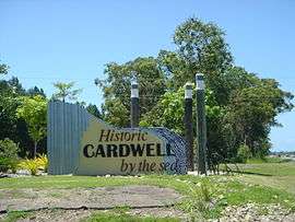 Entrance to Cardwell, Highway 1 | |||||||||||||||
 Cardwell | |||||||||||||||
| Coordinates | 18°15′51″S 146°01′33″E | ||||||||||||||
| Population | 1,309 (2016 census)[1] | ||||||||||||||
| Postcode(s) | 4849 | ||||||||||||||
| Elevation | 5 m (16 ft)[2] | ||||||||||||||
| Location | |||||||||||||||
| LGA(s) | Cassowary Coast Region | ||||||||||||||
| State electorate(s) | Hinchinbrook | ||||||||||||||
| Federal Division(s) | Kennedy | ||||||||||||||
| |||||||||||||||
| |||||||||||||||
Geography
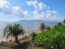
West of Cardwell the rugged topography of the Cardwell Range intercepts the trade winds resulting in high rainfall. The coastal escarpment is covered in rainforest which transitions to the west to eucalypt woodland and tropical savanna. Cardwell Range biodiversity has been protected by the introduction of Forestry Reserves, National Parks and Queensland World Heritage Wet Tropics Areas. Seaward lies the Coral Sea, the Great Barrier Reef and Lagoon, Rockingham Bay and Hinchinbrook Channel. Islands are visible from Cardwell including protected areas i.e. Hinchinbrook Island, Goold Island and the Brook Islands Group.
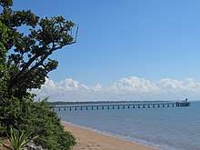
Oyster Point is one kilometre south of Cardwell. This location experienced one of Australia's important conservation battles.[7] With the establishment of Port Hinchinbrook, the Marina Public Boat Ramp provides year round access to the protected marine environments of Hinchinbrook Channel, Estuaries, Islands and Great Barrier Reef. The Cardwell Jetty is an important infrastructure asset, where visitors can socialize and view the coastal scenery; and anglers can enjoy both day and evening fishing activities.
History
The Aboriginal heritage is defined by Language Groups; the boundary of the Dyirbal and Warrgamay lies between Cardwell and Tully in the north.
Warrgamay (also known as Waragamai, Wargamay, Wargamaygan, Biyay, and Warakamai) is an Australian Aboriginal language in North Queensland. The language region includes the Herbert River area, Ingham, Hawkins Creek, Long Pocket, Herbert Vale, Niagara Vale, Yamanic Creek, Herbert Gorge, Cardwell, Hinchinbrook Island and the adjacent mainland.[8]
Girramay (also known as Giramay, Garamay, Giramai, Keramai) is a language of Far North Queensland, particularly the area around Herbert River Catchment taking in the towns of Cardwell and Ingham. The Girramay language region includes the landscape within the local government boundaries of Cassowary Coast and Hinchinbrook Regional Councils.[9]
The first Europeans settled in the area in January 1864 in order to create a port initially called "Port Hinchinbrook". Subsequently, the town was renamed Cardwell later in 1864 by explorer George Elphinstone Dalrymple after Edward Cardwell, 1st Viscount Cardwell, the Secretary of State for the Colonies at that time.[3]
Cardwell was the first port settlement on the Queensland coast north of Port Denison (Bowen). The first party of non-indigenous people to settle at Rockingham Bay arrived in January 1864 and was led by George Elphinstone Dalrymple.[10] They were 20 in number including James Morrill, William Alcock Tully, Arthur Jervoise Scott, Lieut. Marlow of the Native Police and his troopers Norman, Archy and Warbragen. Dalrymple also brought his "black boy" servant, an Aboriginal man from Stradbroke Island that he called "Cockey". They came from Bowen on the small schooner Policeman which was under the command of ex-Native Police officer Captain Walter Powell, with the 3 ton cutter Heather Bell in tow.[11]
Dalrymple's main purpose in establishing a settlement in Rockingham Bay was to create a port as close as possible to the Valley of Lagoons Station of which he was part owner. Very soon after disembarking from the Policeman, he endeavoured to create a road from the coast to the Valley of Lagoons largely by expanding already existing native paths. A few miles inland from the landing site was a very beautiful aboriginal village and bora ground surrounded by native banana plantations that reminded Dalrymple of villages in Ceylon. The Warrgamay people in the area and on nearby Hinchinbrook Island were described as numerous and having some of the largest spears, shields and wooden swords ever recorded in Australia. Having told the local people through his interpreter that he had come to take possession of their lands, Dalrymple bizarrely expressed frustration at the supposed inability of the aboriginals to understand the concept of "Thou shalt not steal".[12] James Morrill was more factual in his account of the founding of Cardwell writing that "I then said to [the natives] that they must clear out..as we wished to occupy the land and would shoot any who approached, that we were strong and that another party would soon follow", and he also described how a group of Aboriginals "were set upon suddenly by Dalrymple's men and rather cut up."[13]
Cardwell Post Office opened on 10 July 1864.[14]
In March 1865, Lieutenant Blakeney and seven troopers of the Native Police spent two days clearing the area around Cardwell of Aboriginal presence by "burning camps and dispersing the natives."[15]
In the late 1860s and early 1870s, Cardwell became a transport hub for prospectors heading to the Etheridge Shire goldfields 200 km inland from the town. Captain John Moresby visited Cardwell in 1871 and wrote that "various tribes of aborigines roam about the vicinity, and not unnaturally regard the white men, who are rapidly dispossessing them of their homes, as mortal enemies. They...suffer terrible retaliation at the hands of our countrymen, who employ native troopers, commanded by white men to hunt down and destroy the offenders when the opportunity offers".[16]
In January 1872, two British dugong fishermen named Henry Smith and Charles Clements were killed at nearby Goold Island by resident Aboriginals. Wet weather prevented an immediate punitive expedition of four boats of armed local white men who were eager that "the blacks" be "taught that what they do is punishable by death".[17] However, within the same month the Native Police forces of Sub-Inspectors Crompton and Johnstone completed a punitive mission and returned to Cardwell with three young Aboriginal children from the island. The eldest of the children was ten and "they were given away in Cardwell to domesticate them."[18]
Cardwell Provisional School opened on 1 October 1870, becoming Cardwell State School on 22 August 1887.[19]
The Cardwell Library opened in 2008.[20]
Heritage listings
Cardwell has a number of heritage-listed sites, including:
- Valley of Lagoons Road, Damper Creek: Stone Bridge, Dalrymple Gap Track[21]
- 51 Victoria Street: Cardwell Divisional Board Hall (later Cardwell Shire Hall)[22]
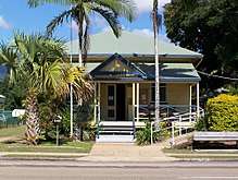
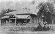
- 53 Victoria Street: Cardwell Post Office (now the Cardwell Bush Telegraph heritage centre)[23]
Cardwell also has a granite monument erected in memory of Walter Jervoise Scott, a pioneer of the Valley of Lagoons. The monument was sent from Great Britain by his brothers intended for his grave at Valley of Lagoons. On arrival at Cardwell, it was found to be too large to transport up the rough track to Valley of Lagoons, so it was erected in Cardwell instead.[24][25]
Population
According to the 2016 census of Population, there were 1,309 people in Cardwell.
- Aboriginal and Torres Strait Islander people made up 8.9% of the population.
- 72.5% of people were born in Australia and 83.0% of people spoke only English at home.
- The most common responses for religion were No Religion 25.6%, Catholic 22.6% and Anglican 20.6%.[1]
Education
Cardwell State School is a government primary (Prep-6) school for boys and girls at 43 Victoria Street (18.2687°S 146.0308°E).[26][27] In 2017, the school had an enrolment of 108 students with 6 teachers (5 full-time equivalent) and 6 non-teaching staff (5 full-time equivalent).[28]
Amenities
The Cassowary Coast Regional Council operates a public library at 4 Balliol Street Cardwell.[29]
Notable residents
- Isidor Lissner, politician
- John Murray, police inspector
- Ashleigh Southern, water polo player
- Margaret Thorsborne, naturalist, conservationist and environmental activist
Christmas Lights hoax
In 2013, the Cardwell community began being the target of an online hoax, which claimed the town's Christmas lights competition had been cancelled to appease the local Muslim community, forcing Cassowary Coast Regional Council to publicly debunk the rumours.[30] Despite this, the hoax continues to circulate on social media.[31]
The hoax originated from an Islamophobic post on the "Meanwhile in Australia" Facebook page, which subsequently went viral. The post detailing the bogus information specifically named the Al Shalalah mosque as the source of the complaint, but such a mosque does not exist in Cardwell.[32]
The information contained within the post was also debunked by fact-checking websites such as snopes.com and Hoax Slayer.[33][34]
Although the original post was deleted, screenshots of the post continue to be shared on social media.[35]
Contrary to the sentiment shared in the fake post, the then Cassowary Coast mayor Bill Shannon said that he had received phone calls from Muslim leaders from as far away as Sydney encouraging Cardwell to continue with their Christmas light displays.[30]
See also
- The Cardwell Bush Telegraph heritage centre, one of the oldest buildings in North Queensland,[36] is located at the southern end of the town.
- Cardwell railway station
References
- Australian Bureau of Statistics (27 June 2017). "Cardwell (State Suburb)". 2016 Census QuickStats. Retrieved 23 January 2018.


- Bureau of Meteorology Archived 31 August 2007 at the Wayback Machine Retrieved 2008-01-27.
- "Cardwell - town (entry 6216)". Queensland Place Names. Queensland Government. Retrieved 26 March 2016.
- "Cardwell - locality (entry 45660)". Queensland Place Names. Queensland Government. Retrieved 26 March 2016.
- "Cardwell decimated by Cyclone Yasi". The Cairns Post. 3 February 2011. Archived from the original on 6 February 2011. Retrieved 3 February 2011.
- (4 February 2011).Weary residents begin cyclone clean-up Archived 7 February 2011 at the Wayback Machine. ABC News. Australian Broadcasting Corporation. Retrieved on 17 April 2012.
- "Port Hinchinbrook resort protest". Green Left Weekly. 1998. Archived from the original on 3 August 2012. Retrieved 7 March 2008.
-

-
- "The New Settlement at Rockingham Bay". Rockhampton Bulletin and Central Queensland Advertiser. 25 August 1864. p. 4. Retrieved 17 April 2012 – via National Library of Australia.
- "The New Settlement At Rockingham Bay". The Empire. Sydney. 11 August 1864. p. 2. Retrieved 17 April 2012 – via National Library of Australia.
- Dalrymple, G.E. (1865). "On the New Settlement at Rockingham Bay". The Journal of the Royal Geographical Society of London. 35: 191–212. JSTOR 3698090.
- "JOURNAL OF AN EXPEDITION TO ROCKINGHAM BAY". Maryborough Chronicle, Wide Bay And Burnett Advertiser. IV (179). Queensland, Australia. 21 April 1864. p. 1 (Maryborough Chronicle, SUPPLEMENT). Retrieved 26 September 2017 – via National Library of Australia.
- Premier Postal History. "Post Office List". Premier Postal Auctions. Retrieved 10 May 2014.
- "ROCKINGHAM BAY". Rockhampton Bulletin And Central Queensland Advertiser (426). Queensland, Australia. 8 April 1865. p. 3. Retrieved 26 September 2017 – via National Library of Australia.
- Moresby, John (1876). New Guinea and Polynesia. Discoveries and Surveys. London: John Murray. Retrieved 20 August 2017.
- "CARDWELL". Queensland Times, Ipswich Herald and General Advertiser. XI (1517). 17 February 1872. p. 3. Retrieved 9 September 2017 – via National Library of Australia.
- "THE BLACKS OF GOULD ISLAND". The Brisbane Courier. XXVI (4, 535). 12 April 1872. p. 3. Retrieved 9 September 2017 – via National Library of Australia.
- Queensland Family History Society (2010), Queensland schools past and present (Version 1.01 ed.), Queensland Family History Society, ISBN 978-1-921171-26-0
- "Public Libraries Statistical Bulletin 2016-17" (PDF). Public Libraries Connect. State Library of Queensland. November 2017. Archived (PDF) from the original on 30 January 2018. Retrieved 31 January 2018.
- "Stone Bridge, Dalrymple Gap Track (entry 600393)". Queensland Heritage Register. Queensland Heritage Council. Retrieved 7 July 2013.
- "Cardwell Divisional Board Hall (former) and Honour Board (entry 601768)". Queensland Heritage Register. Queensland Heritage Council. Retrieved 7 July 2013.
- "Cardwell Post Office – Residence (former) (entry 600392)". Queensland Heritage Register. Queensland Heritage Council. Retrieved 7 July 2013.
- ""CARAVAN TALES."". The Queenslander. 24 April 1930. p. 4. Retrieved 26 March 2014 – via National Library of Australia.
- Bolton, G. C. "Scott, Walter Jervoise (1835–1890)". Australian Dictionary of Biography. National Centre for Biography, Australian National University. Archived from the original on 24 March 2014. Retrieved 25 March 2014.
- "State and non-state school details". Queensland Government. 9 July 2018. Archived from the original on 21 November 2018. Retrieved 21 November 2018.
- "Cardwell State School". Archived from the original on 24 April 2012. Retrieved 21 November 2018.
- "ACARA School Profile 2017". Archived from the original on 22 November 2018. Retrieved 22 November 2018.
- "Cardwell Library". Public Libraries Connect. State Library of Queensland. 19 December 2017. Archived from the original on 31 January 2018. Retrieved 31 January 2018.
- Fernbach, Nathalie; Hession, Pat Hoax won't dim Cardwell's Christmas lights Archived 8 December 2017 at the Wayback Machine, ABC North Queensland, 3 December 2013. Retrieved 2 December 2017.
- Wivell, Danaella Facebook post claims Christmas lights banned in Cairns this year, The Cairns Post, 25 August 2017. Retrieved 2 December 2017.
- Jacques, Owen Christmas lights banned for Muslims? Not in our town Archived 2 December 2017 at the Wayback Machine, The Daily Mercury, 2 December 2013. Retrieved 2 December 2017.
- Christmas lights banned in Cardwell? FALSE, snopes.com. Accessed 2 December 2017.
- Christmas lights were NOT banned in Cardwell Archived 24 September 2017 at the Wayback Machine, Hoax Slayer website. Accessed 2 December 2017.
- Christmas lights ban in Cardwell a hoax Archived 3 December 2017 at the Wayback Machine, Cassowary Coast Regional Council website. Accessed 2 December 2017.
- "Cardwell Post Office – Residence (former)". Australian Heritage Places Inventory. Archived from the original on 29 November 2012. Retrieved 20 April 2012.
External links
| Wikimedia Commons has media related to Cardwell, Queensland. |
| Wikisource has the text of the 1911 Encyclopædia Britannica article Cardwell. |