Mornington Island
Mornington Island is an island in the Gulf of Carpentaria in the Shire of Mornington, Queensland, Australia.[1] It is the northernmost and largest of 22 islands that form the Wellesley Islands group. The largest town Gununa is on the south-west of the island.[2] The Manowar and Rocky Islands Important Bird Area lies about 40 kilometres (25 mi) to the north-west.[3]
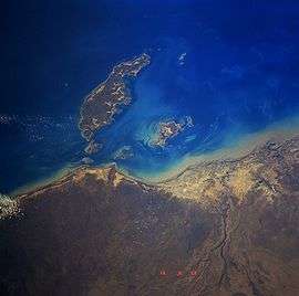 Mornington Island from space, September 1991 | |
 Mornington | |
| Geography | |
|---|---|
| Location | Gulf of Carpentaria |
| Coordinates | |
| Archipelago | Wellesley Islands |
| Total islands | 22 |
| Area | 1,002 km2 (387 sq mi) |
| Highest elevation | 150 m (490 ft) |
| Highest point | unnamed |
| Administration | |
Australia | |
| State | Queensland |
| Local Government Area | Shire of Mornington |
| Largest settlement | Gununa |
| Demographics | |
| Population | 1007 (2001) |
| Pop. density | 1/km2 (3/sq mi) |
| Ethnic groups | Aboriginal |
Description
The general topography of the island is flat with the maximum elevation of 150 metres (490 ft). The island is fringed by mangrove forests and contains 10 estuaries, all in near pristine condition.[4]
The population was estimated to be 1,143 in 2016 [5]and the majority of the citizens live in the township of Gununa. Mornington Island is included in the Shire of Mornington local government area. The majority of the islanders are Aboriginal.
Lardil (or Kunhanaamendaa)[6] are the predominant clan group on Mornington Island and are the traditional owners of the land and surrounding seas. The Kaiadilt clan arrived more recently (1947) from nearby Bentinck Island, when that island's water supply was contaminated by salt after a cyclone. Recent re-building work on aboriginal housing has been undertaken by the James Fraser Foundation, a non-profit organisation in Queensland.
History
Lardil (also known as Gununa, Ladil) is an Australian Aboriginal language spoken on Mornington Island and the Northern Wellesley Islands, within the local government boundaries of the Mornington Shire.[7]
Kuku-Thaypan (also known as Gugu Dhayban, Kuku Taipan, Thaypan) is an Australian Aboriginal language spoken in Hann River, Laura and Musgrave River and on Mornington Island, within the local government boundaries of the Cook Shire.[8]
Macassan trepangers once travelled thousands of kilometres from Sulawesi to Mornington Island and other Australian mainland destinations in search of sea cucumbers. The eastern cape of the island was named Cape Van Diemen after Anthony van Diemen. Commander Matthew Flinders named the island after Richard Wellesley, 1st Marquess Wellesley who was known when younger as the Earl of Mornington.[9]
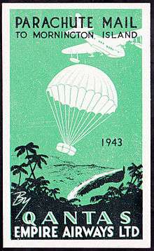
Gununa Post Office opened by 1982.[10]
The Mornington Island Airport was a temporary airfield used by the RAAF and allied air forces during World War II.
Penile subincision is still traditionally performed on the island for those wanting to learn a complex ceremonial language called Damin.
The Mornington Island State School opened on 28 January 1975.[11]
In 1978, the Queensland government decided to take over control of both the Aurukun and Mornington Island Aboriginal reserves.
Cyclones routinely hit the island. In 2000 Cyclone Steve passed directly over the island. Tropical Cyclone May passed in February 1988 and Tropical Cyclone Bernie passed to the west in early 2002. Tropical Cyclone Fritz passed directly over the island on 12 February 2003. Severe Tropical Cyclone Harvey caused damage on the island in February, 2005.
Education
Mornington Island State School offers kindergarten, primary, and limited secondary schooling (K-10) for boys and girls operated by the Queensland Government at 500 Lardil Street. In 2016, the school had an enrolment of 248 students (of which 236 identify as Indigenous) with 29 teachers and 16 non-teaching staff (11 full-time equivalent).[12]
Climate
| Climate data for Mornington Island (1914-present) | |||||||||||||
|---|---|---|---|---|---|---|---|---|---|---|---|---|---|
| Month | Jan | Feb | Mar | Apr | May | Jun | Jul | Aug | Sep | Oct | Nov | Dec | Year |
| Record high °C (°F) | 38.3 (100.9) |
37.6 (99.7) |
37.7 (99.9) |
37.3 (99.1) |
34.9 (94.8) |
33.6 (92.5) |
32.2 (90.0) |
34.5 (94.1) |
38.0 (100.4) |
38.7 (101.7) |
39.0 (102.2) |
39.8 (103.6) |
39.8 (103.6) |
| Average high °C (°F) | 32.2 (90.0) |
31.9 (89.4) |
31.9 (89.4) |
31.4 (88.5) |
28.8 (83.8) |
25.8 (78.4) |
25.7 (78.3) |
27.7 (81.9) |
30.3 (86.5) |
32.3 (90.1) |
33.3 (91.9) |
33.2 (91.8) |
30.4 (86.7) |
| Average low °C (°F) | 25.5 (77.9) |
25.4 (77.7) |
24.6 (76.3) |
23.2 (73.8) |
20.2 (68.4) |
17.1 (62.8) |
16.2 (61.2) |
17.2 (63.0) |
20.6 (69.1) |
23.7 (74.7) |
25.7 (78.3) |
26.2 (79.2) |
22.1 (71.8) |
| Record low °C (°F) | 19.5 (67.1) |
20.0 (68.0) |
19.0 (66.2) |
12.8 (55.0) |
5.5 (41.9) |
7.0 (44.6) |
5.1 (41.2) |
7.2 (45.0) |
11.7 (53.1) |
12.6 (54.7) |
18.5 (65.3) |
20.0 (68.0) |
5.1 (41.2) |
| Average precipitation mm (inches) | 326.8 (12.87) |
307.0 (12.09) |
260.2 (10.24) |
54.0 (2.13) |
9.0 (0.35) |
6.5 (0.26) |
2.3 (0.09) |
0.8 (0.03) |
1.3 (0.05) |
12.7 (0.50) |
55.8 (2.20) |
157.7 (6.21) |
1,198.7 (47.19) |
| Average precipitation days (≥ 0.2 mm) | 15.2 | 14.2 | 12.2 | 4.3 | 1.4 | 0.9 | 0.5 | 0.7 | 0.8 | 1.5 | 4.6 | 9.6 | 65.9 |
| Source: Bureau of Meteorology[13] | |||||||||||||
In literature
Mornington Island was the site of research over several decades by British anthropologist David McKnight, described in a series of books, People, Countries, and the Rainbow Serpent: Systems of classification among the Lardil of Mornington Island (1999), From Hunting to Drinking: The devastating effects of alcohol on an Australian Aboriginal community (2002), Going the Whiteman’s Way: Kinship and marriage among Australian Aborigines (2004) and Of Marriage, Violence and Sorcery: The quest for power in northern Queensland (2005). McKnight lamented the increasing levels of violence since the 1970s.
Indigenous art of Mornington Island is described in The Heart of Everything: The art and artists of Mornington & Bentinck Islands, ed. N. Evans, L. Martin-Chew and P. Memmott (2008).
A tribe of indigenous people on the island have been communicating with wild Indo-Pacific bottlenose dolphins for millennia. It is said that they have "a medicine man who calls the dolphins and 'speaks' to them telepathically. By these communications he assures that the tribes' [sic] fortunes and happiness are maintained."[14][15]
Alcohol Management Plan
In 2003 the Government of Queensland implemented an Alcohol Management Plan to 19 indigenous communities in Queensland where alcohol abuse was rampant.[16] The alcohol bans are aimed at alleviating high levels of domestic violence, child abuse and child neglect. The plan restricts tavern opening hours, limits sales to only light and mid-strength beers, bans takeaway alcohol sales and home brewing.[17] The Mornington Island community has been described as the toughest in Queensland when it comes to resisting alcohol bans.[16]
In December 2003 police reinforcements had to be sent to Mornington Island after riots broke out when tough new alcohol laws were introduced.[16] In 2008 more riots were feared after the Lelka Murrin Hotel, one of only two liquor retailers on the island, closed due to the proprietor being ill. Extra police were sent to the island to stop any unauthorised sale of alcohol and to quash any alcohol-fueled violence that may have erupted at a time when violent incidents on the island were common.[18][19]
As per 2018, alcohol continues to be a major social and health problem. The alcohol ban on the island has led to locals home brewing, which in turn is providing almost unlimited quantities of very cheap alcohol.[20][21]
Location within the Wellesley Islands
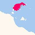 Mornington Island within the Wellesley Islands
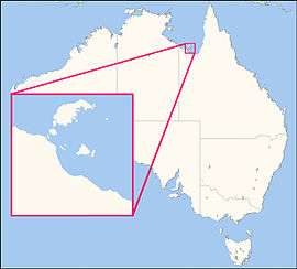 Location of Wellesley Islands in Australia
See also
- List of islands of Australia
- Sydney Island
References
- "Mornington Island - island in the Shire of Mornington (entry 22847)". Queensland Place Names. Queensland Government. Retrieved 29 April 2019.
- "Gununa - population centre in Shire of Mornington (entry 15097)". Queensland Place Names. Queensland Government. Retrieved 9 November 2017.
- BirdLife International. (2011). Important Bird Areas factsheet: Manowar and Rocky Islands. Downloaded from http://www.birdlife.org Archived 30 June 2007 at the Wayback Machine on 11/08/2011.
- "Estuary Assessment 2000: Basin: Mornington Island". Australian Natural Resources Atlas. Department of the Environment, Water, Heritage and the Arts. Archived from the original on 6 October 2009. Retrieved 29 August 2009.
- Australian Bureau of Statistics (2016). "2016 Census QucikStats". Archived from the original on 28 January 2019.
- "Archived copy" (PDF). Archived (PDF) from the original on 11 August 2018. Retrieved 27 May 2017.CS1 maint: archived copy as title (link)
-

-

- "Mornington Shire". Queensland Places. Centre for the Government of Queensland, University of Queensland. Archived from the original on 29 October 2014. Retrieved 29 June 2014.
- Premier Postal History. "Post Office List". Premier Postal Auctions. Retrieved 5 April 2018.
- Queensland Family History Society (2010), Queensland schools past and present (Version 1.01 ed.), Queensland Family History Society, ISBN 978-1-921171-26-0
- "2016 Annual Report" (PDF). Mornington Island State School. Archived from the original (PDF) on 9 November 2017. Retrieved 9 November 2017.
- "Climate Statistics for Mornington Island". Climate statistics for Australian locations. Bureau of Meteorology. Archived from the original on 4 March 2016. Retrieved 6 April 2014.
- Bernd Würsig B.. William Perrin W.. Würsig B.. Thewissen M. G. J.. 2008. Encyclopedia of Marine Mammals 2nd Edition. pp.488. ISBN 9780123735539. Academic Press. Retrieved on March 03, 2017
- "Folklore and Legends (marine mammals)". Archived from the original on 19 May 2016. Retrieved 3 March 2017.
- Ian Townsend (1 December 2003). "Riot on Mornington Island over alcohol bans". PM (ABC Radio). Australian Broadcasting Corporation. Archived from the original on 10 November 2012. Retrieved 31 August 2009.
- Margaret Wenham (28 December 2007). "Eight charged with Christmas rampage". The Courier Mail. Queensland Newspapers. Archived from the original on 28 December 2007. Retrieved 31 August 2009.
- Tanya Chilcott and Steven Wardill (25 January 2008). "Island pub closure sparks riot fear". The Courier Mail. Queensland Newspapers. Retrieved 31 August 2009.
- Gabrielle Dunlevy (24 January 2008). "Brawling forces island pub closure". Brisbane Times. Fairfax Digital. Archived from the original on 25 October 2008. Retrieved 31 August 2009.
- personal observation as a doctor working on the island in 2017 and 2018
- "Mornington Island Homebrew". 7 August 2017. Archived from the original on 18 July 2018.