Bartle Frere, Queensland
Bartle Frere is a locality in the Cairns Region, Queensland, Australia.[2] In the 2016 census, Bartle Frere had a population of 137 people.[1]
| Bartle Frere Queensland | |||||||||||||||
|---|---|---|---|---|---|---|---|---|---|---|---|---|---|---|---|
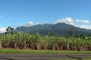 View across the canefields of Bartle Frere with Mount Bartle Frere in the distance, 2014 | |||||||||||||||
 Bartle Frere | |||||||||||||||
| Coordinates | 17°26′22″S 145°53′06″E | ||||||||||||||
| Population | 137 (2016 census)[1] | ||||||||||||||
| • Density | 8.25/km2 (21.38/sq mi) | ||||||||||||||
| Area | 16.6 km2 (6.4 sq mi) | ||||||||||||||
| LGA(s) | Cairns Region | ||||||||||||||
| State electorate(s) | Hill | ||||||||||||||
| Federal Division(s) | Kennedy | ||||||||||||||
| |||||||||||||||
Geography
_and_Bartle_Frere_(background)%2C_2018_02.jpg)
The locality of Bartle Frere lies to the south of Mount Bartle Frere. The locality is flat low-lying land (10–20 metres above sea level) and is freehold land used for farming, predominantly the growing of sugarcane. The Russell River forms the boundary to the locality to the south and east.[3]

The Bruce Highway forms the northern boundary of the locality with the North Coast railway line immediately parallel and adjacent to the north (so just outside the boundary of the locality in neighbouring Eubenangee).[3]
History
The locality takes its name from Mount Bartle Frere, which in turn was named after Sir Henry Bartle Frere, the president of the Royal Geographical Society, by explorer George Elphinstone Dalrymple on 30 September 1873.[2]
Bartle Frere State School opened on 30 January 1922.[4]
In the 2011 census, Bartle Frere had a population of 361 people.[5]
Education
Bartle Frere State School is a co-educational government primary school (P-6) at 29 Price Road. In 2016, the school had an enrolment of 8 students with 2 teachers (1 full-time equivalent) and 4 non-teaching staff (2 full-time equivalent).[6]
References
- Australian Bureau of Statistics (27 June 2017). "Bartle Frere (SSC)". 2016 Census QuickStats. Retrieved 9 May 2018.

- "Bartle Frere - locality (entry 48515)". Queensland Place Names. Queensland Government. Retrieved 3 March 2016.
- "Queensland Globe". State of Queensland. Retrieved 29 July 2017.
- Queensland Family History Society (2010), Queensland schools past and present (Version 1.01 ed.), Queensland Family History Society, ISBN 978-1-921171-26-0
- Australian Bureau of Statistics (31 October 2012). "Bartle Frere". 2011 Census QuickStats. Retrieved 3 March 2016.
- "Annual Report 2016" (PDF). Bartle Frere State School. Archived from the original (PDF) on 29 July 2017. Retrieved 29 July 2017.
Further reading
- Bartle Frere State School (1982), Bartle Frere State School, 1922 1982, diamond jubilee 3rd July, 1982, Bartle Frere State School, Jubilee Committee, retrieved 29 July 2017
External links
![]()