Normanton, Queensland
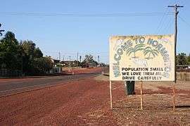
Normanton is a small cattle town and coastal locality in the Shire of Carpentaria in Queensland, Australia.[2][3] In the 2016 census, Normanton had a population of 1,210 people of whom 743 were Indigenous Australians.[1]
| Normanton Queensland | |||||||||||||||
|---|---|---|---|---|---|---|---|---|---|---|---|---|---|---|---|
 Entry into Normanton | |||||||||||||||
 Normanton | |||||||||||||||
| Coordinates | 17°40′0″S 141°04′0″E | ||||||||||||||
| Population | 1,210 (2016 census)[1] | ||||||||||||||
| Established | 1867 | ||||||||||||||
| Postcode(s) | 4890 | ||||||||||||||
| Location | |||||||||||||||
| LGA(s) | Shire of Carpentaria | ||||||||||||||
| State electorate(s) | Traeger | ||||||||||||||
| Federal Division(s) | Kennedy | ||||||||||||||
| |||||||||||||||
| |||||||||||||||
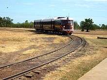
The town is one terminus of the isolated Normanton to Croydon railway line, which was built during gold rush days in the 1890s. The Gulflander motor train operates once a week.
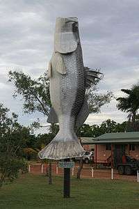
Normanton is the administrative centre of Shire of Carpentaria.[4] Among Normanton's most notable features is a statue[5] of an 8.64 m long saltwater crocodile named Krys, the largest ever taken, which was shot by Krystina Pawlowska in July 1957 in the Norman River.[6] Barramundi and Threadfin Salmon may also be caught in the river.[7] The Big Barramundi, which is 6 m long is also located in the town.[8]
Geography
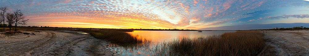
Normanton is in the Gulf Country region of northwest Queensland, just south of the Gulf of Carpentaria, on the Norman River.
An unusual feature 106 km southwest of Normanton is Bang Bang Jump Up, one of the few hills located in the middle of an expansive, flat grassland.[9]
History
The town takes its name from the Norman River, which was named in honour of William Henry Norman of the Victorian Naval Force, who commanded a ship in the search for the explorers Burke and Wills and also conducted hydrographic surveys of the Gulf of Carpentaria and the Torres Strait to identify reefs and other marine hazards.[2]
The site for the town was selected because Burketown was abandoned owing to fever and flooding.[4] Settlers moved into the town in 1867.[10] Normanton attracted people from a variety of cultures, including Chinese drawn to the gold fields.[4]
Norman River Post Office opened on 13 June 1868 and was renamed Normanton by 1872.[11]
The town contains the longest intact and operating Burns Philp store in Queensland. The general mercantile store and agency office was opened in 1884.[12]
The population reached 1,251 by 1891.[13] The gold boom was short-lived. By 1947 the town's population had declined to 234.[13]
In the early years there was a large Aboriginal population as well. Some Aboriginal people were moved to Mornington Island and Doomadgee in the early 20th century.
The Normanton library was opened in 2004.[14]
In 2006 census, the town's population was 1,100, 60 per cent of whom were Indigenous Australians.[15]
Heritage listings
Normanton has a number of heritage-listed sites, including:
- Burke and Wills Access Road (Private Road): Burke and Wills Camp B/CXIX[16]
- Burke Developmental Road: Normanton Cemetery[17]
- 27 Haigh Street: Normanton Gaol[18]
- cnr Landsborough Street and Caroline Street: Burns Philp Building[19]
- Landsborough Street: Westpac Bank Building[20]
- Matilda Street: Normanton railway station[21]
- Normanton to Croydon: Normanton to Croydon railway line[22]
Industry
Like other Gulf communities the prawning industry makes an important economic contribution to the town. Tourism has recently become an important part of the economy of Normanton, with Gulflander a significant draw-card.[13]
Facilities
Normanton has a sports centre, golf course, bowling green, gun club, racecourse, rodeo ground, and an aerodrome. Normanton public library and visitor information services are located in the historic Burns Philp Building at the corner of Caroline and Landsborough Streets.[23][24]
The Normanton branch of the Queensland Country Women's Association has its rooms in Landsborough Street.[25]
Education
Normanton State School opened on 8 September 1882.[26] The school celebrated its centenary in 1982.[27]
Transport
Six kilometres south of the town is the start of the Gulf Developmental Road, part of the Savannah Way tourist drive.
A 151 km remnant of historical railway operates weekly to Croydon. The Normanton railway station features a large steel frame with an open canopy to provide shade.[10]
Climate
Normanton has a tropical savanna climate with two distinct seasons. There is a hot, humid and extremely uncomfortable wet season from December to March and a hot and generally rainless dry season usually extending from April to November. During the wet season most roads in the area are usually closed by heavy rainfall, which on several occasions has exceeded 650 millimetres (26 in) in a month or 250 millimetres (10 in) in a day from tropical cyclones. On occasions, as with all of Queensland, the wet season may fail and deliver as little as 240 millimetres (9.4 in) between December 1934 and March 1935[28]
Temperatures are uniformly hot, ranging from 36.8 °C (98 °F) in November just before the wet season begins to 29 °C (84 °F) at the height of the dry season in July. In the wet season, temperatures are marginally lower, but extremely high humidity means conditions are very uncomfortable and wet bulb temperatures averages 25 °C (77 °F) and can reach 28 °C (82 °F). In the dry season, lower humidity, cloudless days and cool nights provides for more pleasant conditions.
| Climate data for Normanton Post Office, Queensland | |||||||||||||
|---|---|---|---|---|---|---|---|---|---|---|---|---|---|
| Month | Jan | Feb | Mar | Apr | May | Jun | Jul | Aug | Sep | Oct | Nov | Dec | Year |
| Record high °C (°F) | 43.1 (109.6) |
41.0 (105.8) |
40.1 (104.2) |
39.5 (103.1) |
37.2 (99.0) |
35.6 (96.1) |
35.6 (96.1) |
38.3 (100.9) |
40.1 (104.2) |
41.8 (107.2) |
43.3 (109.9) |
43.3 (109.9) |
43.3 (109.9) |
| Average high °C (°F) | 34.7 (94.5) |
33.9 (93.0) |
34.2 (93.6) |
34.0 (93.2) |
31.7 (89.1) |
29.2 (84.6) |
29.1 (84.4) |
31.1 (88.0) |
33.9 (93.0) |
35.9 (96.6) |
36.8 (98.2) |
36.1 (97.0) |
33.4 (92.1) |
| Average low °C (°F) | 25.1 (77.2) |
24.9 (76.8) |
24.4 (75.9) |
22.4 (72.3) |
19.1 (66.4) |
16.1 (61.0) |
15.2 (59.4) |
16.5 (61.7) |
19.5 (67.1) |
22.6 (72.7) |
24.7 (76.5) |
25.3 (77.5) |
21.3 (70.3) |
| Record low °C (°F) | 18.3 (64.9) |
17.3 (63.1) |
16.7 (62.1) |
14.4 (57.9) |
7.2 (45.0) |
6.7 (44.1) |
7.0 (44.6) |
6.6 (43.9) |
11.1 (52.0) |
13.7 (56.7) |
15.5 (59.9) |
18.9 (66.0) |
6.6 (43.9) |
| Average rainfall mm (inches) | 260.2 (10.24) |
249.2 (9.81) |
157.7 (6.21) |
30.9 (1.22) |
7.5 (0.30) |
9.2 (0.36) |
3.2 (0.13) |
1.7 (0.07) |
3.0 (0.12) |
10.5 (0.41) |
45.1 (1.78) |
144.4 (5.69) |
922.6 (36.34) |
| Average rainy days (≥ 0.2 mm) | 13.9 | 13.9 | 9.4 | 2.4 | 0.9 | 0.7 | 0.5 | 0.3 | 0.4 | 1.3 | 4.4 | 9.0 | 57.1 |
| Average relative humidity (%) | 74 | 78 | 70 | 57 | 52 | 52 | 48 | 44 | 45 | 49 | 54 | 65 | 57 |
| Source: [29] | |||||||||||||
See also
References
- Australian Bureau of Statistics (27 June 2017). "Normanton (UCL)". 2016 Census QuickStats. Retrieved 15 November 2017.

- "Normanton - town (entry 43962)". Queensland Place Names. Queensland Government. Retrieved 5 July 2016.
- "Normanton - locality (entry 44655)". Queensland Place Names. Queensland Government. Retrieved 5 July 2016.
- Environmental Protection Agency (Queensland) (2002). Heritage Trails of the Queensland Outback. State of Queensland. p. 94. ISBN 0-7345-1040-3.
- "Image: 1.1318938577.krys-the-savannah-king.jpg, (550 × 413 px)". Photograph taken from 27°28′3.36″S 153°1′40.8″E: images.travelpod.com. 3 October 2007. Archived from the original on 21 December 2015. Retrieved 4 September 2015.CS1 maint: location (link)
- "Death of a monster | The Australian". theaustralian.com.au. 25 November 2008. Archived from the original on 24 April 2013. Retrieved 4 September 2015.
- Groover, Gavin (31 January 2017). "Carpentaria Barra and Sport Fishing Charters". Carpentaria Barra and Sport Fishing Charters. Archived from the original on 2 February 2017. Retrieved 30 January 2017.
- "Big Barramundi". The Courier-Mail. News Queensland. Archived from the original on 24 March 2012. Retrieved 11 December 2012.
- "Normanton > Attractions". Explore Australia Publishing. Archived from the original on 11 July 2017. Retrieved 13 June 2017.
- Cook, Penny (2006). Discover Queensland Heritage. Corinda, Queensland: Pictorial Press Australia. p. 18. ISBN 1876561424.
- Premier Postal History. "Post Office List". Premier Postal Auctions. Retrieved 10 May 2014.
- Brian Williams (24 October 2011). "Queensland's earliest surviving Burns Philp store at Normanton, Gulf of Carpentaria, to be heritage-listed". The Courier Mail. News Queensland. Retrieved 11 December 2012.
- "Travel: Normanton". Sydney Morning Herald. Fairfax Media. 8 February 2004. Archived from the original on 31 May 2014. Retrieved 11 December 2012.
- "Public Libraries Statistical Bulletin 2016-17" (PDF). Public Libraries Connect. State Library of Queensland. November 2017. p. 12. Archived (PDF) from the original on 30 January 2018. Retrieved 15 January 2018.
- Australian Bureau of Statistics (25 October 2007). "Normanton (Urban Centre/Locality)". 2006 Census QuickStats. Retrieved 3 May 2009.
- "Burke and Wills' Camp B/CXIX and Walker's Camp, Little Bynoe River (entry 602156)". Queensland Heritage Register. Queensland Heritage Council. Retrieved 7 July 2013.
- "Normanton Cemetery (entry 601157)". Queensland Heritage Register. Queensland Heritage Council. Retrieved 7 July 2013.
- "Normanton Gaol (entry 601501)". Queensland Heritage Register. Queensland Heritage Council. Retrieved 7 July 2013.
- "Burns Philp Building (former) (entry 602781)". Queensland Heritage Register. Queensland Heritage Council. Retrieved 7 July 2013.
- "Westpac Bank, Normanton (entry 600394)". Queensland Heritage Register. Queensland Heritage Council. Retrieved 7 July 2013.
- "Normanton Railway Terminus (entry 600395)". Queensland Heritage Register. Queensland Heritage Council. Retrieved 7 July 2013.
- "Normanton to Croydon Railway Line (entry 600396)". Queensland Heritage Register. Queensland Heritage Council. Retrieved 7 July 2013.
- "Normanton". Centre for the Government of Queensland. Archived from the original on 5 March 2011. Retrieved 17 January 2011.
- "Visitor Information Centres and Libraries". Carpentaria Shire Council. Archived from the original on 15 January 2018. Retrieved 15 January 2018.
- "Branch locations". Queensland Country Women's Association. Archived from the original on 26 December 2018. Retrieved 26 December 2018.
- "Opening and closing dates of Queensland Schools". Queensland Government. Retrieved 18 April 2019.
- O'Neill, Brian W; Normanton State School, A unique school in the Gulf : a study of the influence of the pastoral and mining industries on education in the Gulf, with particular reference to Normanton / compiled by Brian W. O'Neill, W.J. & J.M. O'Neill
- "Monthly Rainfall - 029041 - Bureau of Meteorology | Normanton Post Office". bom.gov.au. Retrieved 4 September 2015.
- "Climate statistics for Australian locations – Normanton Post Office (1872–2001)". bom.gov.au. Archived from the original on 23 September 2015. Retrieved 4 September 2015.