Herberton, Queensland
Herberton is a rural town and locality in the Tablelands Region, Queensland, Australia.[2][3] In the 2016 census, Herberton had a population of 855 people.[1]
| Herberton Queensland | |||||||||||||||
|---|---|---|---|---|---|---|---|---|---|---|---|---|---|---|---|
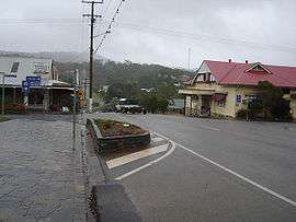 The main street of Herberton | |||||||||||||||
 Herberton | |||||||||||||||
| Coordinates | 17.3813°S 145.3838°E | ||||||||||||||
| Population | 855 (2016 census)[1] | ||||||||||||||
| • Density | 36.70/km2 (95.04/sq mi) | ||||||||||||||
| Established | 1880 | ||||||||||||||
| Postcode(s) | 4887 | ||||||||||||||
| Elevation | 918 m (3,012 ft) | ||||||||||||||
| Area | 23.3 km2 (9.0 sq mi) | ||||||||||||||
| Time zone | AEST (UTC+10:00) | ||||||||||||||
| LGA(s) | Tablelands Region | ||||||||||||||
| State electorate(s) | Hill | ||||||||||||||
| Federal Division(s) | Kennedy | ||||||||||||||
| |||||||||||||||
| |||||||||||||||
At its apogee, Herberton was the richest tin mining field in Australia, and was home to 17 public hotels, 2 local newspapers and a brewery.
Geography and climate
Herberton is on the Atherton Tableland in Far North Queensland. It is situated 918 metres (3,012 ft) high on the Great Dividing Range south-west of Atherton. Vegetation ranges from tropical rainforest to the east, wet sclerophyll forests to the north and east and open sclerophyll forests and woodlands to the north and west.
History
The first European exploration of this area, part of the traditional land of the Dyirbal, was undertaken in 1875 by James Venture Mulligan. Mulligan was prospecting for gold, but instead found tin. The town of Herberton was established on 19 April 1880 by John Newell to exploit the tin find, and mining began on 9 May 1880. By September 1880, Herberton had a population of 300 men and 27 women. Herberton Post Office opened on 22 November 1880.[4]
The town's name is attributed to John Newell. It is believed he named it after the Herbert River whose northern tributary (Wild River) flows through Herberton and/or after Robert George Wyndham Herbert, the first Premier of Queensland (after whom the Herbert River is named).[2]
In July 1881 the residents of Herberton had raised £115 for the construction of a school. Herberton Provisional School opened on 12 December 1881 with 35 students in the Herberton Hall; the fee was one shilling per week for the first child of a family with an additional sixpence a week for each additional child.[5][6] In October 1882 the Queensland Government reserved five acres and two roods for a state school and called for tenders to erect a state school and teacher's residence.[7][8] In November 1882 the contract for the buildings was awarded to James Pasley to construct the buildings using hardwood in nine months for £2,040.[9] In April 1883 the Queensland Government officially announced that there would be a new state school in Herberton.[10] The actual opening date of the new state school is unclear but Thomas Peter Wood was appointed headmaster of Herberton State School from 1 January 1884, so the school was operational at that time.[11] In 1912 the school was one of the first five schools in Queensland to receive a secondary department, commencing operations on 15 February 1912 with the arrival of the teacher Miss Ramsay B.A. who would teach two languages, English history, mathematics, and science.[12] In 1994 a new primary school campus was established with the secondary department remaining on the original school site.[13]
In January 1882 the Queensland Government called for tenders to construct a telegraph line to Herberton.[14] In March 1882 they called for tenders for a post and telegraph office.[15]
In the late 19th century the Mulligan Highway was carved through the hills from Herberton and passed through what is now Main Street, Atherton, before continuing down to Port Douglas. This road was used by the coaches of Cobb and Co to access Western Queensland.
The tin mining in Herberton motivated the Queensland Government to build a railway line to connect Herberton to a coastal port. Three ports were considered: Port Douglas, Cairns and Geraldton (now Innisfail), all involving a crossing of the Great Dividing Range. The route from Innisfail was shortest but would go through the roughest terrain crossing the Great Dividing Range. The route from Port Douglas was the easiest to build but it would be longest. Eventually Cairns was chosen as it had the best port (and the unstable geology of the proposed Barron Gorge route was not known at that time) and the first section of the Tablelands railway from Cairns to Redlynch at the base of the range was opened on 8 October 1887. However, the railway to Herberton was not completed until 20 October 1910 by which time the tin mining boom was over.[16]
St Mary's Anglican School for girls was opened in 1918 by the Sisters of the Sacred Advent.[17] The school closed in 1965.[5]
Mount St Bernard College was established on 1 February 1921 by the Sisters of Mercy.[5]
Tin mining ceased in Herberton in 1985.
The Herberton Public Library opened in 1995 with a major refurbishment in 2016.[18]
At the 2006 census, Herberton had a population of 974.[19]
In the 2011 census, Herberton had a population of 934 people.[20]
Heritage listings
Herberton has a number of heritage-listed sites, including:
- 38 Broadway Street: Holy Trinity Anglican Church[21]
- Grace Street: Jack & Newell General Store[22]
- 61 Grace Street: Herberton School of Arts[23]
- off Jacks Road: Great Northern Mine[24]
- 2-4 Lillian Street: Herberton Uniting Church[25]
- Myers Street: Herberton War Memorial[26]
Climate
Herberton is notably drier than the area around Atherton with average rainfall for Herberton of 1,154.6 mm (45.46 in).[27] Herberton is the most northerly location in Australia to have recorded a temperature at or below −5 °C (23 °F), and also the only location in Tropical North Queensland to have done so. The average minimum temperature ranges from 10 °C (50 °F) in winter to 18 °C (64 °F) in summer, while maximums range from 21 to 29 °C (70 to 84 °F).
| Climate data for Herberton | |||||||||||||
|---|---|---|---|---|---|---|---|---|---|---|---|---|---|
| Month | Jan | Feb | Mar | Apr | May | Jun | Jul | Aug | Sep | Oct | Nov | Dec | Year |
| Record high °C (°F) | 35.2 (95.4) |
35.2 (95.4) |
32.8 (91.0) |
33.0 (91.4) |
30.6 (87.1) |
31.1 (88.0) |
28.3 (82.9) |
31.7 (89.1) |
33.3 (91.9) |
35.7 (96.3) |
38.1 (100.6) |
36.7 (98.1) |
38.1 (100.6) |
| Average high °C (°F) | 28.0 (82.4) |
27.3 (81.1) |
26.3 (79.3) |
24.6 (76.3) |
22.9 (73.2) |
21.5 (70.7) |
21.4 (70.5) |
22.7 (72.9) |
24.9 (76.8) |
27.5 (81.5) |
28.6 (83.5) |
28.9 (84.0) |
25.4 (77.7) |
| Average low °C (°F) | 18.2 (64.8) |
18.3 (64.9) |
17.5 (63.5) |
15.6 (60.1) |
13.2 (55.8) |
10.6 (51.1) |
9.7 (49.5) |
10.1 (50.2) |
12.0 (53.6) |
14.3 (57.7) |
16.2 (61.2) |
17.5 (63.5) |
14.4 (57.9) |
| Record low °C (°F) | 9.5 (49.1) |
10.2 (50.4) |
8.9 (48.0) |
7.2 (45.0) |
−1.1 (30.0) |
−3.3 (26.1) |
−5.0 (23.0) |
−2.2 (28.0) |
0.6 (33.1) |
3.4 (38.1) |
8.3 (46.9) |
9.4 (48.9) |
−5.0 (23.0) |
| Average rainfall mm (inches) | 239.2 (9.42) |
234.7 (9.24) |
211.3 (8.32) |
84.4 (3.32) |
46.2 (1.82) |
33.7 (1.33) |
22.3 (0.88) |
17.7 (0.70) |
16.3 (0.64) |
26.5 (1.04) |
79.6 (3.13) |
138.5 (5.45) |
1,150.4 (45.29) |
| Average rainy days (≥ 0.2 mm) | 16.4 | 16.5 | 16.4 | 13.7 | 11.9 | 8.6 | 7.0 | 5.4 | 4.7 | 5.1 | 8.3 | 11.6 | 125.6 |
| Source: Bureau of Meteorology[27] | |||||||||||||
Industries
Several crops are grown around Herberton, and it is the location of Queensland's only tropical vineyard. Herberton is a mini salad bowl with crops including avocados, lettuce, tomatoes, maize and pumpkins. Poultry and beef industries are also present.
Herberton's public hospital and the private school, Mt Saint Bernard residential college, are other major employers in the town.
Tourism and attractions

The Herberton Mining Museum and Visitor Information Centre opened in 2005, houses mining and social history of the Herberton Mining field, archives for the local area and maintains a genealogy project recording the families of the district and their histories.[28]
A Heritage Walk for tourists that takes in some of the old buildings and historical features of the town is a popular attraction. Historic Village Herberton is a 16-acre representation of a mining town filled with streets of buildings of the time, each one a museum in its own right with exhibits such as vintage machinery, cars and Australian antiques. It has more than 50 restored period buildings.[29]
The Herberton Spy & Camera Museum houses antique spy cameras, a photographic gallery and photographic memorabilia with guided tours through the museum and a working photographer and photographic studio.
Most recently, a railway museum has been established by volunteers in the former Herberton railway station building. This is operated by volunteers and only open part-time.
The Tepon Equestrian Grounds[30] just out of Herberton have recently been upgraded with a large undercover pavilion for equestrian and other sporting events such as cycling and mountain biking. Local markets are held on the 3rd Sunday of every month at the Wondecla Oval.
There are several caravan parks, hotels, motels and B&Bs located in the town.
Amenities
The Tablelands Regional Council operates a Herberton Public Library and Customer Service Centre at 61 Grace Street.[31]
The Herberton branch of the Queensland Country Women's Association meets at the QCWA Hall at 14 William Street.[32]
Education
Herberton State School is a government primary and secondary (Prep-10) school for boys and girls at Elwyn Phillips Memorial Drive in Moomin (17.3723°S 145.3790°E).[33][34] In 2017, the school had an enrolment of 176 students with 20 teachers (17 full-time equivalent) and 17 non-teaching staff (12 full-time equivalent).[35] It inclludes a special education program.[33] The new primary school campus constructed in 1994 is not within Herberton but within the neighbouring locality of Moomin. However, the secondary (7-10) campus is at the original school site in Grace Street, Herberton (17.3805°S 145.3825°E).[33][36]
Mount St Bernard College is a Catholic secondary (7-12) school for boys and girls at 15 Broadway Street (17.3793°S 145.3826°E).[33][37] In 2017, the school had an enrolment of 191 students with 34 teachers (32 full-time equivalent) and 31 non-teaching staff (26 full-time equivalent).[38]
Notable people
Notable people associated with Herberton include:
- Bunny Adair, Member of the Queensland Legislative Assembly for Cook who attended Herberton State School.
- Alice Bonar, founder of the Australian Red Cross in Herberton, now the oldest continuously operating branch in Australia. In 1914 reconvened the branch as a member of the Australian Red Cross. Eldest son David Welbourn Bonar a tunneller at Hill 60 and daughter May was a nurse in World War 1.[39]
- Nancy Francis, journalist and poet known as 'Black Bonnet'. Wrote extensively on life in the Daintree area including recording indigenous culture. Wrote poetry published in North Queensland papers and The Bulletin.
- James Douglas Henry, mining engineer, served in 4th Queensland Imperial Bushmen contingent. Member of the Mining Corps then Commanding Officer of 1st Australian Tunnellers involved in Hill 60. Retired to Tepon near Herberton and ARP warden for Wondecla area in World War 2.[40]
- John Ledlie, one of the founders of North Queensland firm Armstrong, Ledlie and Stillman. Brought the first electric street lights outside his Herberton store. Shire Chairman of Herberton Shire Council, member of Cairns Harbour Board and Cairns Regional Electricity Board. Teamed with Robert Ringrose to establish Herberton State High School in 1912.
- John Newell, Member of the Queensland Legislative Assembly for Woothakata , Chairman of Herberton Shire Council, Mayor of Herberton Municipality. One of the discoverers of payable tin and the establishment of Herberton Gold and Mineral Field. Founding member of the Tinaroo Division Board.
- Robert Ringrose, barrister, geologist, naturalist, fellow of Royal Geographical Society of Queensland who established the conservation area now known as Mount Hypipamee National Park. Worked to establish the Charters Towers School of Mines and one of the first 12 state high schools in Herberton in 1912.
- Tom Risley, artist and sculptor. Trained as an electrician then worked in rainforest ecology in CSIRO. His work is held in New York Museum of Modern Art, gallery in Japan, pieces in National Gallery of Australia and Queensland Art Gallery, private collections and one of his largest sculptures is situated in the Gordon Gardens in the Herberton Mining Museum & Visitor Information Centre.
References
- Australian Bureau of Statistics (27 June 2017). "Herberton (SSC)". 2016 Census QuickStats. Retrieved 20 October 2018.

- "Herberton - town in Tablelands Region (entry 15767)". Queensland Place Names. Queensland Government. Retrieved 17 November 2019.
- "Herberton - locality in Tablelands Region (entry 48668)". Queensland Place Names. Queensland Government. Retrieved 17 November 2019.
- Premier Postal History. "Post Office List". Premier Postal Auctions. Retrieved 10 May 2014.
- Queensland Family History Society (2010), Queensland schools past and present (Version 1.01 ed.), Queensland Family History Society, ISBN 978-1-921171-26-0
- "HERBERTON". The Telegraph (2, 890). Queensland, Australia. 28 December 1881. p. 5. Retrieved 30 November 2019 – via National Library of Australia.
- "OFFICIAL NOTIFICATIONS". The Brisbane Courier. XXXVII (7, 719). Queensland, Australia. 7 October 1882. p. 6. Retrieved 30 November 2019 – via National Library of Australia.
- "OFFICIAL NOTIFICATIONS". The Brisbane Courier. XXXVII (7, 731). Queensland, Australia. 21 October 1882. p. 3. Retrieved 30 November 2019 – via National Library of Australia.
- "The Brisbane Courier". The Brisbane Courier. XXXVII (7, 749). Queensland, Australia. 11 November 1882. p. 5. Retrieved 30 November 2019 – via National Library of Australia.
- "OFFICIAL NOTIFICATIONS". The Telegraph (3, 283). Queensland, Australia. 21 April 1883. p. 5. Retrieved 30 November 2019 – via National Library of Australia.
- "OFFICIAL NOTIFICATIONS". The Brisbane Courier. XXXVIII (8, 114). Queensland, Australia. 12 January 1884. p. 6. Retrieved 30 November 2019 – via National Library of Australia.
- "HERBERTON HIGH SCHOOL". Cairns Post. XXVI (1243). Queensland, Australia. 24 February 1912. p. 4. Retrieved 30 November 2019 – via National Library of Australia.
- "History". Herberton State School. 22 July 2013. Retrieved 29 November 2019.
- "Official Notifications". The Brisbane Courier. XXXVI (7, 497). Queensland, Australia. 21 January 1882. p. 6. Retrieved 30 November 2019 – via National Library of Australia.
- "OFFICIAL NOTIFICATIONS". The Brisbane Courier. XXXVI (7, 545). Queensland, Australia. 18 March 1882. p. 5. Retrieved 30 November 2019 – via National Library of Australia.
- Kerr, John (1990). Triumph of narrow gauge : a history of Queensland Railways. Boolarong Publications. pp. 52, 224. ISBN 978-0-86439-102-5.
- "ST. MARY'S CHURCH OF ENGLAND". Cairns Post. XXXI (2981). Queensland, Australia. 15 February 1918. p. 6. Retrieved 20 November 2019 – via National Library of Australia.
- "Queensland Public Library Statistical Bulletin 2016-17" (PDF). Public Libraries Connect. November 2017. Archived (PDF) from the original on 30 January 2018. Retrieved 15 January 2018.
- Australian Bureau of Statistics (25 October 2007). "Herberton (L) (Urban Centre/Locality)". 2006 Census QuickStats. Retrieved 24 May 2011.
- Australian Bureau of Statistics (31 October 2012). "Herberton (SSC)". 2011 Census QuickStats. Retrieved 7 June 2016.
- "Holy Trinity Anglican Church (entry 600538)". Queensland Heritage Register. Queensland Heritage Council. Retrieved 14 July 2013.
- "Jack & Newell General Store & Petrol Bowser (former) (entry 600539)". Queensland Heritage Register. Queensland Heritage Council. Retrieved 14 July 2013.
- "Herberton School of Arts (entry 600540)". Queensland Heritage Register. Queensland Heritage Council. Retrieved 14 July 2013.
- "Great Northern Mine (Herberton) (entry 600542)". Queensland Heritage Register. Queensland Heritage Council. Retrieved 14 July 2013.
- "Herberton Uniting Church (entry 601788)". Queensland Heritage Register. Queensland Heritage Council. Retrieved 14 July 2013.
- "Herberton War Memorial (entry 600541)". Queensland Heritage Register. Queensland Heritage Council. Retrieved 14 July 2013.
- "HERBERTON MOWBRAY RD". Climate statistics for Australian locations. Bureau of Meteorology. November 2015. Retrieved 20 January 2020.
- "Mining Museum - Herberton". Archived from the original on 25 January 2014. Retrieved 7 June 2016.
- "Historic Village, Herberton". Herberton Historic Village. Archived from the original on 25 September 2013. Retrieved 2 February 2014.
- "Tepon Equestrian Park". Archived from the original on 13 March 2016. Retrieved 7 June 2016.
- "Herberton Public Library". Public Libraries Connect. Archived from the original on 15 January 2018. Retrieved 15 January 2018.
- "Branch Locations". Queensland Country Women's Association. Archived from the original on 26 December 2018. Retrieved 26 December 2018.
- "State and non-state school details". Queensland Government. 9 July 2018. Archived from the original on 21 November 2018. Retrieved 21 November 2018.
- "Herberton State School". Retrieved 21 November 2018.
- "ACARA School Profile 2017". Archived from the original on 22 November 2018. Retrieved 22 November 2018.
- "Herberton State School - Secondary Campus". Retrieved 21 November 2018.
- "Mount St Bernard College". Retrieved 21 November 2018.
- "ACARA School Profile 2017". Archived from the original on 22 November 2018. Retrieved 22 November 2018.
- 2001 Australian Red Cross. p. 16.
- "MAJOR JAMES DOUGLAS HENRY D.S.O. O.B.E." Tunnellers Research Website. Archived from the original on 14 May 2018. Retrieved 14 May 2018.
External links
| Wikimedia Commons has media related to Herberton, Queensland. |
- "Herberton". Queensland Places. Centre for the Government of Queensland, University of Queensland.
- Town map of Herberton, 1980
- Herberton Historic Village