Laura, Queensland
Laura is a small town and locality in Cook Shire, Cape York Peninsula in northern Queensland, Australia.[2][3] It is on the only road north towards the tip of the peninsula, and is the centre for the largest collection of prehistoric rock art in the world. It also forms the northern apex of the "Scenic Triangle" between Cooktown, Lakeland, and Laura.
| Laura Queensland | |||||||||||||||
|---|---|---|---|---|---|---|---|---|---|---|---|---|---|---|---|
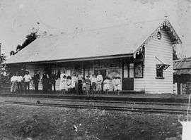 Laura Railway Station in 1896 | |||||||||||||||
 Laura | |||||||||||||||
| Coordinates | 15°33′31″S 144°26′45″E | ||||||||||||||
| Population | 80 (2011 census)[1] | ||||||||||||||
| Postcode(s) | 4871 | ||||||||||||||
| Location | |||||||||||||||
| LGA(s) | Shire of Cook | ||||||||||||||
| State electorate(s) | Cook | ||||||||||||||
| Federal Division(s) | Leichhardt | ||||||||||||||
| |||||||||||||||
Some of the world's most extensive and ancient rock painting galleries surround the tiny town of Laura, some of which are available for public viewing. Laura has an Interpretive Centre from which information on the rock art and local Aboriginal culture is available and tours can be arranged.
Laura is only a few kilometres from the southern entrance to Lakefield National Park.
History
Aboriginal people have made their home in the Laura River valley for at least 50,000 years. In the wet season, they would camp under rock shelters on the high ground. This is where their rock art can be found. The area was on the borders of Kokowara and Kokojawa lands.
Guugu Yimithirr (also known as Koko Yindjir, Gugu Yimidhirr, Guguyimidjir) is an Australian Aboriginal language of Hope Vale and the Cooktown area. The language region includes the local government area of the Aboriginal Shire of Hope Vale and the Shire of Cook, particularly the localities of Cape Bedford, Battle Camp (in Laura) and sections of the Normanby River and Annan River.[4]
Kuku-Thaypan (also known as Gugu Dhayban, Kuku Taipan, Thaypan) is an Australian Aboriginal language spoken in Hann River, Laura and Musgrave River and on Mornington Island, within the local government boundaries of the Cook Shire.[5]
Some of the earliest pastoral leases on Cape York Peninsula were taken up in the Laura district. However, the town of Laura did not develop until the discovery of gold on the Palmer River.
The town takes its name from the Laura River, which in turn was named in 1873 by explorer and surveyor Archibald Campbell Macmillan after his wife Laura Bower (née Poingdestre).[2]
In 1873 gold was discovered on the Palmer River. Travellers coming from Cooktown to the Palmer Goldfields would cross the Laura River at Laura. This was a very violent period, as local aboriginal clans waged a war of resistance against encroachment on and usurpation of their lands.[6] A Native Mounted Police camp was established near the Lower Laura crossing to protect travellers.[7]
During the gold boom a railway line was planned between Cooktown and the Palmer gold fields. By 1888 the line had been built to Laura.
Laura Post Office opened on 8 October 1888.[8]
Laura State School opened in March 1889 and currently caters for students from Prep to Year six.[9][10]
An impressive bridge over the Laura River was opened, to great fanfare, in 1891. However, since the Palmer gold fields were in decline, a new Queensland government decided to abandon the project. Only one train ever crossed the bridge - the train that ran on the day that it opened.
The rail line contributed to the growth of Laura. It was used by miners and by peninsula cattle properties. The Cooktown to Laura Railway finally closed in 1961.
It was during the 1960s that Quinkan rock art galleries were reported by Percy Trezise, an airline pilot who surveyed the area from the air for likely sites and later walked in to rediscover them.
At the 2006 census, Laura and the surrounding area had a population of 225.[11]
In the 2011 census, Laura had a population of 80 people.[1]
Heritage listings
Laura has a number of heritage-listed sites, including:
- Laura to Maytown: Laura to Maytown Coach Road[12]
References
- Australian Bureau of Statistics (31 October 2012). "Laura". 2011 Census QuickStats. Retrieved 1 June 2016.

- "Laura - town (entry 19042)". Queensland Place Names. Queensland Government. Retrieved 1 June 2016.
- "Laura - locality (entry 46132)". Queensland Place Names. Queensland Government. Retrieved 1 June 2016.
-

-

- Noelene Cole, 'Battle Camp to Boralga: a local study of colonial war on Cape York Peninsula, 1873-1894,' Archived 8 January 2018 at the Wayback Machine Aboriginal History 2004, Vol. 28, pp 156–189.
- Cole, 2004 p.171:'Native Mounted Police detachments could be commissioned as escorts or to protect travellers 'who had a reasonable claim'. However, the core duty was to conduct 'bush patrols' to contain Aborigines. These forays were often in response to settler complaints of 'depredations' in which case Aborigines were vigorously pursued, sometimes over long distances, and 'dispersed', ie shot.'
- Premier Postal History. "Post Office List". Premier Postal Auctions. Retrieved 10 May 2014.
- "Laura SS". Archived from the original on 4 February 2017. Retrieved 1 February 2017.
- "Opening and closing dates of Queensland Schools". Queensland Government. Retrieved 18 April 2019.
- Australian Bureau of Statistics (25 October 2007). "Laura (Cook Shire) (State Suburb)". 2006 Census QuickStats. Retrieved 5 July 2008.
- "Laura to Maytown Coach Road (entry 600427)". Queensland Heritage Register. Queensland Heritage Council. Retrieved 7 July 2013.
Further reading
- Pike, Glenville. 1979. Queen of the North: A Pictorial History of Cooktown and Cape York Peninsula. G. Pike. ISBN 0-9598960-5-8.
- Trezise, P.J. 1969. Quinkan Country: Adventures in Search of Aboriginal Cave Paintings in Cape York. A.H. & A.W. Reed, Sydney.
- Trezise, P.J. 1993. Dream Road: A Journey of Discovery. Allen & Unwin, St. Leonards, Sydney.
- Premier's Department (prepared by Connell Wagner). 1989. Cape York Peninsula Resource Analysis. Cairns. (1989). ISBN 0-7242-7008-6
- Roth, W.E. 1897. The Queensland Aborigines. 3 Vols. Reprint: Facsimile Edition, Hesperian Press, Victoria Park, W.A., 1984. ISBN 0-85905-054-8
- Ryan, Michelle and Burwell, Colin, eds. 2000. Wildlife of Tropical North Queensland: Cooktown to Mackay. Queensland Museum, Brisbane. ISBN 0-85905-045-9 (set of 3 vols).
- Scarth-Johnson, Vera. 2000. National Treasures: Flowering plants of Cooktown and Northern Australia. Vera Scarth-Johnson Gallery Association, Cooktown. ISBN 0-646-39726-5 (pbk); ISBN 0-646-39725-7 Limited Edition - Leather Bound.
- Sutton, Peter (ed). Languages of Cape York: Papers presented to a Symposium organised by the Australian Institute of Aboriginal Studies. Australian Institute of Aboriginal Studies, Canberra. (1976). ISBN 0-85575-046-4
- Wynter, Jo and Hill, John. 1991. Cape York Peninsula: Pathways to Community Economic Development. The Final Report of The Community Economic Development Projects Cook Shire. Cook Shire Council.
- Laura: A shared history of a river and a town. Cook Shire pamphlet.
External links
| Wikimedia Commons has media related to Laura, Queensland. |
| Authority control |
|
|---|