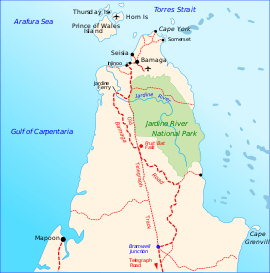
Jardine River National Park
The Jardine River National Park is a national park in Queensland, Australia, 2,137 km northwest of Brisbane and about 900 km northwest of Cairns, on the tip of Cape York Peninsula.[1]
| Jardine River National Park Queensland | |
|---|---|
IUCN category II (national park) | |
 Jardine River National Park | |
| Nearest town or city | Weipa |
| Established | 16 December 1994 |
| Area | 2,370 km2 (915.1 sq mi) |
| Managing authorities | Queensland Parks and Wildlife Service |
| Website | Jardine River National Park |
| See also | Protected areas of Queensland |
The park and reserves encompass the traditional country of several Aboriginal groups including people from the Atambaya, Angkamuthi, Yadhaykenu, Gudang and Wuthathi language and social groups. The area is a living cultural landscape, with places and features named in Aboriginal languages, story-places and story-beings, and occupation and ceremony sites throughout. Today the traditional owners retain a strong and continuing interest, through their traditional rights to, and responsibilities for, the land, in the protection and management of the area.[2]
Waterfalls
The park contains several waterfalls and rock pools, including Twin Falls, where the waters of Elliot River and Canal Creek meet, Fruit Bat Falls, Savo Falls and Elliot (Indian Head) Falls.
Gallery
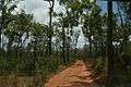 Jardine River National Park
See also
References
- Hema, Maps (2007). Australia Road and 4WD Atlas (Map). Eight Mile Plains Queensland: Hema Maps. p. 104. ISBN 978-1-86500-456-3.
- Qld. Govt. Department of National Parks - Jardine River