Mission Beach, Queensland
Mission Beach is a small coastal town and locality in the Cassowary Coast Region, Queensland, Australia.[2][3] In the 2016 census Mission Beach and surrounding villages had a total population of 3,597 people (Bingil Bay 427,[4] Mission Beach 815,[1] Wongaling Beach 1,245,[5] South Mission Beach 932,[6] Carmoo 178[7]).
| Mission Beach Queensland | |||||||||||||||
|---|---|---|---|---|---|---|---|---|---|---|---|---|---|---|---|
 Mission Beach | |||||||||||||||
 Mission Beach | |||||||||||||||
| Coordinates | 17°52′10″S 146°06′25″E | ||||||||||||||
| Population | 765 (2011 census)[1] | ||||||||||||||
| Established | 1914 | ||||||||||||||
| Postcode(s) | 4852 | ||||||||||||||
| Elevation | 10 m (33 ft) | ||||||||||||||
| Location |
| ||||||||||||||
| LGA(s) | Cassowary Coast Region | ||||||||||||||
| State electorate(s) | Hill | ||||||||||||||
| Federal Division(s) | Kennedy | ||||||||||||||
| |||||||||||||||
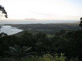
Geography
Mission Beach is bounded on the east by the Coral Sea. The popular tourist destination of Dunk Island lies 4 kilometres (2.5 mi) offshore.
Today, what were once separate villages have now grown such that they are considered one town, Mission Beach. The villages are, from south to north, South Mission Beach, Wongaling Beach, Mission Beach, Bingil Bay, Brooks Beach and Carmoo.[8] Development is also continuing at Garners Beach to the north.
Clump Point (17.8500°S 146.1166°E) is the northern end of a sandy beach 13 kilometres (8.1 mi) long facing the Coral Sea which runs south to Tam O'Shanter Point in South Mission Beach at the southern end (17.9666°S 146.1000°E).[9]
History
Clump Point (17.8500°S 146.1166°E) was descriptively named by Captain Owen Stanley of the Royal Navy survey ship HMS Rattlesnake.[10]
In 1872 it was alleged by two sailors (Wilson and Sullivan), that the captain (Stratman) and some of the crew of the ill-fated Maria which was wrecked in a "typhoon", were killed and eaten by Aboriginal people north of Tam O'Shanter Point. Survivor Thomas Ingham attests that the Aboriginal group were initially friendly with his party, until joined by another unfriendly group. A group of vigilantes raided the area now called South Mission Beach and attacked a local Aboriginal camp. In 1916 Ingham wrote: "Sub-Inspector Johnstone gave short-shrift to the cannibals, who had eaten the captains party, and the brutes who had speared me and taken my belt was seen to be wearing it around his head like a crown. That sealed his fate. This belt saved my life when I gave it to him. It made him a king when he crowned himself with it and bought about his demise. Sub-Inspector Johnstone gave it back to me, and I have kept it ever since."[11] The river Louisa was renamed Maria Creek after the wreck. Johnstone River was named after Sub Inspector Johnstone.
The first white settlers, the Cutten brothers, came to Mission Beach area in 1882 and settled at Bingil Bay, where they farmed mangoes, bananas, pineapples, coffee, citrus fruit and coconuts. They also manufactured their own coffee. Produce was shipped south on cargo-boats.[12] Before this the only white people to enter this area were the timber-getters who sometimes camped on the beach and retrieved timber from the adjacent rain forests. They employed local Aborigines for their assistance in their timber hauling, paying the Aboriginal labourers with tobacco and tools. After the Cutten brothers, the Unsworths settled at Narragon Beach, the Garners came and settled at Garners Beach, and the Porter brothers settled at what the locals refer to as Porter's Creek (also called Wongaling Creek) at the south end of North Mission Beach.
In the early 20th century Chinese banana farmers used Aboriginal people as labourers in the Tully River region. Opium addiction and conflict with European settlers resulted in the Queensland government creating an Aboriginal internment centre, the Hull River Aboriginal Settlement, at the present South Mission Beach. John Martin Kenny was appointed superintendent in September 1914. There was no mission in the religious sense; the settlement had characteristics of a penal settlement.[13] The whole settlement was destroyed in the cyclone of 10 March 1918 and Superintendent Kenny and his daughter were killed by debris. The surviving residents were forcibly moved to a new settlement on Great Palm Island.[14]
Mission Beach Post Office opened on 15 December 1949.[15]
Demographics
In the 2006 census Mission Beach had a population of 515.[16]
Education
Mission Beach State School opened on 27 January 1953[17] and is located at Webb Road Wongaling Beach.[18] It is a Prep to Year 6 school and details of the curriculum, facilities and resources can be found on the Mission Beach State School Website.
Festivals
In early October there is the evolve music festival than shows mostly local musicians and a few bands from around Australia. There is a market there that has food, clothes, jewellery, and other festival stuff.
Sport
Rugby League plays a big part in the town, with Tully Tigers the main club.
Tourism
Mission Beach is now a thriving tourist town that has been able to maintain its small town feel. One reason for this is that the town is spread out along a thin strip of land between the ocean and the hills and farmland behind. This has spread out a large tourism market, and the village doesn't feel as busy as one might expect.
The beach is flanked by green mountains rising just a short distance inland, and provides views out to the Family Islands. Close to shore at Mission Beach lies a shallow reef; during very low tides portions of this reef are exposed. The reef runs from the mouth of Porter's Creek at the south end of North Mission Beach almost to Clump Point, a popular fishing spot which is also the main departure and arrival point for the Dunk Island Ferry.
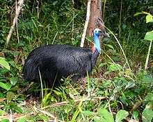
Surrounded by World Heritage rainforest on one side and the World Heritage listed Great Barrier Reef on the other, Mission Beach is home to many wildlife species, most notable is the cassowary. This large flightless bird can be found in the rainforest surrounding the area but appears to be thriving in spite of land clearing, traffic and predators such as wild dogs and feral pigs. Much of the area is part of the Coastal Wet Tropics Important Bird Area, identified as such by BirdLife International because of its importance for the conservation of lowland tropical rainforest birds.[19]
Mission Beach is also the mainland gateway to Dunk Island, with water taxis and ferries shuttling guests and day-trippers out to the island and its resort.
Like many other small Australian towns, Mission Beach has built a monument to its most famous characteristic. The big cassowary, standing 5 metres high, can be found at the Wongaling Beach shopping complex.
Cyclones
Cyclone Larry
On 20 March 2006, Cyclone Larry crossed the coast in between Mission Beach and Innisfail. In addition to structural damage to property, Cyclone Larry also had a tremendous impact on the rainforest and animals of the region, and it will take many years to recover. A shortage of rainforest fruit saw cassowaries seeking food in built up areas and, unfortunately, a number were hit and killed by cars.
Cyclone Yasi
On 3 February 2011, the eyewall of Severe Tropical Cyclone Yasi crossed the coast near Mission Beach. Wind gusts estimated up to 310 km/h (190 mph), leaving behind significant damage.[20] A storm surge estimated to have reached 0.7 m (2.3 ft) destroyed several structures along the coast and pushed up to 300 m (980 ft) inland.[21] In the hours after the storm's passage, police were unable to venture beyond their station grounds as the situation had yet to be declared safe. Most of the beach had lost its sand and all of the towns structures were damaged to some degree, with many houses completely destroyed. Near sunrise on 3 February, there were no reports of fatalities or injuries in Mission Beach.[22]
Agriculture
The Mission Beach area also supports a sizeable agricultural industry, particularly the cultivation of sugar and bananas. Boutique wineries specialising in tropical fruit wines can also be found in Mission Beach and nearby Kurrimine Beach.
In popular culture
- In Episode 7, Season One of The Real Housewives of Melbourne, the Housewives stayed at a five-star resort in Mission Beach.
- Series 2 and 3 of Escape from Scorpion Island was filmed at Mission Beach.
- The Australian television series Sea Patrol has filmed five of its series in the waters off the Mission Beach area.[23]
References
- Australian Bureau of Statistics (27 June 2017). "2016 Community Profiles: Mission Beach (State Suburb)". 2016 Census of Population and Housing. Retrieved 23 October 2017.

- "Mission Beach - town (entry 22309)". Queensland Place Names. Queensland Government. Retrieved 22 August 2016.
- "Mission Beach - locality (entry 45732)". Queensland Place Names. Queensland Government. Retrieved 22 August 2016.
- Australian Bureau of Statistics (27 June 2017). "2016 Community Profiles: Bingil Bay (State Suburb)". 2016 Census of Population and Housing. Retrieved 23 October 2017.
- Australian Bureau of Statistics (27 June 2017). "2016 Community Profiles: Wongaling Beach (State Suburb)". 2016 Census of Population and Housing. Retrieved 23 October 2017.
- Australian Bureau of Statistics (27 June 2017). "2016 Community Profiles: South Mission Beach (State Suburb)". 2016 Census of Population and Housing. Retrieved 23 October 2017.
- Australian Bureau of Statistics (27 June 2017). "2016 Community Profiles: Carmoo (State Suburb)". 2016 Census of Population and Housing. Retrieved 23 October 2017.
- Williams, Stephanie. "Guide to Mission Beach". Retrieved 28 August 2018.
- "Queensland Globe". State of Queensland. Retrieved 15 April 2018.
- "Tam O'Shanter Point (entry 33218)". Queensland Place Names. Queensland Government. Retrieved 28 August 2015.
- "Historical Society". The Telegraph (13, 556). Queensland, Australia. 4 May 1916. p. 3. Retrieved 22 August 2016 – via National Library of Australia.
- "IN MEMORIAM". Johnstone River Advocate And Innisfail News. XXVI (33). Queensland, Australia. 25 February 1930. p. 4. Retrieved 28 August 2018 – via National Library of Australia.
- "Hull River Mission: Impressions of a Visitor". Cairns Post. XXVIII (2282). 16 August 1915. p. 8. Retrieved 28 August 2018 – via National Library of Australia.
- "Care of Aborigines". The Telegraph (Brisbane) (14, 294 (Second Edition)). Queensland, Australia. 17 September 1918. p. 9. Retrieved 28 August 2018 – via National Library of Australia.
- Premier Postal History. "Post Office List". Premier Postal Auctions. Retrieved 10 May 2014.
- Australian Bureau of Statistics (25 October 2007). "Mission Beach (L) (Urban Centre/Locality)". 2006 Census QuickStats. Retrieved 13 June 2011.
- "Opening and closing dates of Queensland Schools". Queensland Government. Retrieved 18 April 2019.
- "Mission Beach State School". Mission Beach State School. January 2018. Archived from the original on 2 February 2018. Retrieved 2 February 2018.
- BirdLife International. (2011). Important Bird Areas factsheet: Coastal Wet Tropics. Downloaded from http://www.birdlife.org Archived 10 July 2007 at WebCite on 16 December 2011.
- Australian Associated Press (2 February 2011). "Yasi unleashing fury on Qld coast". The Sydney Morning Herald. Archived from the original on 2 February 2011. Retrieved 2 February 2011.
- Peter Michael (3 February 2011). "Morning heralds the big clean-up". Herald Sun. Archived from the original on 3 February 2011. Retrieved 3 February 2011.
- Petrina Berry (3 February 2011). "Damage extensive in Mission Beach". The Sydney Morning Herald. Australian Associated Press. Archived from the original on 2 February 2011. Retrieved 3 February 2011.
- "Cairns region battles to save TV drama". The Cairns Post. 28 October 2010. Retrieved 14 April 2011.
Further reading
| Wikimedia Commons has media related to Mission Beach, Queensland. |
- Pedley, Helen. "A Brief History of Mission Beach".
- Mission Beach History Archived website by Helen Pedley.
- University of Queensland: Queensland Places: Mission Beach