Ellis Beach, Queensland
Ellis Beach is a coastal locality in the Cairns Region, Queensland, Australia.[2] In the 2016 census, Ellis Beach had a population of 24 people.[1]
| Ellis Beach Queensland | |||||||||||||||
|---|---|---|---|---|---|---|---|---|---|---|---|---|---|---|---|
 Ellis Beach – view south to Buchan Point | |||||||||||||||
 Ellis Beach | |||||||||||||||
| Coordinates | 16.7322°S 145.6527°E | ||||||||||||||
| Population | 24 (2016 census)[1] | ||||||||||||||
| • Density | 1.71/km2 (4.44/sq mi) | ||||||||||||||
| Postcode(s) | 4879 | ||||||||||||||
| Area | 14.0 km2 (5.4 sq mi) | ||||||||||||||
| LGA(s) | Cairns Region | ||||||||||||||
| State electorate(s) | Barron River | ||||||||||||||
| Federal Division(s) | Leichhardt | ||||||||||||||
| |||||||||||||||
Geography
The five-kilometre strip of Ellis Beach is located aside the Coral Sea 20 kilometres (12 mi) north of Cairns on the Captain Cook Highway between Cairns and Port Douglas, within the Cairns Region local government area. The Ellis Beach locality also contains the nearby off-shore Double Island, also known by its native Aboriginal name Wangal Djungay.
History
Ellis Beach is situated in the Djabugay (Tjapukai) traditional Aboriginal country. [3] The Cairns Historical Society's records show that it was named after Dick Ellis, who at the time resided at this beach. He was a shot firer for the Queensland Department of Main Roads – presumably at the time the Cook Highway was constructed in the early 1930s. He lost a hand and the Queensland Government constructed a house for him at the beach now known as Ellis Beach on the spot where the café now stands. This was about 1940 and Dick Ellis died in 1960.
Before World War II the area was unnamed (in English) and had no houses. It was only during the war years that it became known as Ellis Beach and this fits with all other records. There are a number of mango trees at Ellis Beach, which it is believed were tended by Mr Ellis. After the construction of the Cook Highway through the area the authorities decided to plant many varieties of trees along each side of the roadway. This was done where the terrain permitted. Mangoes were particularly suitable for this purpose and many of the original trees survive along with other flowering trees. Those along the stretch of road at Ellis Beach would no doubt owe their existence to Dick Ellis. In other areas drought and fire have taken their toll but some still exist.
At the 2006 census, Ellis Beach had a population of 30.[4]
Amenities
Ellis Beach is also home to the Ellis Beach Surf Lifesaving Club which regularly hosts competitions and events. From November to May, a stinger net patrolled by the club helps protect swimmers from marine "stingers" (jellyfish species of Chironex and Irukandji) which inhabit the waters during those months. Ellis Beach features pumice stones along its beautiful shores.
There is a camping ground and a bar and grill restaurant.
In popular culture
Ellis Beach was featured in the fourth season of The Amazing Race.[5]
Gallery
 Ellis Beach – view north
 Jellyfish enclosure at Ellis Beach
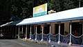 Ellis Beach Bar & Grill, 2018
References
- Australian Bureau of Statistics (27 June 2017). "Ellis Beach (SSC)". 2016 Census QuickStats. Retrieved 15 May 2018.

- "Ellis Beach - locality in Cairns Region (entry 48623)". Queensland Place Names. Queensland Government. Retrieved 30 July 2017.
- "First people cultural history". Cairns Regional Council. Retrieved 23 June 2020.
- Australian Bureau of Statistics (25 October 2007). "Ellis Beach (Cairns City) (State Suburb)". 2006 Census QuickStats. Retrieved 10 May 2011.
- "ARCHIVES: The Amazing Race 4". Game Show Newsnet. Archived from the original on 10 October 2008. Retrieved 1 January 2020.
External links
![]()