Saint-Siméon, Seine-et-Marne
Saint-Siméon (French: [sɛ̃.simeɔ̃] (![]()
Saint-Siméon | |
|---|---|
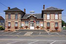 The town hall in Saint-Siméon | |
Location of Saint-Siméon 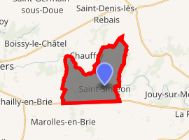
| |
 Saint-Siméon  Saint-Siméon | |
| Coordinates: 48°47′54″N 3°12′12″E | |
| Country | France |
| Region | Île-de-France |
| Department | Seine-et-Marne |
| Arrondissement | Provins |
| Canton | Coulommiers |
| Government | |
| • Mayor (2020–2026) | Renée Chabrillanges |
| Area 1 | 12.3 km2 (4.7 sq mi) |
| Population (2017-01-01)[1] | 896 |
| • Density | 73/km2 (190/sq mi) |
| Time zone | UTC+01:00 (CET) |
| • Summer (DST) | UTC+02:00 (CEST) |
| INSEE/Postal code | 77436 /77169 |
| Elevation | 80–150 m (260–490 ft) |
| 1 French Land Register data, which excludes lakes, ponds, glaciers > 1 km2 (0.386 sq mi or 247 acres) and river estuaries. | |
Demographics
Inhabitants of Saint-Siméon are called Saint-Siméonais.
gollark: Truly the mark of a successful open source project.
gollark: I might listen tomorrow when I'm not on my phone.
gollark: Have you considered using an actual license like creative commons or something?
gollark: Cool.
gollark: https://electronics.stackexchange.com/questions/2641/cheapest-fpgas
References
- "Populations légales 2017". INSEE. Retrieved 6 January 2020.
External links
| Wikimedia Commons has media related to Saint-Siméon (Seine-et-Marne). |
- 1999 Land Use, from IAURIF (Institute for Urban Planning and Development of the Paris-Île-de-France région) (in English)
- French Ministry of Culture list for Saint-Siméon (in French)
| Authority control |
|
|---|
This article is issued from Wikipedia. The text is licensed under Creative Commons - Attribution - Sharealike. Additional terms may apply for the media files.