Courpalay
Courpalay is a commune in the Seine-et-Marne department in the Île-de-France region in north-central France.
Courpalay | |
|---|---|
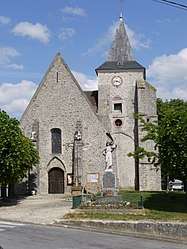 The church in Courpalay | |
.svg.png) Coat of arms | |
Location of Courpalay 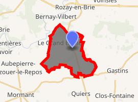
| |
 Courpalay  Courpalay | |
| Coordinates: 48°38′51″N 2°57′32″E | |
| Country | France |
| Region | Île-de-France |
| Department | Seine-et-Marne |
| Arrondissement | Provins |
| Canton | Fontenay-Trésigny |
| Intercommunality | CC Val Briard |
| Government | |
| • Mayor (2008–2014) | Charles Saadia |
| Area 1 | 14.56 km2 (5.62 sq mi) |
| Population (2017-01-01)[1] | 1,323 |
| • Density | 91/km2 (240/sq mi) |
| Time zone | UTC+01:00 (CET) |
| • Summer (DST) | UTC+02:00 (CEST) |
| INSEE/Postal code | 77135 /77540 |
| Elevation | 79–122 m (259–400 ft) |
| 1 French Land Register data, which excludes lakes, ponds, glaciers > 1 km2 (0.386 sq mi or 247 acres) and river estuaries. | |
Demographics
The inhabitants are called Courpaliens.
gollark: <@216135711793872897> If you mean crypto*mining* on pages, I block that as well as ads.
gollark: Java is a bad role model.
gollark: Anyway, consider queueing a table containing functions instead.
gollark: I mean, it is at least possible to have events containing functions.
gollark: Er, you can.
References
- "Populations légales 2017". INSEE. Retrieved 6 January 2020.
External links
| Wikimedia Commons has media related to Courpalay. |
- 1999 Land Use, from IAURIF (Institute for Urban Planning and Development of the Paris-Île-de-France région) (in English)
- French Ministry of Culture list for Courpalay (in French)
| Authority control |
|
|---|
This article is issued from Wikipedia. The text is licensed under Creative Commons - Attribution - Sharealike. Additional terms may apply for the media files.