Héricy
Héricy (French: [eʁisi] (![]()
Héricy | |
|---|---|
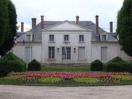 The town hall in Héricy | |
 Coat of arms | |
Location of Héricy 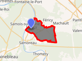
| |
 Héricy  Héricy | |
| Coordinates: 48°26′50″N 2°45′50″E | |
| Country | France |
| Region | Île-de-France |
| Department | Seine-et-Marne |
| Arrondissement | Fontainebleau |
| Canton | Fontainebleau |
| Intercommunality | CA Pays de Fontainebleau |
| Government | |
| • Mayor (2020–2026) | Yannick Torres |
| Area 1 | 10.68 km2 (4.12 sq mi) |
| Population (2017-01-01)[1] | 2,604 |
| • Density | 240/km2 (630/sq mi) |
| Time zone | UTC+01:00 (CET) |
| • Summer (DST) | UTC+02:00 (CEST) |
| INSEE/Postal code | 77226 /77850 |
| Elevation | 42–103 m (138–338 ft) |
| 1 French Land Register data, which excludes lakes, ponds, glaciers > 1 km2 (0.386 sq mi or 247 acres) and river estuaries. | |
Demographics
Inhabitants are called Héricéens.
gollark: I think there are 400Gbit/s things around. Probably hilariously expensive though.
gollark: Although said calculator is deliberately crippled in a few ways due to exams...
gollark: I still use an actual hardware calculator because I don't have anything I can run on a computer with the same featureset.
gollark: This isn't actually an economic crash at this point. reddit will probably run out of money.
gollark: Some bots use webhooks to look like arbitrary users with different avatars and usernames, can "pluralkit" do this?
References
- "Populations légales 2017". INSEE. Retrieved 6 January 2020.
External links
| Wikimedia Commons has media related to Héricy. |
- 1999 Land Use, from IAURIF (Institute for Urban Planning and Development of the Paris-Île-de-France région) (in English)
- French Ministry of Culture list for Héricy (in French)
| Authority control |
|
|---|
This article is issued from Wikipedia. The text is licensed under Creative Commons - Attribution - Sharealike. Additional terms may apply for the media files.