Crouy-sur-Ourcq
Crouy-sur-Ourcq is a commune in the Seine-et-Marne department in the Île-de-France region in north-central France.
Crouy-sur-Ourcq | |
|---|---|
 The town hall in Crouy-sur-Ourcq | |
.svg.png) Coat of arms | |
Location of Crouy-sur-Ourcq 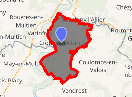
| |
 Crouy-sur-Ourcq  Crouy-sur-Ourcq | |
| Coordinates: 49°05′23″N 3°04′30″E | |
| Country | France |
| Region | Île-de-France |
| Department | Seine-et-Marne |
| Arrondissement | Meaux |
| Canton | La Ferté-sous-Jouarre |
| Intercommunality | Pays de l'Ourcq |
| Government | |
| • Mayor (2008–2014) | Michel Fouchault |
| Area 1 | 19.42 km2 (7.50 sq mi) |
| Population (2017-01-01)[1] | 1,914 |
| • Density | 99/km2 (260/sq mi) |
| Time zone | UTC+01:00 (CET) |
| • Summer (DST) | UTC+02:00 (CEST) |
| INSEE/Postal code | 77148 /77840 |
| Elevation | 52–165 m (171–541 ft) |
| 1 French Land Register data, which excludes lakes, ponds, glaciers > 1 km2 (0.386 sq mi or 247 acres) and river estuaries. | |
Demographics
Inhabitants of Crouy-sur-Ourcq are called Crouyciens.
Schools
The town has one preschool (école maternelle), one elementary school (école élémentaire), and the junior high school Collège le Champivert.[2]
gollark: Well, yes, inevitably.
gollark: It's accurate in 83% of cases.
gollark: Actually, I could use this for SPUDNET. Perhaps by abusing my DNS tunnel capability.
gollark: And their type etc.
gollark: It stores the statuses of all apioforms.
References
- "Populations légales 2017". INSEE. Retrieved 6 January 2020.
- "Ecoles et Périscolaire Archived 2016-04-15 at the Wayback Machine." Crouy-sur-Ourcq. Retrieved on September 3, 2016.
External links
| Wikimedia Commons has media related to Crouy-sur-Ourcq. |
- Home page (in French)
- 1999 Land Use, from IAURIF (Institute for Urban Planning and Development of the Paris-Île-de-France région) (in English)
- French Ministry of Culture list for Crouy-sur-Ourcq (in French)
| Authority control |
|
|---|
This article is issued from Wikipedia. The text is licensed under Creative Commons - Attribution - Sharealike. Additional terms may apply for the media files.