Égligny
Égligny (French: [egliɲi] (![]()
Égligny | |
|---|---|
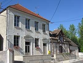 The school and town hall in Égligny | |
Location of Égligny 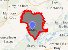
| |
 Égligny  Égligny | |
| Coordinates: 48°25′37″N 3°07′15″E | |
| Country | France |
| Region | Île-de-France |
| Department | Seine-et-Marne |
| Arrondissement | Provins |
| Canton | Provins |
| Intercommunality | CC Bassée - Montois |
| Government | |
| • Mayor (2014–2020) | Thierry Dequirot |
| Area 1 | 16.58 km2 (6.40 sq mi) |
| Population (2017-01-01)[1] | 331 |
| • Density | 20/km2 (52/sq mi) |
| Time zone | UTC+01:00 (CET) |
| • Summer (DST) | UTC+02:00 (CEST) |
| INSEE/Postal code | 77167 /77126 |
| Elevation | 50–135 m (164–443 ft) |
| 1 French Land Register data, which excludes lakes, ponds, glaciers > 1 km2 (0.386 sq mi or 247 acres) and river estuaries. | |
Demographics
Inhabitants of Égligny are called Églignyciens.
gollark: Compacting your entire political views into something like 24 bits is inevitably going to be lossy.
gollark: I mean, they're fun, you can plot everyone on a grid or something like I did for one discord server, but you should not define yourself or your beliefs by where you are on a grid.
gollark: ↑↑↑
gollark: Exactly!
gollark: I generally consider group violence a bad thing to be avoided.
References
- "Populations légales 2017". INSEE. Retrieved 6 January 2020.
External links
| Wikimedia Commons has media related to Égligny. |
- 1999 Land Use, from IAURIF (Institute for Urban Planning and Development of the Paris-Île-de-France région) (in English)
- French Ministry of Culture list for Égligny (in French)
This article is issued from Wikipedia. The text is licensed under Creative Commons - Attribution - Sharealike. Additional terms may apply for the media files.