Égreville
Égreville is a commune in the Seine-et-Marne department in the Île-de-France region in north-central France.
Égreville | |
|---|---|
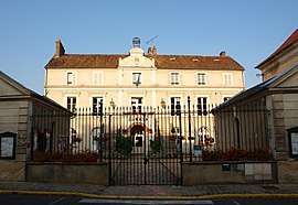 The town hall in Égreville | |
 Coat of arms | |
Location of Égreville 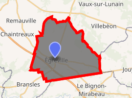
| |
 Égreville  Égreville | |
| Coordinates: 48°10′41″N 2°52′19″E | |
| Country | France |
| Region | Île-de-France |
| Department | Seine-et-Marne |
| Arrondissement | Fontainebleau |
| Canton | Nemours |
| Intercommunality | CC Gâtinais-Val de Loing |
| Government | |
| • Mayor (2008–2014) | Bruno Baschet |
| Area 1 | 31.84 km2 (12.29 sq mi) |
| Population (2017-01-01)[1] | 2,150 |
| • Density | 68/km2 (170/sq mi) |
| Time zone | UTC+01:00 (CET) |
| • Summer (DST) | UTC+02:00 (CEST) |
| INSEE/Postal code | 77168 /77620 |
| Elevation | 107–141 m (351–463 ft) |
| 1 French Land Register data, which excludes lakes, ponds, glaciers > 1 km2 (0.386 sq mi or 247 acres) and river estuaries. | |
Demographics
Inhabitants of Égreville are called Égrevillois.
gollark: ```|= end=@ :: 1=/ count=@ 1 :: 2|- :: 3^- (list @) :: 4?: =(end count) :: 5 ~ :: 6:- count :: 7$(count (add 1 count)) ```This is some utterly hellish hybrid of Lisp and... I don't even know.
gollark: Ugh, they use such arcane terminology like the rest of this project.
gollark: Oh, that insane thing.
gollark: https://media.discordapp.net/attachments/426116061415342080/770676605135487006/6g9ob0ox8cv51.png?width=796&height=422
gollark: Nope.
References
- "Populations légales 2017". INSEE. Retrieved 6 January 2020.
External links
| Wikimedia Commons has media related to Égreville. |
- 1999 Land Use, from IAURIF (Institute for Urban Planning and Development of the Paris-Île-de-France région) (in English)
- French Ministry of Culture list for Égreville (in French)
| Authority control |
|
|---|
This article is issued from Wikipedia. The text is licensed under Creative Commons - Attribution - Sharealike. Additional terms may apply for the media files.