Boissy-le-Châtel
Boissy-le-Châtel (French: [bwasi.lə.ʃatɛl] (![]()
Boissy-le-Châtel | |
|---|---|
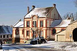 The town hall in Boissy-le-Châtel | |
 Coat of arms | |
Location of Boissy-le-Châtel 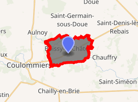
| |
 Boissy-le-Châtel  Boissy-le-Châtel | |
| Coordinates: 48°49′15″N 3°08′19″E | |
| Country | France |
| Region | Île-de-France |
| Department | Seine-et-Marne |
| Arrondissement | Meaux |
| Canton | Coulommiers |
| Intercommunality | CA Coulommiers Pays de Brie |
| Government | |
| • Mayor (2014–2020) | Guy Dhorbait |
| Area 1 | 9.95 km2 (3.84 sq mi) |
| Population (2017-01-01)[1] | 3,151 |
| • Density | 320/km2 (820/sq mi) |
| Time zone | UTC+01:00 (CET) |
| • Summer (DST) | UTC+02:00 (CEST) |
| INSEE/Postal code | 77042 /77169 |
| Elevation | 72–150 m (236–492 ft) |
| 1 French Land Register data, which excludes lakes, ponds, glaciers > 1 km2 (0.386 sq mi or 247 acres) and river estuaries. | |
Demographics
The inhabitants are called Buccéens.
Economy
gollark: libdatatape doesn't do byte by byte writing.
gollark: This seems like an overly fancy utility for modpack preparation.
gollark: What was that about techcorp?
gollark: You can listen on channel 31415, Anavrins' sniffer rebroadcasts most messages on that.
gollark: Already sort of exists.
References
- "Populations légales 2017". INSEE. Retrieved 6 January 2020.
External links
| Wikimedia Commons has media related to Boissy-le-Châtel. |
- Site on Boissy-le-Châtel (in French)
- 1999 Land Use, from IAURIF (Institute for Urban Planning and Development of the Paris-Île-de-France région)
- French Ministry of Culture list for Boissy-le-Châtel (in French)
| Authority control |
|
|---|
This article is issued from Wikipedia. The text is licensed under Creative Commons - Attribution - Sharealike. Additional terms may apply for the media files.