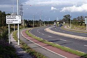
Regional road (Ireland)
A regional road (Irish: bóthar réigiúnach) in Ireland is a class of road not forming a major route (such as a national primary road or national secondary road), but nevertheless forming a link in the national route network. There are over 11,600 kilometres of regional roads.[1] Regional roads are numbered with three-digit route numbers, prefixed by "R" (e.g. R105).

History
Until 1977, classified roads in Ireland were designated with one of two prefixes: "T" for Trunk Roads and "L" for Link Roads. The Local Government (Roads and Motorways) Act authorised the designation of roads as National roads: in 1977, twenty-five National Primary roads (N1-N25) and thirty-three National Secondary roads (N51-N83) were initially designated under Statutory Instrument S.I. No. 164/1977.
Many of the remaining classified roads became Regional roads (formally authorised under the Roads Act 1993, having been indicated as such on road signs on a non-statutory basis for some years previously) and their routes were designated under a Statutory Instrument ('SI') in 1994. The latest SI designating the routes of Regional roads was published in 2012: the Roads Act 1993 (Classification of Regional Roads) Order 2012.
Other roads formerly classified as Trunk or Link roads eventually became Local roads.
Older signs showing the former Trunk and Link road designations are still to be seen in some locations. The L (for Link Road) prefix on these signs is not connected to the network of Local roads currently in place.
Features
Unlike national roads, regional roads are maintained by local county or city councils rather than the National Roads Authority. The vast majority of the regional road network is made up of single-carriageway roads although some roads are dual-carriageway (see: High-capacity regional roads below). Until the late 1990s, such roads were often in a very poor condition, although increased road maintenance funding to local councils has resulted in more frequent resurfacing of regional roads, as well as relaying and realignment on some routes.
Regional roads are generally subject to a speed limit of 80 km/h (imperial equivalent 50 mph), rather than the 100 km/h (imperial equivalent 62.5 mph) for national roads. Prior to 20 January 2005, when Ireland adopted metric speed limits, national and regional roads had identical speed limits of 60 mph. Regional roads, however, pass through towns, villages and built-up areas frequently, so even lower local speed restrictions are often in place. However, certain regional roads, often sections of former national roads which have been bypassed by motorways or other road improvements, have speed limits of 100 km/h. The R132 (former N1) is an example of a Regional road with a 100 km/h speed limit.
As of 2009, directional signposting on some regional roads in Ireland remains poor, with even modern signage usually relying on fingerpost signposts located directly at junctions. However, work on improving signposting on regional roads has been continuing since 2003; routes which previously had the most deficient signposting were selected for upgrading first. In 2007, a total of "€7 million to continue progress on the regional roads signposting programme, which commenced in 2003" was granted to local authorities.[2]
High-capacity regional roads
There are some higher-capacity (i.e. not just single-carriageway) sections of regional road, most notably the R113 (Belgard Road) and R445 (Old Naas Road), R132 Swords Inner By-pass and R136 Dublin Outer Ring Road which have sections of dual carriageway.
In some cases, important high-capacity urban routes are built or designated as regional roads, such as the mostly dual-carriageway R710 Waterford Outer Ring Road, or the R774 Greystones to the N11 link, which is dual-carriageway for its full length.
In many other cases, upgraded regional roads (for example, wide two-lane roads) were previously part of a national primary road, prior to the construction of a motorway or other bypass. In most cases, when a national primary road is changed by the creation of a bypass (motorway or other), the road previously forming part of the route is reclassified as a regional road rather than as a local road.
Route definitions
The current routes of all regional roads in Ireland – as defined by Statutory Instrument (S.I.) No 54/2012 (Classification of Regional Roads) Order 2012 under the Roads Act 1993 – are listed below. The S.I. specifies the start and end points of each route and the names of those townlands, villages, towns, and other settlements through which the route passes, as well as individual road names where necessary to establish the exact routing.
R101–R199


R200–R299


R300–R399


R400–R499


R500–R599


R600–R699


R700–R774


R801–R899


R900–R941


See also
- History of Roads in Ireland
- List of Ireland-related topics
- Local roads in Ireland
- Motorways in the Republic of Ireland
- National primary road
- National Roads Authority
- National secondary road
- Roads in Ireland
- Road signs in the Republic of Ireland
- Road speed limits in the Republic of Ireland
- Transport in Ireland
- Trunk Roads in Ireland
References
- "Archived copy" (PDF). Archived from the original (PDF) on 15 July 2011. Retrieved 15 July 2011.CS1 maint: archived copy as title (link) Roads Ireland, '€17 billion for roads', issue 4, 48.
- "Archived copy" (PDF). Archived from the original (PDF) on 15 July 2011. Retrieved 15 July 2011.CS1 maint: archived copy as title (link) Roads Ireland, 'Local roads get €600 million', issue 4, 55–57.
Sources
- Local Government (Roads and Motorways) Act, 1974
- S.I. No. 164/1977 — Local Government (Roads and Motorways) Act, 1974 (Declaration of National Roads) Order, 1977
- Roads Act, 1993
- S.I. No. 400/1994: Roads Act, 1993 (Declaration of Regional Roads) Order, 1994
- Roads Act 1993 (Classification of Regional Roads) Order 2006 – Department of Transport