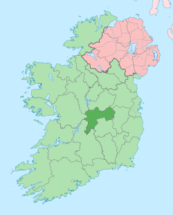
Edenderry
Edenderry (/ˌiːdənˈdɛri/; Irish: Éadan Doire, meaning "hill-brow of the oak wood"[3]) is a town in east County Offaly, Ireland. It is near the borders with Counties Kildare, Meath and Westmeath. The Grand Canal runs along the south of Edenderry, through the Bog of Allen, and there is a short spur to the town centre.
Edenderry Éadan Doire | |
|---|---|
Town | |
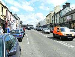 Main street Edenderry | |
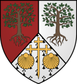 Coat of arms | |
| Motto(s): Esto Fideles - The Faithful | |
 Edenderry Location in Ireland | |
| Coordinates: 53.345°N 7.05116°W | |
| Country | Ireland |
| Province | Leinster |
| County | County Offaly |
| Elevation | 84 m (276 ft) |
| Population (2016)[1] | |
| • Urban | 7,359 |
| Time zone | UTC±0 (WET) |
| • Summer (DST) | UTC+1 (IST) |
| Eircode | R45 |
| Telephone area code | 046 |
| Irish Grid Reference | N633328 |
| Year | Pop. | ±% |
|---|---|---|
| 1831 | 1,283 | — |
| 1841 | 1,850 | +44.2% |
| 1851 | 1,804 | −2.5% |
| 1861 | 1,661 | −7.9% |
| 1871 | 1,873 | +12.8% |
| 1881 | 1,555 | −17.0% |
| 1891 | 1,577 | +1.4% |
| 1901 | 1,611 | +2.2% |
| 1911 | 2,208 | +37.1% |
| 1926 | 2,092 | −5.3% |
| 1936 | 2,093 | +0.0% |
| 1946 | 2,996 | +43.1% |
| 1951 | 2,596 | −13.4% |
| 1956 | 2,729 | +5.1% |
| 1961 | 2,794 | +2.4% |
| 1966 | 2,902 | +3.9% |
| 1971 | 3,116 | +7.4% |
| 1981 | 3,666 | +17.7% |
| 1986 | 3,753 | +2.4% |
| 1991 | 3,940 | +5.0% |
| 1996 | 3,825 | −2.9% |
| 2002 | 4,559 | +19.2% |
| 2006 | 5,818 | +27.6% |
| 2011 | 6,490 | +11.6% |
| 2016 | 7,359 | +13.4% |
| [2][1] | ||
The R401 road from Kinnegad to the north and the R402 from Enfield to the east meet at the northeastern end of the Main Street. At the Grand Canal they split, with the R402 continuing westwards towards Tullamore and the R401 heads south to Rathangan and Kildare Town.
History
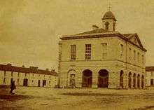
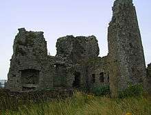
In the 16th century, Edenderry was known as Coolestown, after the family of Cooley or Cowley, who had a castle here. It was defended in 1599 against the Earl of Tyrone's rebellion. This subsequently passed by marriage to the Blundell family and was sacked in 1691 by the army of James II.[4]
The Blundells' land passed subsequently to the Marquess of Downshire who reversed the earlier opposition of the Blundell sisters to the establishment of a branch to the Grand Canal to Edenderry and paid for the £692 cost of the project,[5] which was completed in 1802.
By 1716 there was thriving woollen cloth manufacturing, established by Quakers, which employed around 1,000 people.[6] By 1911 the town had grown to 2,204 people. Other industries included the factory of Daniel Alesbury who made a variety of woodwork as well as the first car manufactured in Ireland, the Alesbury, in 1907.
Development and demographics
The town experienced some growth in the 1950s and 1960s, particularly with the building of peat burning power stations at Rhode, Allenwood and Portarlington by the Electricity Supply Board (ESB) and the Bord na Móna (BNM) peat briquette factories at Lullymore and Mountlucas. In addition, there was also seasonal harvesting of peat at Derrygreenagh and Lullymore, producing and harvesting machine turf at Rathangan. Most of these factories and works are now closed. BNM has diversified with the harvesting of peat and a provider of resource recovery, feedstock, retail services, environmental services and power generation.
The population of Edenderry almost doubled in the 20 years between the census of 1996 (when it had a population of 3,825 people)[7] and the 2016 census (which recorded a population of 7,359 people).[1]
Railways
A single railway track connected Edenderry to nearby Enfield or Innfield until 1963. The line provided both passenger and goods service until 1931, and goods only until it closed. In the years up to 1963 the line saw very infrequent service, and mostly carried livestock, sugar beet, and turf, as well as private excursions. Little remains of the line, except for occasional landmarks, such as the station house near the town centre on the Dublin road which is now a commercial business known as Station House Enterprises.
Most of the station yard and structures were intact until the late 1980s, with dual engine sheds, warehouse, loading gantries, a water tank, complete with a gantry hose, platforms and station master office. There was also a turntable basin located just behind the engine sheds, formed into the side of the hill with a 30' circular retaining wall on two sides, allowing engines to run in be turned and run out. Locally the town municipal water supply was highly chlorinated and at times impossible to drink. After the station was closed and the turntable was removed a spring in the turntable basin provided fresh water, and was known locally as "Coughlin's well! ". It continued to be used into the 1980s with Offaly County Council maintaining this site for a while. The spring was reached by a set of steps just beside the station master's house off Father Kearns street.
The line was begun in 1873 1.5 miles west of Innfield as a branch line, the Up only junction being called "Nesbitt Junction". Finance was provided by a Mrs. Nesbit. It was built by railway contractor Bagnell and opened four years later in 1877. Running and maintenance was by the Midland Great Western Railway (MGWR). With no through running for scheduled passenger traffic, it was considered a branch or slip line. For the journey to Dublin passengers from Edenderry would have to wait in the detached coach for a scheduled upbound train coming through the station, continuing on to Dublin or change platforms for westbound trains.
Local organisations
Organisations and businesses operating in the area include the Offaly Express newspaper and Edenderry Chamber of Commerce.[8]
Local sports clubs include Edenderry Rugby Club,[9] Edenderry GAA club,[10] Edenderry Town AFC,[11] and Highfield Golf Club.[12]
Notable people
- Neil Delamere, comedian[13]
- Frantic Jack, Irish Indie Rock band
- Josef Locke, entertainer[14]
- Malcolm Edward MacArthur (convicted murderer)
References
- "Sapmap Area - Settlements - Edenderry". Census 2016. CSO. 2016. Retrieved 12 January 2018.
- http://www.cso.ie/census and www.histpop.org. Post 1971 totals are for Edenderry urban and Edenderry environs. For a discussion on the accuracy of pre-famine census returns see JJ Lee “On the accuracy of the pre-famine Irish censuses” in Irish Population, Economy and Society edited by JM Goldstrom and LA Clarkson (1981) p54, and also “New Developments in Irish Population History, 1700-1850” by Joel Mokyr and Cormac Ó Gráda in The Economic History Review, New Series, Vol. 37, No. 4 (November 1984), pp. 473-488.
- P.W. Joyce (1972). Irish Place Names. EP Publishing.
- Lewis's Topographical Dictionary of Ireland. 1837.
- Mairead Evans & Therese Abbott. Safe Harbour, Grand Canal at Edenderry. Edenderry Historical Society.
- Michael Murphy (2004). Edenderry, A Leinster Town. Offaly County Council.
- "Demographic context" (PDF). Offaly County Council Development Plan 2009 - 2015. Archived from the original (PDF) on 30 October 2008. Retrieved 28 June 2008.
- Edenderry Chamber of Commerce
- Edenderry Rugby Club
- Edenderry GAA Club
- Edenderry Soccer Club
- Highfield Golf Club
- Reynolds, Dierdre (7 December 2014). "'I just think all performers are a bit weird...me included' - Neil Delamere". Irish Independent. Retrieved 5 December 2016.
- "A robust performer with a Derry air". Irish Times. 16 October 1999. Retrieved 5 December 2016.
External links
| Wikimedia Commons has media related to Edenderry, County Offaly. |
| Wikivoyage has a travel guide for Edenderry. |
