Ouarville
Ouarville is a commune in the Eure-et-Loir department in northern France.
Ouarville | |
|---|---|
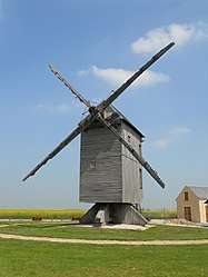 The windmill in Ouarville | |
 Coat of arms | |
Location of Ouarville 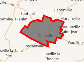
| |
 Ouarville  Ouarville | |
| Coordinates: 48°21′17″N 1°46′30″E | |
| Country | France |
| Region | Centre-Val de Loire |
| Department | Eure-et-Loir |
| Arrondissement | Chartres |
| Canton | Voves |
| Intercommunality | Beauce vovéenne |
| Government | |
| • Mayor (2001–2008) | Jean-Michel Dubief |
| Area 1 | 20.13 km2 (7.77 sq mi) |
| Population (2017-01-01)[1] | 524 |
| • Density | 26/km2 (67/sq mi) |
| Time zone | UTC+01:00 (CET) |
| • Summer (DST) | UTC+02:00 (CEST) |
| INSEE/Postal code | 28291 /28150 |
| Elevation | 146–154 m (479–505 ft) (avg. 150 m or 490 ft) |
| 1 French Land Register data, which excludes lakes, ponds, glaciers > 1 km2 (0.386 sq mi or 247 acres) and river estuaries. | |
Population
| Year | 1962 | 1968 | 1975 | 1982 | 1990 | 1999 | 2008 |
|---|---|---|---|---|---|---|---|
| Population | 387 | 425 | 408 | 425 | 468 | 549 | 577 |
gollark: Also, only me and aidan.
gollark: We can give you a special role.
gollark: Please put the fernmojis on O-R.
gollark: And also, <@!200256280185536512>, make me admin with admin powers or else.
gollark: Please set your nickname to your actual name there.
References
- "Populations légales 2017". INSEE. Retrieved 6 January 2020.
| Wikimedia Commons has media related to Ouarville. |
| Authority control |
|
|---|
This article is issued from Wikipedia. The text is licensed under Creative Commons - Attribution - Sharealike. Additional terms may apply for the media files.