Épeautrolles
Épeautrolles is a commune in the Eure-et-Loir department in northern France.
Épeautrolles | |
|---|---|
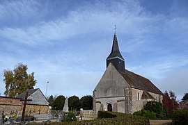
 The church in Épeautrolles | |
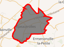
Location of Épeautrolles 
| |
 Épeautrolles  Épeautrolles | |
| Coordinates: 48°18′43″N 1°19′34″E | |
| Country | France |
| Region | Centre-Val de Loire |
| Department | Eure-et-Loir |
| Arrondissement | Chartres |
| Canton | Illiers-Combray |
| Intercommunality | Pays de Combray |
| Government | |
| • Mayor (2008–2014) | Bruno Taranne |
| Area 1 | 9.31 km2 (3.59 sq mi) |
| Population (2017-01-01)[1] | 186 |
| • Density | 20/km2 (52/sq mi) |
| Time zone | UTC+01:00 (CET) |
| • Summer (DST) | UTC+02:00 (CEST) |
| INSEE/Postal code | 28139 /28120 |
| Elevation | 150–167 m (492–548 ft) (avg. 160 m or 520 ft) |
| 1 French Land Register data, which excludes lakes, ponds, glaciers > 1 km2 (0.386 sq mi or 247 acres) and river estuaries. | |
Population
| Year | Pop. | ±% |
|---|---|---|
| 1793 | 189 | — |
| 1800 | 191 | +1.1% |
| 1806 | 228 | +19.4% |
| 1821 | 171 | −25.0% |
| 1831 | 250 | +46.2% |
| 1836 | 260 | +4.0% |
| 1841 | 229 | −11.9% |
| 1846 | 236 | +3.1% |
| 1851 | 255 | +8.1% |
| 1856 | 244 | −4.3% |
| 1861 | 255 | +4.5% |
| 1866 | 252 | −1.2% |
| 1872 | 247 | −2.0% |
| 1876 | 262 | +6.1% |
| 1881 | 237 | −9.5% |
| 1886 | 242 | +2.1% |
| 1891 | 218 | −9.9% |
| 1896 | 213 | −2.3% |
| 1901 | 224 | +5.2% |
| 1906 | 235 | +4.9% |
| 1911 | 217 | −7.7% |
| 1921 | 208 | −4.1% |
| 1926 | 218 | +4.8% |
| 1931 | 218 | +0.0% |
| 1936 | 263 | +20.6% |
| 1946 | 211 | −19.8% |
| 1954 | 159 | −24.6% |
| 1962 | 135 | −15.1% |
| 1968 | 116 | −14.1% |
| 1975 | 108 | −6.9% |
| 1982 | 127 | +17.6% |
| 1990 | 130 | +2.4% |
| 1999 | 147 | +13.1% |
| 2008 | 182 | +23.8% |
gollark: <@191756988344958977> The link says that that thing ended and it has put up a similar-looking but different thing.
gollark: The contract might have something in there about "we will cut you off if any abuse is suspected", who knows.
gollark: Of course. Why would they be able to provide logs without spending days reviewing logs?
gollark: Because money, I only have a desktop, running Linux.
gollark: I prefer to run linuxen.
References
- "Populations légales 2017". INSEE. Retrieved 6 January 2020.
| Wikimedia Commons has media related to Épeautrolles. |
This article is issued from Wikipedia. The text is licensed under Creative Commons - Attribution - Sharealike. Additional terms may apply for the media files.