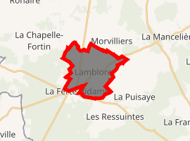
Lamblore
Lamblore is a commune in the Eure-et-Loir department in northern France.
Lamblore | |
|---|---|
Location of Lamblore 
| |
 Lamblore  Lamblore | |
| Coordinates: 48°37′33″N 0°55′10″E | |
| Country | France |
| Region | Centre-Val de Loire |
| Department | Eure-et-Loir |
| Arrondissement | Dreux |
| Canton | Saint-Lubin-des-Joncherets |
| Intercommunality | L'Orée du Perche |
| Government | |
| • Mayor (2008–2014) | Gérard Le Balc'h |
| Area 1 | 10.8 km2 (4.2 sq mi) |
| Population (2017-01-01)[1] | 333 |
| • Density | 31/km2 (80/sq mi) |
| Time zone | UTC+01:00 (CET) |
| • Summer (DST) | UTC+02:00 (CEST) |
| INSEE/Postal code | 28202 /28340 |
| Elevation | 214–252 m (702–827 ft) (avg. 232 m or 761 ft) |
| 1 French Land Register data, which excludes lakes, ponds, glaciers > 1 km2 (0.386 sq mi or 247 acres) and river estuaries. | |
Population
| Year | Pop. | ±% |
|---|---|---|
| 1962 | 263 | — |
| 1968 | 268 | +1.9% |
| 1975 | 214 | −20.1% |
| 1982 | 319 | +49.1% |
| 1990 | 358 | +12.2% |
| 1999 | 375 | +4.7% |
| 2008 | 400 | +6.7% |
gollark: Haskell loves linked lists.
gollark: Well, in my case, linked list.
gollark: I mean, it's a type declaration.
gollark: Wait, this is also not a variable declaration. Oh well.
gollark: There you go.
References
- "Populations légales 2017". INSEE. Retrieved 6 January 2020.
| Wikimedia Commons has media related to Lamblore. |
This article is issued from Wikipedia. The text is licensed under Creative Commons - Attribution - Sharealike. Additional terms may apply for the media files.