Francourville
Francourville is a commune in the Eure-et-Loir department in northern France.
Francourville | |
|---|---|
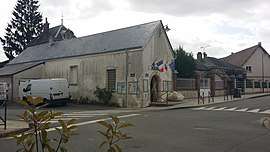 The town hall in Francourville | |
Location of Francourville 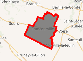
| |
 Francourville  Francourville | |
| Coordinates: 48°24′19″N 1°39′43″E | |
| Country | France |
| Region | Centre-Val de Loire |
| Department | Eure-et-Loir |
| Arrondissement | Chartres |
| Canton | Auneau |
| Intercommunality | Communauté d'agglomération Chartres métropole |
| Government | |
| • Mayor (2008–2014) | Philippe Varillon |
| Area 1 | 18.46 km2 (7.13 sq mi) |
| Population (2017-01-01)[1] | 833 |
| • Density | 45/km2 (120/sq mi) |
| Time zone | UTC+01:00 (CET) |
| • Summer (DST) | UTC+02:00 (CEST) |
| INSEE/Postal code | 28160 /28700 |
| Elevation | 137–157 m (449–515 ft) (avg. 157 m or 515 ft) |
| 1 French Land Register data, which excludes lakes, ponds, glaciers > 1 km2 (0.386 sq mi or 247 acres) and river estuaries. | |
Population
| Year | Pop. | ±% |
|---|---|---|
| 1962 | 473 | — |
| 1968 | 508 | +7.4% |
| 1975 | 475 | −6.5% |
| 1982 | 550 | +15.8% |
| 1990 | 805 | +46.4% |
| 1999 | 797 | −1.0% |
| 2008 | 783 | −1.8% |
| 2009 | 769 | −1.8% |
gollark: (psst! it's a prime number, so the factors are 1 and 17)
gollark: *factors the number 17**is a quantum computer*
gollark: There are already classical computer simulators for quantum stuff. It's just that quantum computers do the quantum stuff faster.
gollark: Serverless Centralized Quantum Blockchain.
gollark: Go is bad.
References
- "Populations légales 2017". INSEE. Retrieved 6 January 2020.
| Wikimedia Commons has media related to Francourville. |
| Authority control |
|
|---|
This article is issued from Wikipedia. The text is licensed under Creative Commons - Attribution - Sharealike. Additional terms may apply for the media files.