Orrouer
Orrouer is a commune in the Eure-et-Loir department in northern France.
Orrouer | |
|---|---|
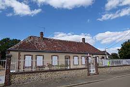 The town hall in Orrouer | |
Location of Orrouer 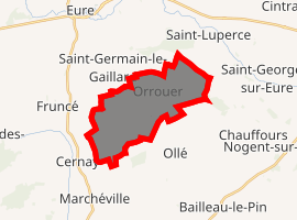
| |
 Orrouer  Orrouer | |
| Coordinates: 48°24′50″N 1°17′19″E | |
| Country | France |
| Region | Centre-Val de Loire |
| Department | Eure-et-Loir |
| Arrondissement | Chartres |
| Canton | Illiers-Combray |
| Intercommunality | Pays Courvillois |
| Government | |
| • Mayor (2010–2014) | Claude Féret |
| Area 1 | 13.25 km2 (5.12 sq mi) |
| Population (2017-01-01)[1] | 301 |
| • Density | 23/km2 (59/sq mi) |
| Time zone | UTC+01:00 (CET) |
| • Summer (DST) | UTC+02:00 (CEST) |
| INSEE/Postal code | 28290 /28190 |
| Elevation | 152–193 m (499–633 ft) (avg. 162 m or 531 ft) |
| 1 French Land Register data, which excludes lakes, ponds, glaciers > 1 km2 (0.386 sq mi or 247 acres) and river estuaries. | |
Population
| Year | Pop. | ±% |
|---|---|---|
| 1962 | 144 | — |
| 1968 | 164 | +13.9% |
| 1975 | 162 | −1.2% |
| 1982 | 186 | +14.8% |
| 1990 | 196 | +5.4% |
| 1999 | 239 | +21.9% |
| 2008 | 273 | +14.2% |
gollark: The staff team has roughly converged on "no extensive information gathering", which is roughly what the rule is.
gollark: I mean, the nobody thing was mostly a misunderstanding and he did not actually violate the rules *as we have now*.
gollark: That seems like a weird analogy.
gollark: Probably.
gollark: We judge stuff like, well, trolling "bad", which is subjective.
References
- "Populations légales 2017". INSEE. Retrieved 6 January 2020.
| Wikimedia Commons has media related to Orrouer. |
| Authority control |
|
|---|
This article is issued from Wikipedia. The text is licensed under Creative Commons - Attribution - Sharealike. Additional terms may apply for the media files.