Lucé, Eure-et-Loir
Lucé is a commune in the Eure-et-Loir department in northern France.
Lucé | |
|---|---|
.jpg) The church in Lucé | |
 Coat of arms | |
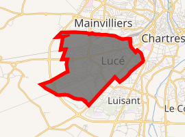
Location of Lucé 
| |
 Lucé  Lucé | |
| Coordinates: 48°26′20″N 1°27′57″E | |
| Country | France |
| Region | Centre-Val de Loire |
| Department | Eure-et-Loir |
| Arrondissement | Chartres |
| Canton | Lucé |
| Intercommunality | Chartres métropole |
| Government | |
| • Mayor (2008–2014) | Emmanuel Lecomte |
| Area 1 | 6.06 km2 (2.34 sq mi) |
| Population (2017-01-01)[1] | 15,404 |
| • Density | 2,500/km2 (6,600/sq mi) |
| Time zone | UTC+01:00 (CET) |
| • Summer (DST) | UTC+02:00 (CEST) |
| INSEE/Postal code | 28218 /28110 |
| Elevation | 142–162 m (466–531 ft) (avg. 157 m or 515 ft) |
| Website | Official website |
| 1 French Land Register data, which excludes lakes, ponds, glaciers > 1 km2 (0.386 sq mi or 247 acres) and river estuaries. | |
Population
| Year | Pop. | ±% |
|---|---|---|
| 1836 | 414 | — |
| 1841 | 413 | −0.2% |
| 1846 | 436 | +5.6% |
| 1851 | 484 | +11.0% |
| 1856 | 463 | −4.3% |
| 1861 | 494 | +6.7% |
| 1866 | 497 | +0.6% |
| 1872 | 530 | +6.6% |
| 1876 | 493 | −7.0% |
| 1881 | 532 | +7.9% |
| 1886 | 645 | +21.2% |
| 1891 | 658 | +2.0% |
| 1896 | 698 | +6.1% |
| 1901 | 800 | +14.6% |
| 1906 | 812 | +1.5% |
| 1911 | 948 | +16.7% |
| 1921 | 1,262 | +33.1% |
| 1926 | 1,283 | +1.7% |
| 1931 | 1,505 | +17.3% |
| 1936 | 1,497 | −0.5% |
| 1946 | 2,030 | +35.6% |
| 1954 | 3,303 | +62.7% |
| 1962 | 6,555 | +98.5% |
| 1968 | 11,085 | +69.1% |
| 1975 | 13,721 | +23.8% |
| 1982 | 17,433 | +27.1% |
| 1990 | 18,796 | +7.8% |
| 1999 | 17,701 | −5.8% |
| 2008 | 15,716 | −11.2% |
gollark: Wait, do I need to sacrifice RAMs or something to "God" to make it work?
gollark: Do all the monotheistic gods have annoying APIs like this?
gollark: Is Satan easier to reach?
gollark: Does this obey *any actual networking standard*?
gollark: I can't find "God".
This article is issued from Wikipedia. The text is licensed under Creative Commons - Attribution - Sharealike. Additional terms may apply for the media files.