Happonvilliers
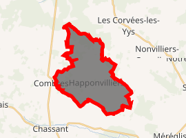
Happonvilliers is a commune in the Eure-et-Loir department in northern France.
Happonvilliers | |
|---|---|
.jpg) The town hall in Happonvilliers | |
Location of Happonvilliers 
| |
 Happonvilliers  Happonvilliers | |
| Coordinates: 48°19′33″N 1°06′44″E | |
| Country | France |
| Region | Centre-Val de Loire |
| Department | Eure-et-Loir |
| Arrondissement | Nogent-le-Rotrou |
| Canton | Nogent-le-Rotrou |
| Intercommunality | Perche thironnais |
| Government | |
| • Mayor (2008–2014) | Denise Huillery |
| Area 1 | 18.96 km2 (7.32 sq mi) |
| Population (2017-01-01)[1] | 307 |
| • Density | 16/km2 (42/sq mi) |
| Time zone | UTC+01:00 (CET) |
| • Summer (DST) | UTC+02:00 (CEST) |
| INSEE/Postal code | 28192 /28480 |
| Elevation | 183–256 m (600–840 ft) (avg. 218 m or 715 ft) |
| 1 French Land Register data, which excludes lakes, ponds, glaciers > 1 km2 (0.386 sq mi or 247 acres) and river estuaries. | |
Population
| Year | Pop. | ±% |
|---|---|---|
| 1962 | 241 | — |
| 1968 | 282 | +17.0% |
| 1975 | 240 | −14.9% |
| 1982 | 235 | −2.1% |
| 1990 | 235 | +0.0% |
| 1999 | 267 | +13.6% |
| 2008 | 308 | +15.4% |
gollark: Reason #124015 to run adblockers.
gollark: Good luck making your friends switch away from Facebook Messenger or whatever.
gollark: VPNs are not really a fix.
gollark: Like how people would generally not want to go around going to the toilet in a glass cube or something.
gollark: Well, there are the pragmatic grounds, really, like that, and the more terminal-goal-y one of "this much information on people is kind of icky".
References
- "Populations légales 2017". INSEE. Retrieved 6 January 2020.
| Wikimedia Commons has media related to Happonvilliers. |
This article is issued from Wikipedia. The text is licensed under Creative Commons - Attribution - Sharealike. Additional terms may apply for the media files.