Billancelles
Billancelles is a commune in the Eure-et-Loir department in northern France.
Billancelles | |
|---|---|
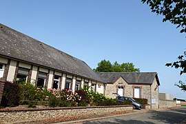 The town hall in Billancelles | |
Location of Billancelles 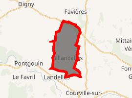
| |
 Billancelles  Billancelles | |
| Coordinates: 48°29′17″N 1°12′57″E | |
| Country | France |
| Region | Centre-Val de Loire |
| Department | Eure-et-Loir |
| Arrondissement | Chartres |
| Canton | Illiers-Combray |
| Intercommunality | Pays Courvillois |
| Government | |
| • Mayor (2008–2014) | Jean-Marc Bonnet |
| Area 1 | 11.95 km2 (4.61 sq mi) |
| Population (2017-01-01)[1] | 324 |
| • Density | 27/km2 (70/sq mi) |
| Time zone | UTC+01:00 (CET) |
| • Summer (DST) | UTC+02:00 (CEST) |
| INSEE/Postal code | 28040 /28190 |
| Elevation | 181–222 m (594–728 ft) (avg. 195 m or 640 ft) |
| 1 French Land Register data, which excludes lakes, ponds, glaciers > 1 km2 (0.386 sq mi or 247 acres) and river estuaries. | |
Population
| Year | Pop. | ±% |
|---|---|---|
| 1962 | 192 | — |
| 1968 | 217 | +13.0% |
| 1975 | 191 | −12.0% |
| 1982 | 192 | +0.5% |
| 1990 | 216 | +12.5% |
| 1999 | 213 | −1.4% |
| 2008 | 277 | +30.0% |
gollark: Yes, someone really should have come up with a better input method by now.
gollark: I see.
gollark: Although I haven't looked very hard.
gollark: The current consumer DNA test things seem to not be very privacy friendly.
gollark: You would probably know about *most* of the preexisting conditions.
References
- "Populations légales 2017". INSEE. Retrieved 6 January 2020.
| Wikimedia Commons has media related to Billancelles. |
| Authority control |
|
|---|
This article is issued from Wikipedia. The text is licensed under Creative Commons - Attribution - Sharealike. Additional terms may apply for the media files.