National Register of Historic Places listings in Wilkes County, Georgia
This is a list of properties and districts in Wilkes County, Georgia that are listed on the National Register of Historic Places (NRHP).
- This National Park Service list is complete through NPS recent listings posted August 14, 2020.[1]
Current listings
| [2] | Name on the Register | Image | Date listed[3] | Location | City or town | Description |
|---|---|---|---|---|---|---|
| 1 | Anderson House | September 29, 1976 (#76000657) |
GA 44 33°52′05″N 82°39′10″W |
Danburg | ||
| 2 | Arnold-Callaway Plantation | 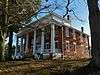 Arnold-Callaway Plantation |
April 11, 1972 (#72000402) |
NW of Washington on U.S. 78 33°46′27″N 82°48′46″W |
Washington | |
| 3 | Campbell-Jordan House | 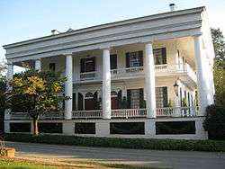 Campbell-Jordan House |
July 14, 1971 (#71000288) |
208 Liberty St. 33°44′01″N 82°44′15″W |
Washington | |
| 4 | The Cedars | 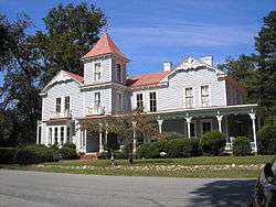 The Cedars |
April 11, 1972 (#72000403) |
210 Sims St. 33°44′29″N 82°44′19″W |
Washington | |
| 5 | Cherry Grove Baptist Church Schoolhouse | June 23, 2020 (#100005300) |
1878 Danburg Rd. 33°46′15″N 82°41′16″W |
Washington vicinity | ||
| 6 | James and Cunningham Daniel House | .jpg) James and Cunningham Daniel House |
November 24, 1980 (#80001266) |
S of Rayle on Bartram Trace Rd. 33°40′59″N 82°54′35″W |
Rayle | |
| 7 | East Robert Toombs Historic District | 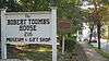 East Robert Toombs Historic District |
April 11, 1972 (#72000404) |
East Robert Toombs Ave. between Alexander Ave. and Grove St. 33°44′12″N 82°44′12″W |
Washington | |
| 8 | Fitzpatrick Hotel | 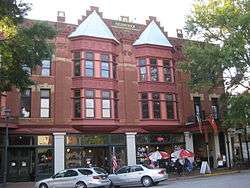 Fitzpatrick Hotel |
December 17, 1982 (#82000147) |
18 W. Public Square 33°44′14″N 82°44′24″W |
Washington | |
| 9 | Gartrell Family House | June 14, 2002 (#02000629) |
854 Boyd Rd. 33°55′28″N 82°46′24″W |
Tignall | ||
| 10 | Gilbert-Alexander House | 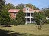 Gilbert-Alexander House |
April 11, 1972 (#72000405) |
116 Alexander Dr. 33°44′28″N 82°44′14″W |
Washington | |
| 11 | Thomas M. Gilmer House | November 2, 1977 (#77001540) |
5 miles (8.0 km) W of Washington on U.S. 78 33°58′38″N 82°50′07″W |
Washington | ||
| 12 | Holly Court | 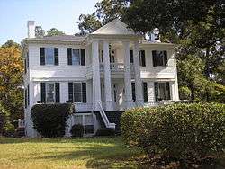 Holly Court |
April 11, 1972 (#72000406) |
301 S. Alexander St. 33°44′00″N 82°44′12″W |
Washington | |
| 13 | Kettle Creek Battlefield | 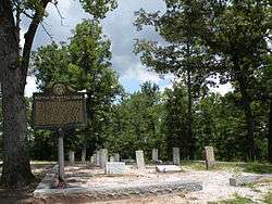 Kettle Creek Battlefield |
June 26, 1975 (#75000617) |
9 miles (14 km) SW of Washington off Tyrone Rd. 33°41′26″N 82°53′11″W |
Washington | |
| 14 | Mary Willis Library | 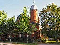 Mary Willis Library |
April 11, 1972 (#72000407) |
204 E. Liberty (at S. Jefferson St.) 33°44′07″N 82°44′17″W |
Washington | |
| 15 | North Washington District | March 7, 1973 (#73000649) |
Bounded by Jefferson and Court Sts., Poplar Dr., and U.S. 78 33°44′40″N 82°44′22″W |
Washington | ||
| 16 | Old Jail | 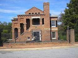 Old Jail |
June 5, 1974 (#74000706) |
103 Court St. 33°44′20″N 82°44′28″W |
Washington | |
| 17 | Peacewood | April 11, 1972 (#72000408) |
120 Tignall Rd. 33°45′20″N 82°44′08″W |
Washington | ||
| 18 | Pharr-Callaway-Sethness House | March 26, 1976 (#76000659) |
N of Tignall on GA 2193 33°56′14″N 82°44′12″W |
Tignall | ||
| 19 | Poplar Corner | April 11, 1972 (#72000409) |
210 W. Liberty St. 33°44′03″N 82°44′35″W |
Washington | ||
| 20 | Robert Shand Smith House | November 7, 2002 (#02001294) |
902 S. Spring St. 33°43′33″N 82°44′35″W |
Washington | ||
| 21 | Robert Toombs House | 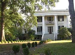 Robert Toombs House |
April 11, 1972 (#72000410) |
216 E. Robert Toombs Ave. 33°44′10″N 82°44′02″W |
Washington | A National Historic Landmark and a Georgia state historic site |
| 22 | Tupper-Barnett House | .jpg) Tupper-Barnett House |
April 11, 1972 (#72000411) |
101 W. Robert Toombs Ave. 33°44′14″N 82°44′28″W |
Washington | National Historic Landmark |
| 23 | Washington Commercial Historic District | 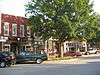 Washington Commercial Historic District |
March 6, 1986 (#86000412) |
Roughly bounded by Court St., Jefferson St., Robert Toombs Ave., and Allison St. 33°44′14″N 82°44′22″W |
Washington | |
| 24 | Washington Historic District | December 6, 2004 (#04001319) |
Centered on West Robert Toombs Ave. and N. Alexander St. 33°44′07″N 82°44′34″W |
Washington | ||
| 25 | Washington Presbyterian Church | _Presbyterian_Church.JPG) Washington Presbyterian Church |
April 11, 1972 (#72000412) |
206 E. Robert Toombs Ave. 33°44′08″N 82°44′10″W |
Washington | |
| 26 | Washington-Wilkes Historical Museum | 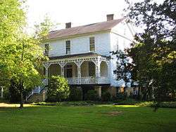 Washington-Wilkes Historical Museum |
May 13, 1970 (#70000227) |
308 E. Robert Toombs Ave. 33°44′07″N 82°44′03″W |
Washington | |
| 27 | West Robert Toombs District | March 1, 1973 (#73000650) |
W. Robert Toombs Ave. between Allison St. and Rte. 44 and Lexington Ave. 33°44′10″N 82°44′50″W |
Washington | ||
| 28 | Wilkes County Courthouse | 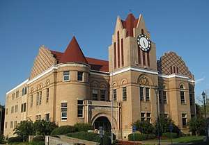 Wilkes County Courthouse |
September 18, 1980 (#80001267) |
Court St. 33°44′17″N 82°44′22″W |
Washington | |
| 29 | Willis-Sale-Stennett House | October 14, 1976 (#76000658) |
N of Danburg off GA 79 on SR 1445 33°55′33″N 82°39′16″W |
Danburg |
gollark: There's nothing intrinsically wrong with them. They're pretty competitive in lots of price ranges.
gollark: It's very high-bandwidth and fast so it's useful to the GPU, though.
gollark: It is technically possible, but no.
gollark: At this point, books, movies, images and anything else you can put on a computer is (sort of) just an extremely large number.
gollark: Lots of things are just numbers. Some numbers are useful.
References
- "National Register of Historic Places: Weekly List Actions". National Park Service, United States Department of the Interior. Retrieved on August 14, 2020.
- Numbers represent an ordering by significant words. Various colorings, defined here, differentiate National Historic Landmarks and historic districts from other NRHP buildings, structures, sites or objects.
- The eight-digit number below each date is the number assigned to each location in the National Register Information System database, which can be viewed by clicking the number.
| Wikimedia Commons has media related to National Register of Historic Places in Wilkes County, Georgia. |
This article is issued from Wikipedia. The text is licensed under Creative Commons - Attribution - Sharealike. Additional terms may apply for the media files.