National Register of Historic Places listings in Jackson County, Georgia
This is a list of properties and districts in Jackson County, Georgia that are listed on the National Register of Historic Places (NRHP).
- This National Park Service list is complete through NPS recent listings posted August 14, 2020.[1]
Current listings
| [2] | Name on the Register | Image | Date listed[3] | Location | City or town | Description |
|---|---|---|---|---|---|---|
| 1 | Braselton Historic District | 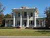 Braselton Historic District |
April 27, 2001 (#01000384) |
Jct. of GA 124 and GA 53 34°06′33″N 83°45′48″W |
Braselton | |
| 2 | Commerce Commercial Historic District | Commerce Commercial Historic District |
January 19, 1989 (#88003226) |
Roughly bounded by Line, State, Cherry, Sycamore and Broad Sts. 34°12′13″N 83°27′24″W |
Commerce | |
| 3 | Governor L. G. Hardman House | June 16, 1988 (#88000749) |
208 Elm St. 34°12′04″N 83°27′22″W |
Commerce | ||
| 4 | Hillcrest-Allen Clinic and Hospital |  Hillcrest-Allen Clinic and Hospital |
May 2, 1985 (#85000936) |
GA 53 & Peachtree Rd. 34°05′18″N 83°45′29″W |
Hoschton | |
| 5 | Holder Plantation | September 5, 1990 (#90001408) |
Jct. of Possum Creek Rd. and US 129 34°09′03″N 83°37′13″W |
Jefferson | ||
| 6 | Hoschton Depot | 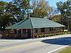 Hoschton Depot |
March 31, 2000 (#00000304) |
4276 GA 53 34°05′49″N 83°45′41″W |
Hoschton | |
| 7 | Jackson County Courthouse | 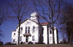 Jackson County Courthouse |
September 18, 1980 (#80001096) |
GA 1 34°07′06″N 83°34′28″W |
Jefferson | |
| 8 | Jefferson Historic District | 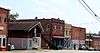 Jefferson Historic District |
March 26, 2003 (#03000137) |
Roughly centered on the downtown central business district of Jefferson extending to city limits to NW and SW 34°07′01″N 83°34′42″W |
Jefferson | |
| 9 | Maysville Historic District | 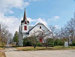 Maysville Historic District |
September 12, 1985 (#85002203) |
Along E. Main, W. Main and Homer Sts. 34°15′17″N 83°33′48″W |
Maysville | |
| 10 | Oak Avenue Historic District | May 30, 2002 (#02000564) |
S of jct. of Oak Ave. and the Southern RR 34°06′36″N 83°34′47″W |
Jefferson | ||
| 11 | Paradise Cemetery | 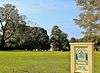 Paradise Cemetery |
May 30, 2002 (#02000563) |
E of Southern RR bet. Lawrenceville St. and Mahaffey Circle 34°07′08″N 83°34′56″W |
Jefferson | |
| 12 | Seaborn M. Shankle House | November 29, 1979 (#79000732) |
125 Cherry St 34°12′09″N 83°27′18″W |
Commerce | ||
| 13 | Shields-Etheridge Farm | June 25, 1992 (#92000814) |
Jct. of GA 319 and Co. Rd. 125, approximately 5 mi. SW of Jefferson 34°04′05″N 83°35′27″W |
Jackson | ||
| 14 | Talmo Historic District | 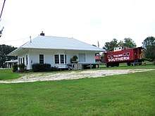 Talmo Historic District |
September 15, 1997 (#97000960) |
Roughly along Main St., Kinney Ave., and A.J. Irvin Rd. 34°11′06″N 83°43′13″W |
Talmo | |
| 15 | Williamson-Maley-Turner Farm | July 7, 1995 (#95000823) |
GA 15 NE of Jefferson 34°08′52″N 83°31′10″W |
Jefferson |
gollark: Maybe I should make a quadratic model!
gollark: I have r = -0.224, so clearly my model is great.
gollark: 65, sure.
gollark: With a correlation *this* strong, I don't think it actually can be wrong.
gollark: Ah, I see.
References
- "National Register of Historic Places: Weekly List Actions". National Park Service, United States Department of the Interior. Retrieved on August 14, 2020.
- Numbers represent an ordering by significant words. Various colorings, defined here, differentiate National Historic Landmarks and historic districts from other NRHP buildings, structures, sites or objects.
- The eight-digit number below each date is the number assigned to each location in the National Register Information System database, which can be viewed by clicking the number.
| Wikimedia Commons has media related to National Register of Historic Places in Jackson County, Georgia. |
This article is issued from Wikipedia. The text is licensed under Creative Commons - Attribution - Sharealike. Additional terms may apply for the media files.