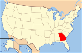
National Register of Historic Places listings in Banks County, Georgia
This is a list of properties and districts in Banks County, Georgia that are listed on the National Register of Historic Places (NRHP).
- This National Park Service list is complete through NPS recent listings posted August 14, 2020.[1]
Current listings
| [2] | Name on the Register | Image | Date listed[3] | Location | City or town | Description |
|---|---|---|---|---|---|---|
| 1 | Banks County Courthouse | .jpg) Banks County Courthouse |
September 18, 1980 (#80000969) |
Off U.S. 441 34°20′05″N 83°29′56″W |
Homer | |
| 2 | Banks County Jail | 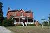 Banks County Jail |
July 26, 1982 (#82002382) |
Silver Shoals Rd. 34°20′06″N 83°29′20″W |
Homer | |
| 3 | Brooks Family Farm | 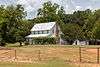 Brooks Family Farm |
July 23, 2013 (#13000529) |
584 Silver Shoals Rd. 34°22′14″N 83°33′14″W |
Lula | |
| 4 | William Chambers House | .JPG) William Chambers House |
November 7, 1996 (#96001305) |
GA 51, approximately 1 mi. W of jct. with GA 63 34°22′15″N 83°25′13″W |
Homer | |
| 5 | Fort Hollingsworth-White House | .JPG) Fort Hollingsworth-White House |
August 6, 1998 (#19980806) |
Wynn Lake Rd., 2 mi. SE of Hollingsworth 34°25′35″N 83°32′02″W |
Hollingsworth | |
| 6 | Gillsville Historic District | 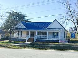 Gillsville Historic District |
August 30, 1985 (#85001933) |
GA 52 34°18′38″N 83°38′20″W |
Gillsville | |
| 7 | Hebron Church, Cemetery, and Academy | .JPG) Hebron Church, Cemetery, and Academy |
September 12, 1985 (#85002176) |
Hebron Circle 34°17′12″N 83°21′53″W |
Commerce | |
| 8 | Homer Historic District | .JPG) Homer Historic District |
December 3, 1985 (#85003110) |
Along Main St. and Silver Shoals Rd. 34°19′59″N 83°29′52″W |
Homer | |
| 9 | Kesler Covered Bridge | June 18, 1975 (#75000571) |
10 mi. N of Homer on County Line Rd. over Middle Fork Broad River 34°25′27″N 83°23′16″W |
Homer | ||
| 10 | Maysville Historic District | 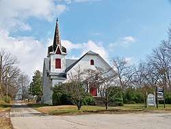 Maysville Historic District |
September 12, 1985 (#85002203) |
Along E. Main, W. Main and Homer Sts. 34°15′17″N 83°33′48″W |
Maysville | |
| 11 | Mount Pleasant Historic District | .JPG) Mount Pleasant Historic District |
November 7, 1996 (#96001306) |
Jct. of GA 51 and Damascus Road 34°21′53″N 83°26′33″W |
Homer | |
| 12 | Nails Creek Historic District |  Nails Creek Historic District |
November 7, 1996 (#96001307) |
Jct. of GA 51 and GA 63 34°22′00″N 83°24′02″W |
Homer | |
| 13 | New Salem Covered Bridge | June 10, 1975 (#75000570) |
6 mi. N of Commerce on SR S992 over Grove Creek 34°15′30″N 83°25′20″W |
Commerce | ||
| 14 | Turk Family Farm | January 8, 2003 (#03001365) |
534 Carson Segars Rd. 34°17′37″N 83°32′43″W |
Maysville |
gollark: Oh, oops, forgot to actually add mods.
gollark: This will take up to 49 minutes or more.
gollark: Good news! Using the bee algorithm™, I have determined that it is now approximately time to make your "mine craft" server.
gollark: I'm busy working on important things like the fully automated bee eugenics machine.
gollark: I don't have great automation for it, so configuring a new server would take up to 2 hours or less.
References
- "National Register of Historic Places: Weekly List Actions". National Park Service, United States Department of the Interior. Retrieved on August 14, 2020.
- Numbers represent an ordering by significant words. Various colorings, defined here, differentiate National Historic Landmarks and historic districts from other NRHP buildings, structures, sites or objects.
- The eight-digit number below each date is the number assigned to each location in the National Register Information System database, which can be viewed by clicking the number.
| Wikimedia Commons has media related to National Register of Historic Places in Banks County, Georgia. |
| Topics | |
|---|---|
| Lists by state |
|
| Lists by insular areas | |
| Lists by associated state | |
| Other areas | |
| Related | |
| |
This article is issued from Wikipedia. The text is licensed under Creative Commons - Attribution - Sharealike. Additional terms may apply for the media files.