National Register of Historic Places listings in Chattooga County, Georgia
This is a list of properties and districts in Chattooga County, Georgia that are listed on the National Register of Historic Places (NRHP).
- This National Park Service list is complete through NPS recent listings posted August 14, 2020.[1]
Current listings
| [2] | Name on the Register | Image | Date listed[3] | Location | City or town | Description |
|---|---|---|---|---|---|---|
| 1 | Camp Juliette Low | September 1, 1987 (#87001431) |
GA 157 34°31′57″N 85°28′51″W |
Cloudland | ||
| 2 | Chattooga County Courthouse | 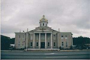 Chattooga County Courthouse |
September 18, 1980 (#80000988) |
Courthouse Sq. 34°28′49″N 85°20′55″W |
Summerville | |
| 3 | Georgia Site No. 9 CG 43 | December 20, 1987 (#87002112) |
Address Restricted |
Summerville | ||
| 4 | Paradise Gardens |  Paradise Gardens |
March 27, 2012 (#12000166) |
200 N. Lewis Street 34°30′47″N 85°19′00″W |
Pennville | |
| 5 | Penn Place | 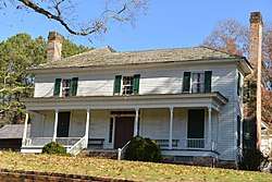 Penn Place |
September 29, 1988 (#88001828) |
Penn Bridge Rd. 34°31′16″N 85°18′10″W |
Trion | |
| 6 | Riegel Hospital | February 20, 2002 (#02000079) |
194 Allgood St. 34°32′31″N 85°18′46″W |
Trion | Demolished in 2010 | |
| 7 | Sardis Baptist Church | 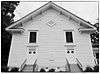 Sardis Baptist Church |
August 21, 1997 (#97000862) |
Junction of GA 114 and Sardis Church Rd. 34°21′09″N 85°26′37″W |
Lyerly | |
| 8 | Summerville Commercial Historic District | .jpg) Summerville Commercial Historic District |
May 16, 2012 (#12000280) |
Centered around Commerce St., Georgia, & Washington Aves. 34°28′48″N 85°20′54″W |
Summerville | |
| 9 | Summerville Depot | 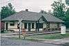 Summerville Depot |
January 29, 1992 (#91002037) |
120 E. Washington Ave. 34°28′47″N 85°20′46″W |
Summerville |
gollark: * just
gollark: Maybe your USB WiFi stick is ust bad.
gollark: Why even use WiFi when we have transcrustal neutrino pipelines nowadays?
gollark: Can you NOT simply buy a wireless card/USB stick/apiocuboid?
gollark: S is after R in the alphabet, so this is true.
References
- "National Register of Historic Places: Weekly List Actions". National Park Service, United States Department of the Interior. Retrieved on August 14, 2020.
- Numbers represent an ordering by significant words. Various colorings, defined here, differentiate National Historic Landmarks and historic districts from other NRHP buildings, structures, sites or objects.
- The eight-digit number below each date is the number assigned to each location in the National Register Information System database, which can be viewed by clicking the number.
| Wikimedia Commons has media related to National Register of Historic Places in Chattooga County, Georgia. |
This article is issued from Wikipedia. The text is licensed under Creative Commons - Attribution - Sharealike. Additional terms may apply for the media files.