National Register of Historic Places listings in Talbot County, Georgia
This is a list of properties and districts in Talbot County, Georgia that are listed on the National Register of Historic Places (NRHP).
- This National Park Service list is complete through NPS recent listings posted August 14, 2020.[1]
Current listings
| [2] | Name on the Register | Image | Date listed[3] | Location | City or town | Description |
|---|---|---|---|---|---|---|
| 1 | Frederick A. Bailey House |  Frederick A. Bailey House |
September 4, 1980 (#80001238) |
U.S. 80 32°39′26″N 84°32′06″W |
Talbotton | Early interpretation of Greek Revival style, built in 1837. |
| 2 | Newton P. Carreker House | 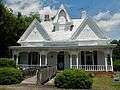 Newton P. Carreker House |
August 26, 1980 (#80001239) |
344 Jackson St. 32°40′46″N 84°32′21″W |
Talbotton | |
| 3 | The Elms | .JPG) The Elms |
September 4, 2004 (#04000930) |
GA 36 at 47 Rising Sun Rd., 3 mi. east of Woodland. 32°47′23″N 84°30′24″W |
Woodland | Circa 1838 |
| 4 | LeVert Historic District | %3B_Talbotton%2C_GA_(NRHP).JPG) LeVert Historic District |
January 11, 1976 (#76000649) |
Roughly bounded by Washington Ave., railroad tracks, Madison and Smith Sts. 32°40′28″N 84°32′19″W |
Talbotton | |
| 5 | Lockhart-Cosby Plantation | .JPG) Lockhart-Cosby Plantation |
October 14, 1994 (#94001215) |
GA 208 7 mi. E of Talbotton 32°38′38″N 84°22′48″W |
Talbot | |
| 6 | John Frank Mathews Plantation | .JPG) John Frank Mathews Plantation |
December 4, 1986 (#86003456) |
US 80 at George Smith Rd. 32°42′37″N 84°21′36″W |
Prattsburg | |
| 7 | David Shelton House | .JPG) David Shelton House |
September 17, 1980 (#80001240) |
George W. Towns Ave. 32°41′10″N 84°32′04″W |
Talbotton | |
| 8 | Martin and Lucretia Stamper House |  Martin and Lucretia Stamper House |
September 10, 2007 (#07000939) |
3224 Flint Hill Hwy (GA 85E) 32°48′21″N 84°39′14″W |
Shiloh | Greek Revival Plantation home built in 1833. Also known as "Merrywood". |
| 9 | Talbot County Courthouse | 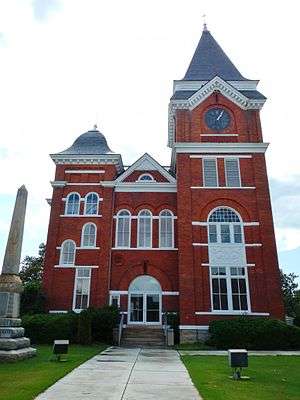 Talbot County Courthouse |
September 18, 1980 (#80001241) |
Courthouse Sq. 32°40′37″N 84°32′27″W |
Talbotton | |
| 10 | George W. B. Towns House | .JPG) George W. B. Towns House |
May 7, 1973 (#73000644) |
GA 208 32°40′43″N 84°32′45″W |
Talbotton | |
| 11 | Weeks-Kimbrough House | .JPG) Weeks-Kimbrough House |
December 27, 1979 (#79000747) |
Washington Ave. 32°40′10″N 84°32′05″W |
Talbotton | |
| 12 | Zion Episcopal Church | %3B_Talbotton%2C_GA.JPG) Zion Episcopal Church |
May 8, 1974 (#74000702) |
S of Talbotton on U.S. 80 32°40′28″N 84°32′23″W |
Talbotton |
gollark: Normally you would use something something interrupts.
gollark: I think you'd probably *not* want to do that on a Pi running Linux? That sounds very real time.
gollark: Actually, C++ compilers are sentient AI.
gollark: So you *do* do dynamic memory allocation‽!‽‽‽‽⸘
gollark: ```c#include <stdint.h>#include <stddef.h>static uintptr_t MEMPOS = 1;void* malloc(size_t size) { uintptr_t bees = MEMPOS; MEMPOS += size; return (void*)bees;}void free(void* ptr) { *(char**)ptr = "hello please do not use this address";}```
References
- "National Register of Historic Places: Weekly List Actions". National Park Service, United States Department of the Interior. Retrieved on August 14, 2020.
- Numbers represent an ordering by significant words. Various colorings, defined here, differentiate National Historic Landmarks and historic districts from other NRHP buildings, structures, sites or objects.
- The eight-digit number below each date is the number assigned to each location in the National Register Information System database, which can be viewed by clicking the number.
| Wikimedia Commons has media related to National Register of Historic Places in Talbot County, Georgia. |
| Topics | |
|---|---|
| Lists by state |
|
| Lists by insular areas | |
| Lists by associated state | |
| Other areas | |
| Related | |
| |
This article is issued from Wikipedia. The text is licensed under Creative Commons - Attribution - Sharealike. Additional terms may apply for the media files.