National Register of Historic Places listings in Forsyth County, Georgia
This is a list of properties and districts in Forsyth County, Georgia that are listed on the National Register of Historic Places (NRHP).
- This National Park Service list is complete through NPS recent listings posted August 14, 2020.[1]
Current listings
| [2] | Name on the Register | Image | Date listed[3] | Location | City or town | Description |
|---|---|---|---|---|---|---|
| 1 | Cumming Bandstand | 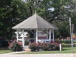 Cumming Bandstand |
June 20, 2002 (#02000658) |
Junction of Main and Dahlonega Sts. 34°12′25″N 84°08′22″W |
Cumming | |
| 2 | Cumming Cemetery | 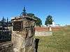 Cumming Cemetery |
May 21, 2005 (#05000428) |
Bordered by State Routes 9 and 20 and Resthaven Dr. 34°12′18″N 84°08′16″W |
Cumming | |
| 3 | Cumming Public School-Cumming High School | 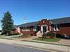 Cumming Public School-Cumming High School |
February 18, 2000 (#00000107) |
101 School St. 34°12′29″N 84°08′13″W |
Cumming | |
| 4 | Fowler Family Farm | 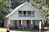 Fowler Family Farm |
April 11, 2003 (#03000200) |
3813 Atlanta Highway 34°09′18″N 84°12′36″W |
Cumming | |
| 5 | Poole's Mill Covered Bridge | 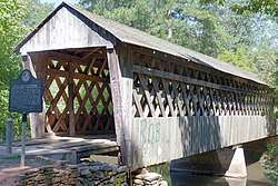 Poole's Mill Covered Bridge |
April 1, 1975 (#75000593) |
Northwest of Cumming off State Route 369 on Poole's Mill Rd. 34°17′27″N 84°14′33″W |
Cumming |
gollark: The less bad way would probably be to just install really bright lights of some sort on it, powered by fusion or something, but it wouldn't illuminate much of Mars.
gollark: Ah yes, the highly advanced space simulation engine, I should try it in that.
gollark: So you would have to reshuffle a lot of orbits and it would probably break things.
gollark: Even if we ignore the logistical difficulties, it's still going to be, well, much bigger and heavier than Phobos.
gollark: To make it a normal star.
References
- "National Register of Historic Places: Weekly List Actions". National Park Service, United States Department of the Interior. Retrieved on August 14, 2020.
- Numbers represent an ordering by significant words. Various colorings, defined here, differentiate National Historic Landmarks and historic districts from other NRHP buildings, structures, sites or objects.
- The eight-digit number below each date is the number assigned to each location in the National Register Information System database, which can be viewed by clicking the number.
| Wikimedia Commons has media related to National Register of Historic Places in Forsyth County, Georgia. |
| Topics | |
|---|---|
| Lists by state |
|
| Lists by insular areas | |
| Lists by associated state | |
| Other areas | |
| Related | |
| |
This article is issued from Wikipedia. The text is licensed under Creative Commons - Attribution - Sharealike. Additional terms may apply for the media files.