National Register of Historic Places listings in Richmond County, Georgia
This is a list of properties and districts in Richmond County, Georgia that are listed on the National Register of Historic Places (NRHP).
Augusta-Richmond was formed by merger of the independent city of Augusta, Georgia and Richmond County, Georgia.
- This National Park Service list is complete through NPS recent listings posted August 14, 2020.[1]
Current listings
| [2] | Name on the Register | Image | Date listed[3] | Location | City or town | Description |
|---|---|---|---|---|---|---|
| 1 | Academy of Richmond County | 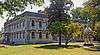 Academy of Richmond County |
April 11, 1973 (#73000639) |
540 Telfair St. 33°28′12″N 81°57′45″W |
Augusta | |
| 2 | Academy of Richmond County-1926 Campus | 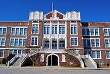 Academy of Richmond County-1926 Campus |
January 28, 2004 (#03001491) |
910 Russell St. 33°28′25″N 82°00′17″W |
Augusta | |
| 3 | Augusta Canal Industrial District | .jpg) Augusta Canal Industrial District |
May 27, 1971 (#71000285) |
Along the west bank of the Savannah River from the Richmond-Columbia county line to 10th and Fenwick Sts. 33°29′51″N 81°59′47″W |
Augusta | National Historic Landmark (canal and historic district), extends into Columbia County |
| 4 | Augusta Cotton Exchange Building | 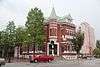 Augusta Cotton Exchange Building |
July 20, 1978 (#78001003) |
Reynolds St. 33°28′35″N 81°57′53″W |
Augusta | |
| 5 | Augusta Downtown Historic District | 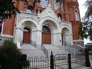 Augusta Downtown Historic District |
June 11, 2004 (#04000515) |
Roughly bounded by 13th St., Gordon Hwy., Walton Way and the Savannah R. 33°28′18″N 81°57′50″W |
Augusta | |
| 6 | Bath Presbyterian Church and Cemetery | 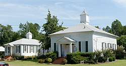 Bath Presbyterian Church and Cemetery |
October 27, 2004 (#04001179) |
Edie Bath Rd., 0.5 miles (0.80 km) west of US 1 33°20′11″N 82°10′22″W |
Blythe | |
| 7 | Stephen Vincent Benet House | .jpg) Stephen Vincent Benet House |
November 11, 1971 (#71000286) |
2500 Walton Way 33°28′33″N 82°01′27″W |
Augusta | National Historic Landmark |
| 8 | Bethlehem Historic District | Bethlehem Historic District |
December 1, 1997 (#97001470) |
Roughly bounded by Wrightsboro Rd., MLK Jr. Blvd., Railroad, Poplar, and Clay Sts. 33°27′32″N 81°59′05″W |
Augusta | |
| 9 | Brahe House | 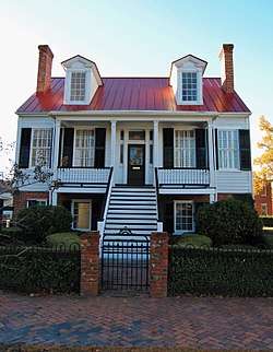 Brahe House |
April 11, 1973 (#73000640) |
456 Telfair St. 33°28′09″N 81°57′37″W |
Augusta | |
| 10 | Broad Street Historic District | 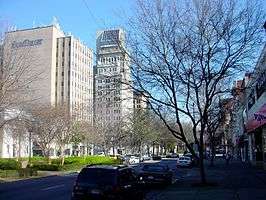 Broad Street Historic District |
April 28, 1980 (#80001226) |
Broad St. between 5th and 13th Sts. 33°28′30″N 81°58′02″W |
Augusta | |
| 11 | Cauley-Wheeler Memorial Building | June 4, 2008 (#08000493) |
1339 Laney Walker Blvd. 33°28′01″N 81°58′58″W |
Augusta | Demolished in 2011[4][5] | |
| 12 | Church of the Most Holy Trinity | 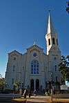 Church of the Most Holy Trinity |
March 21, 1997 (#97000250) |
720 Telfair St. 33°28′18″N 81°58′01″W |
Augusta | |
| 13 | College Hill | .jpg) College Hill |
November 11, 1971 (#71000287) |
2216 Wrightsboro Rd. 33°28′00″N 82°00′48″W |
Augusta | National Historic Landmark |
| 14 | Joseph Darling House | April 18, 1991 (#91000479) |
3066 Dennis Rd. 33°31′41″N 82°02′55″W |
Martinez | ||
| 15 | Engine Company Number One | 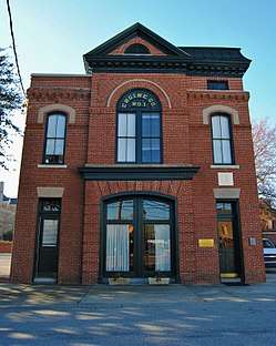 Engine Company Number One |
May 25, 1988 (#88000565) |
452 Ellis St. 33°28′17″N 81°57′34″W |
Augusta | |
| 16 | First Baptist Church of Augusta |  First Baptist Church of Augusta |
March 23, 1972 (#72000397) |
Greene and 8th Sts. 33°28′21″N 81°58′03″W |
Augusta | |
| 17 | First Presbyterian Church of Augusta | _May_2017.jpg) First Presbyterian Church of Augusta |
February 21, 1997 (#97000100) |
642 Telfair St. 33°28′13″N 81°57′54″W |
Augusta | |
| 18 | FitzSimons-Hampton House | 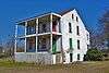 FitzSimons-Hampton House |
October 29, 1976 (#76000645) |
SR 28 33°26′59″N 81°55′17″W |
Augusta | |
| 19 | Fruitlands | Fruitlands |
May 25, 1979 (#79000742) |
2604 Washington Rd. 33°30′03″N 82°01′20″W |
Augusta | Clubhouse of the Augusta National Golf Club - admission only to members and ticket holders to tournaments[6] |
| 20 | Gertrude Herbert Art Institute | 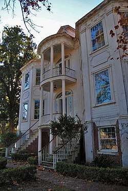 Gertrude Herbert Art Institute |
March 20, 1973 (#73000641) |
506 Telfair St. 33°28′11″N 81°57′41″W |
Augusta | |
| 21 | Gould-Weed House | 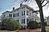 Gould-Weed House |
July 16, 1979 (#79000743) |
828 Milledge Rd. 33°28′35″N 82°00′46″W |
Augusta | |
| 22 | Greene Street Historic District |  Greene Street Historic District |
December 3, 1980 (#80001227) |
Greene St. 33°28′25″N 81°58′05″W |
Augusta | |
| 23 | Harris-Pearson-Walker House | .JPG) Harris-Pearson-Walker House |
October 28, 1969 (#69000052) |
1822 Broad St. 33°29′04″N 81°59′42″W |
Augusta | |
| 24 | Harrisburg-West End Historic District | Harrisburg-West End Historic District |
June 7, 1990 (#90000802) |
Roughly bounded by 15th St., Walton Way, Heard Ave., Milledge Rd., and the Augusta Canal 33°28′55″N 81°59′50″W |
Augusta | |
| 25 | Dr. Asbury and Martha Hull House | September 18, 2018 (#100002961) |
2749 Hillcrest Ave. 33°28′40″N 82°01′59″W |
Augusta | ||
| 26 | Lamar Building | 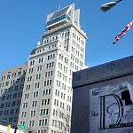 Lamar Building |
April 24, 1979 (#79000744) |
753 Broad St. 33°28′31″N 81°57′54″W |
Augusta | |
| 27 | Joseph Rucker Lamar Boyhood Home | 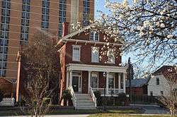 Joseph Rucker Lamar Boyhood Home |
June 13, 1996 (#96000598) |
415 7th St. 33°28′19″N 81°57′55″W |
Augusta | |
| 28 | Laney-Walker North Historic District | %2C_Augusta%2C_Richmond_County%2C_GA_HABS_GA-2370-1.tif.jpg) Laney-Walker North Historic District |
September 5, 1985 (#85001976) |
Bounded by D'Antignac, 7th, Twiggs, Phillips and Harrison Sts., Walton Way and Laney Walker Blvd. 33°28′01″N 81°58′29″W |
Augusta | |
| 29 | Liberty Methodist Church | Liberty Methodist Church |
November 7, 1997 (#97001330) |
2040 Liberty Church Rd. 33°19′12″N 82°02′17″W |
Hephzibah | |
| 30 | Meadow Garden | 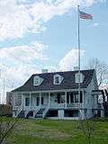 Meadow Garden |
July 19, 1976 (#76000646) |
1230 Nelson St. 33°28′26″N 81°58′47″W |
Augusta | Home of George Walton, youngest signer of the U.S. Declaration of Independence, a National Historic Landmark |
| 31 | Old Medical College Building | .jpg) Old Medical College Building |
March 16, 1972 (#72000398) |
Telfair and 6th Sts. 33°28′13″N 81°57′47″W |
Augusta | National Historic Landmark |
| 32 | Old Richmond County Courthouse |  Old Richmond County Courthouse |
December 22, 1978 (#78001004) |
432 Telfair St. 33°28′09″N 81°57′34″W |
Augusta | |
| 33 | Paine College Historic District | December 26, 2012 (#12001082) |
1235 15th St. 33°28′10″N 81°59′35″W |
Augusta | [7] | |
| 34 | Pinched Gut Historic District | 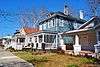 Pinched Gut Historic District |
March 6, 1980 (#80001228) |
Roughly bounded by Gordon Hwy., E. Boundary, Reynolds, and Gwinnett Sts. 33°27′47″N 81°57′22″W |
Augusta | |
| 35 | Reid-Jones-Carpenter House | .JPG) Reid-Jones-Carpenter House |
November 13, 1979 (#79000745) |
2249 Walton Way 33°28′41″N 82°00′56″W |
Augusta | |
| 36 | Sacred Heart Catholic Church | Sacred Heart Catholic Church |
March 16, 1972 (#72000399) |
Greene and 13th Sts. 33°28′38″N 81°58′37″W |
Augusta | |
| 37 | Sand Hills Historic District | 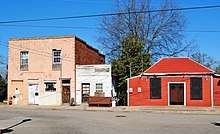 Sand Hills Historic District |
July 9, 1997 (#97000754) |
Roughly bounded by Monte Sano and North View Aves., Mount Auburn St., Johns Rd., and the Augusta Country Club. 33°29′00″N 82°01′13″W |
Augusta | Historic African-American neighborhood |
| 38 | Seclusaval and Windsor Spring | .JPG) Seclusaval and Windsor Spring |
October 11, 1988 (#87001331) |
Junction of Windsor Spring and Tobacco Rds. 33°23′05″N 82°04′21″W |
Hephzibah | |
| 39 | Shiloh Orphanage | Shiloh Orphanage |
December 30, 1996 (#96001500) |
1635 15th St. 33°27′32″N 81°59′55″W |
Augusta | |
| 40 | Springfield Baptist Church | 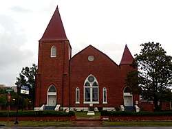 Springfield Baptist Church |
June 17, 1982 (#82002461) |
112 12th St. (original) and 114 12th St. (increase) 33°28′43″N 81°58′18″W |
Augusta | There was a boundary increase on July 5, 1990 (refnum 90000979) |
| 41 | St. Paul's Episcopal Church | %2C_605_Reynolds_Street%2C_Augusta_(Richmond_County%2C_Georgia).jpg) St. Paul's Episcopal Church |
April 11, 1973 (#73000642) |
6th and Reynolds Sts. 33°28′33″N 81°57′42″W |
Augusta | |
| 42 | Summerville Historic District |  Summerville Historic District |
May 22, 1980 (#80001229) |
Roughly bounded by Milledge Lane, Wrightsboro Rd., Highland and Heard Aves., Cumming and Henry Sts. 33°28′32″N 82°01′07″W |
Augusta | |
| 43 | Tubman High School | .jpg) Tubman High School |
March 7, 1994 (#94000154) |
1740 Walton Way 33°28′25″N 81°59′51″W |
Augusta | |
| 44 | United States Post Office and Courthouse | .jpg) United States Post Office and Courthouse |
January 21, 2000 (#99001648) |
500 E. Ford St. 33°28′20″N 81°58′03″W |
Augusta | |
| 45 | Weiss-Steinburg-Bush House | July 2, 2019 (#100004115) |
1300 Buena Vista Rd. 33°28′28″N 82°02′18″W |
Augusta | ||
| 46 | Woodrow Wilson Boyhood Home | .jpg) Woodrow Wilson Boyhood Home |
February 28, 1979 (#79000746) |
419 7th St. 33°28′18″N 81°57′54″W |
Augusta | National Historic Landmark |
| 47 | Woodlawn Historic District | July 2, 2019 (#100004122) |
Roughly bounded by Walton Way, Emmett St., Wrightsboro Rd., and Heard Ave. 33°28′12″N 82°00′18″W |
Augusta |
gollark: You can get a USB-C to Ethernet adapter.
gollark: ... wait, do you have USB or USB-C ports?
gollark: Ah. Yes. Thunderbolt. Of course.
gollark: So you could probably do it with an Ethernet cable between them, but I don't know how to configure that, look at bridging the interfaces or something.
gollark: How is your laptop connected to the interweb?
References
- "National Register of Historic Places: Weekly List Actions". National Park Service, United States Department of the Interior. Retrieved on August 14, 2020.
- Numbers represent an ordering by significant words. Various colorings, defined here, differentiate National Historic Landmarks and historic districts from other NRHP buildings, structures, sites or objects.
- The eight-digit number below each date is the number assigned to each location in the National Register Information System database, which can be viewed by clicking the number.
- MetroSpirit
- Historic Augusta - 2013 endangered property, contains photo
- Gold Club
- NPS
| Wikimedia Commons has media related to National Register of Historic Places in Richmond County, Georgia. |
| Topics | |
|---|---|
| Lists by state |
|
| Lists by insular areas | |
| Lists by associated state | |
| Other areas | |
| Related | |
| |
This article is issued from Wikipedia. The text is licensed under Creative Commons - Attribution - Sharealike. Additional terms may apply for the media files.