National Register of Historic Places listings in Whitfield County, Georgia
This is a list of properties and districts in Whitfield County, Georgia, United States, that are listed on the National Register of Historic Places (NRHP).
- This National Park Service list is complete through NPS recent listings posted August 14, 2020.[1]
Current listings
| [2] | Name on the Register | Image | Date listed[3] | Location | City or town | Description |
|---|---|---|---|---|---|---|
| 1 | Thomas A. Berry House | 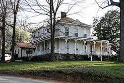 Thomas A. Berry House |
April 5, 1984 (#84001303) |
506 Hawthorne St. 34°46′33″N 84°57′47″W |
Dalton | |
| 2 | Ainsworth E. Blunt House |  Ainsworth E. Blunt House |
July 9, 1980 (#80004460) |
506 S. Thornton Ave. 34°46′00″N 84°58′19″W |
Dalton | |
| 3 | Crown Mill Historic District | 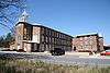 Crown Mill Historic District |
May 30, 1979 (#79000751) |
U.S. 41 34°47′03″N 84°58′22″W |
Dalton | |
| 4 | Dalton Commercial Historic District |  Dalton Commercial Historic District |
December 5, 1988 (#88001831) |
Roughly bounded by Hamilton, Pentz, Waugh and Morris Sts.; also roughly centered on Hamilton St., and bounded by S. Thornton Ave., Morris and Hawthorne Sts., and the railroad lines 34°46′16″N 84°58′05″W |
Dalton | Second set of boundaries represents a boundary increase of April 19, 2006 |
| 5 | William C. Martin House |  William C. Martin House |
July 15, 1982 (#82002497) |
101 S. Selvidge St. 34°46′16″N 84°58′15″W |
Dalton | |
| 6 | Masonic Lodge No. 238 | 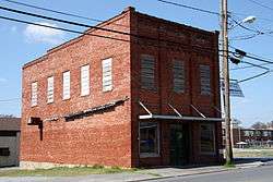 Masonic Lodge No. 238 |
February 22, 1996 (#96000127) |
600 S. Hamilton St. 34°45′57″N 84°58′05″W |
Dalton | |
| 7 | McCarty Subdivision Historic District |  McCarty Subdivision Historic District |
July 5, 2002 (#02000714) |
Thornton Place, Willow Park Dr., Sunset Cirtcle, and Walnut Ave. 34°45′35″N 84°58′20″W |
Dalton | |
| 8 | Prater's Mill | 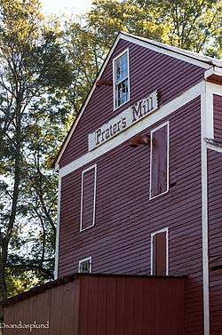 Prater's Mill |
April 25, 1978 (#78001010) |
N of Dalton on GA 2 34°53′45″N 84°55′20″W |
Dalton | |
| 9 | A. D. Strickland Store |  A. D. Strickland Store |
May 10, 2005 (#05000405) |
1385 Dawnville Rd. 34°49′17″N 84°52′45″W |
Dalton | |
| 10 | Thornton Avenue-Murray Hill Historic District |  Thornton Avenue-Murray Hill Historic District |
June 4, 1992 (#92000669) |
Roughly bounded by Crawford St., Thornton Ave., W. Franklin St., Valley Dr., Emory St. and West Hill Cemetery 34°46′04″N 84°58′28″W |
Whitfield | |
| 11 | Western and Atlantic Depot | 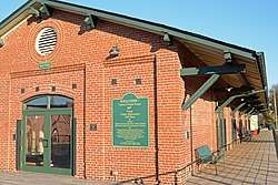 Western and Atlantic Depot |
April 6, 1978 (#78001009) |
Depot St., W end of King St. 34°46′20″N 84°58′02″W |
Dalton | Built in 1914, renovated in 2009. Also a contributing property to the Dalton Commercial Historic District and is now a visitor's center. |
| 12 | Western and Atlantic Railroad Tunnel at Tunnel Hill | 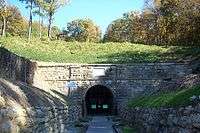 Western and Atlantic Railroad Tunnel at Tunnel Hill |
January 11, 2002 (#01001431) |
Western and Atlantic Railroad 34°50′19″N 85°01′52″W |
Tunnel Hill |
gollark: Doesn't the petrial one look identical to the nonpetrial one?
gollark: I feel like these might be hard to portray in an emoji.
gollark: <:great_stellated_dodecahedron:793814835992461343> <:small_stellated_dodecahedro:793896625856446464>
gollark: <:great_stellated_dodecahedron:793814835992461343>
gollark: <:octachoron:793811010393866240>
References
- "National Register of Historic Places: Weekly List Actions". National Park Service, United States Department of the Interior. Retrieved on August 14, 2020.
- Numbers represent an ordering by significant words. Various colorings, defined here, differentiate National Historic Landmarks and historic districts from other NRHP buildings, structures, sites or objects.
- The eight-digit number below each date is the number assigned to each location in the National Register Information System database, which can be viewed by clicking the number.
| Wikimedia Commons has media related to National Register of Historic Places in Whitfield County, Georgia. |
This article is issued from Wikipedia. The text is licensed under Creative Commons - Attribution - Sharealike. Additional terms may apply for the media files.